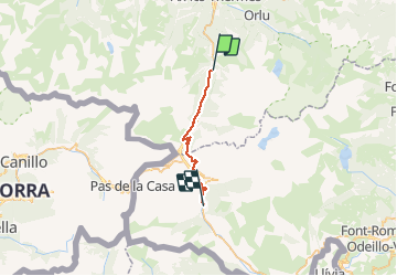
![](/images/other/stat-length.png)
![Randonnée Cheval Mérens-les-Vals - Chemin des Bonhommes - Merens Porta - Photo](https://media.geolcdn.com/t/1900/400/ext.pjpeg?maxdim=2&url=https%3A%2F%2Fservices.sitytrail.com%2FGeolivesWS%2FDownloadMedia.ashx%3FTrailID%3D108183%26Media%3D770_1.jpg)
Chemin des Bonhommes - Merens Porta
tracegps
Utilisateur
![Longueur](/images/other/stat-length.png)
Longueur
22 km
![Altitude max](https://static1.geolcdn.com/siteimages/upload/files/1508320355ic_sort_altitude_max_24dp.png)
Altitude max
2053 m
![Dénivelé positif](https://static1.geolcdn.com/siteimages/upload/files/1508320355ic_sort_den_pos_24dp.png)
Dénivelé positif
1029 m
![Km-Effort](/images/other/stat-length.png)
Km-Effort
34 km
![Altitude min](https://static1.geolcdn.com/siteimages/upload/files/1508320355ic_sort_altitude_min_24dp.png)
Altitude min
1082 m
![Dénivelé négatif](https://static1.geolcdn.com/siteimages/upload/files/1508320355ic_sort_den_neg_24dp.png)
Dénivelé négatif
595 m
![Boucle](https://static1.geolcdn.com/siteimages/upload/files/16400158638029165_repeat_loop_refresh_sync_direction_icon.png)
Boucle
Non
Date de création :
2014-12-10 00:00:00.0
Dernière modification :
2014-12-10 00:00:00.0
![Cheval](https://static1.geolcdn.com/sitytour/trail-icons/300.png)
5h30
Difficulté : Très difficile
![Scannez ce code QR pour ouvrir la randonnée dans l'application SityTrail](https://capi.geolives.com/qq0zvz2zws4bq2lad0pu/sitytour/trails/108183/qr.png?size=200)
Application GPS de randonnée GRATUITE
À propos
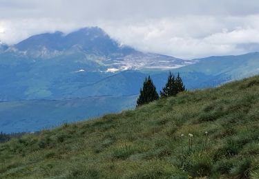
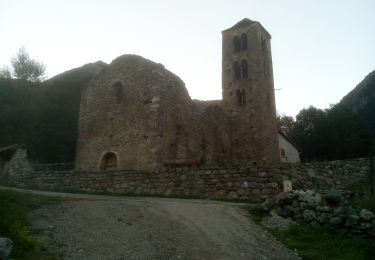
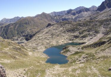
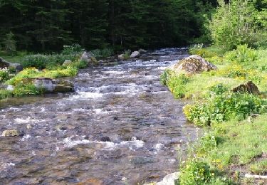
Randonnée Cheval de 22 km à découvrir à Occitanie, Ariège, Mérens-les-Vals. Cette randonnée est proposée par tracegps.
Description
Cinquième étape du Chemin des Bonhommes. Réalisée par le Bureau des Guides Équestres Transpyrénéens, cette trace fait partie des Sentiers Transfrontaliers Pyrénéens.
Localisation
Pays :
France
Région :
Occitanie
Département/Province :
Ariège
Commune :
Mérens-les-Vals
Localité :
Unknown
Départ:(Dec)
Départ:(UTM)
404440 ; 4722768 (31T) N.
Commentaires
Randonnées à proximité
![Randonnée Marche Orgeix - aiguelongue - Photo](https://media.geolcdn.com/t/375/260/ext.jpg?maxdim=2&url=https%3A%2F%2Fservices.sitytrail.com%2FGeolivesWS%2FDownloadMedia.ashx%3FTrailID%3D643989%26Media%3Dfix__20161010104856.jpg)
![Marche Marche](https://static1.geolcdn.com/sitytour/trail-icons/101.png)
![Randonnée Marche Mérens-les-Vals - Etang de Comte - Merens les Vals - Photo](https://media.geolcdn.com/t/375/260/ext.jpg?maxdim=2&url=https%3A%2F%2Fservices.sitytrail.com%2FGeolivesWS%2FDownloadMedia.ashx%3FTrailID%3D104799%26Media%3D8276_1.jpg)
![Marche Marche](https://static1.geolcdn.com/sitytour/trail-icons/101.png)
Etang de Comte - Merens les Vals
Marche
Moyen
(1)
Mérens-les-Vals,
Occitanie,
Ariège,
France
![](/images/other/stat-length.png)
6,8 km | 10,7 km-effort
2h 15min
![](https://static1.geolcdn.com/siteimages/upload/files/16400158638029165_repeat_loop_refresh_sync_direction_icon.png)
Oui
![Randonnée Marche Mérens-les-Vals - Pic de canals en boucle - Photo](https://media.geolcdn.com/t/375/260/57bc1271-5a5a-4949-81ec-e2fba4899a43.jpg&format=jpg&maxdim=2)
![Marche Marche](https://static1.geolcdn.com/sitytour/trail-icons/101.png)
Pic de canals en boucle
Marche
Moyen
Mérens-les-Vals,
Occitanie,
Ariège,
France
![](/images/other/stat-length.png)
10,7 km | 23 km-effort
6h 20min
![](https://static1.geolcdn.com/siteimages/upload/files/16400158638029165_repeat_loop_refresh_sync_direction_icon.png)
Oui
![Randonnée Marche Mérens-les-Vals - Pic de Canals - Photo](https://media.geolcdn.com/t/375/260/c8c92fc2-dcb2-4400-9d3c-800f4744a213.jpg&format=jpg&maxdim=2)
![Marche Marche](https://static1.geolcdn.com/sitytour/trail-icons/101.png)
Pic de Canals
Marche
Difficile
Mérens-les-Vals,
Occitanie,
Ariège,
France
![](/images/other/stat-length.png)
16,7 km | 31 km-effort
8h 27min
![](https://static1.geolcdn.com/siteimages/upload/files/16400158638029165_repeat_loop_refresh_sync_direction_icon.png)
Oui
![Randonnée Marche Orgeix - Pic de l'homme par les crêtes - Photo](https://media.geolcdn.com/t/375/260/ext.jpg?maxdim=2&url=https%3A%2F%2Fservices.sitytrail.com%2FGeolivesWS%2FDownloadMedia.ashx%3FTrailID%3D815731%26Media%3D50b6cd61-3adc-46d0-8ebf-fb8b362ce67b.JPG)
![Marche Marche](https://static1.geolcdn.com/sitytour/trail-icons/101.png)
Pic de l'homme par les crêtes
Marche
Difficile
Orgeix,
Occitanie,
Ariège,
France
![](/images/other/stat-length.png)
11,5 km | 27 km-effort
5h 12min
![](https://static1.geolcdn.com/siteimages/upload/files/16400158638029165_repeat_loop_refresh_sync_direction_icon.png)
Oui
![Randonnée Marche Mérens-les-Vals - le lac Couart - Photo](https://media.geolcdn.com/t/375/260/ext.jpg?maxdim=2&url=https%3A%2F%2Fservices.sitytrail.com%2FGeolivesWS%2FDownloadMedia.ashx%3FTrailID%3D315324%26Media%3Dfix__20140622084804.jpg)
![Marche Marche](https://static1.geolcdn.com/sitytour/trail-icons/101.png)
le lac Couart
Marche
Difficile
Mérens-les-Vals,
Occitanie,
Ariège,
France
![](/images/other/stat-length.png)
15 km | 26 km-effort
7h 33min
![](https://static1.geolcdn.com/siteimages/upload/files/16400158638029165_repeat_loop_refresh_sync_direction_icon.png)
Oui
![Randonnée Marche Orgeix - Lac d ' Aiguelongue - Photo](https://media.geolcdn.com/t/375/260/ext.jpg?maxdim=2&url=https%3A%2F%2Fservices.sitytrail.com%2FGeolivesWS%2FDownloadMedia.ashx%3FTrailID%3D314853%26Media%3Dfix__20140621082519.jpg)
![Marche Marche](https://static1.geolcdn.com/sitytour/trail-icons/101.png)
Lac d ' Aiguelongue
Marche
Moyen
Orgeix,
Occitanie,
Ariège,
France
![](/images/other/stat-length.png)
9,2 km | 18,1 km-effort
4h 10min
![](https://static1.geolcdn.com/siteimages/upload/files/16400158638029165_repeat_loop_refresh_sync_direction_icon.png)
Oui
![Randonnée Marche Mérens-les-Vals - Col de Joux depuis Merens les Vals - Variante retour route forestiere - Photo](https://media.geolcdn.com/t/375/260/9b2dcdb9-e06a-4bf5-bac1-56efbf13e437.jpg&format=jpg&maxdim=2)
![Marche Marche](https://static1.geolcdn.com/sitytour/trail-icons/101.png)
Col de Joux depuis Merens les Vals - Variante retour route forestiere
Marche
Moyen
Mérens-les-Vals,
Occitanie,
Ariège,
France
![](/images/other/stat-length.png)
12,3 km | 22 km-effort
5h 2min
![](https://static1.geolcdn.com/siteimages/upload/files/16400158638029165_repeat_loop_refresh_sync_direction_icon.png)
Oui
![Randonnée Marche Mérens-les-Vals - cécé Gégé lac de comte - Photo](https://media.geolcdn.com/t/375/260/8e57eb6c-eeb0-4ed3-9d16-21fcfeb537b4.jpg&format=jpg&maxdim=2)
![Marche Marche](https://static1.geolcdn.com/sitytour/trail-icons/101.png)
cécé Gégé lac de comte
Marche
Très difficile
Mérens-les-Vals,
Occitanie,
Ariège,
France
![](/images/other/stat-length.png)
13,3 km | 23 km-effort
6h 24min
![](https://static1.geolcdn.com/siteimages/upload/files/16400158638029165_repeat_loop_refresh_sync_direction_icon.png)
Oui