![](/images/other/stat-length.png)
![Randonnée Marche Champrond-en-Perchet - Champrond en Perchet - Photo](https://media.geolcdn.com/t/1900/400/ext.pjpeg?maxdim=2&url=https%3A%2F%2Fservices.sitytrail.com%2FGeolivesWS%2FDownloadMedia.ashx%3FTrailID%3D107728%26Media%3D12781_1.jpg)
Champrond en Perchet
tracegps
Utilisateur
![Longueur](/images/other/stat-length.png)
Longueur
8,1 km
![Altitude max](https://static1.geolcdn.com/siteimages/upload/files/1508320355ic_sort_altitude_max_24dp.png)
Altitude max
220 m
![Dénivelé positif](https://static1.geolcdn.com/siteimages/upload/files/1508320355ic_sort_den_pos_24dp.png)
Dénivelé positif
109 m
![Km-Effort](/images/other/stat-length.png)
Km-Effort
9,6 km
![Altitude min](https://static1.geolcdn.com/siteimages/upload/files/1508320355ic_sort_altitude_min_24dp.png)
Altitude min
160 m
![Dénivelé négatif](https://static1.geolcdn.com/siteimages/upload/files/1508320355ic_sort_den_neg_24dp.png)
Dénivelé négatif
116 m
![Boucle](https://static1.geolcdn.com/siteimages/upload/files/16400158638029165_repeat_loop_refresh_sync_direction_icon.png)
Boucle
Oui
Date de création :
2014-12-10 00:00:00.0
Dernière modification :
2014-12-10 00:00:00.0
![Marche](https://static1.geolcdn.com/sitytour/trail-icons/101.png)
1h30
Difficulté : Facile
![Scannez ce code QR pour ouvrir la randonnée dans l'application SityTrail](https://capi.geolives.com/qq0zvz2zws4bq2lad0pu/sitytour/trails/107728/qr.png?size=200)
Application GPS de randonnée GRATUITE
À propos
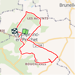
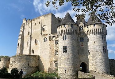
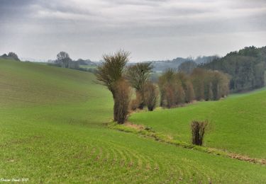
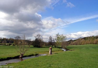
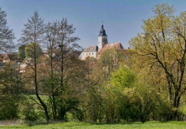
Randonnée Marche de 8,1 km à découvrir à Centre-Val de Loire, Eure-et-Loir, Champrond-en-Perchet. Cette randonnée est proposée par tracegps.
Description
Aucunes difficultés particulières. Peu de chemins de terre boueux en cas de pluie. La tranquillité, le calme...
Localisation
Pays :
France
Région :
Centre-Val de Loire
Département/Province :
Eure-et-Loir
Commune :
Champrond-en-Perchet
Localité :
Unknown
Départ:(Dec)
Départ:(UTM)
341730 ; 5353082 (31U) N.
Commentaires
Randonnées à proximité
![Randonnée Marche Trizay-Coutretot-Saint-Serge - 100 Kms Perche Boucle B - Photo](https://media.geolcdn.com/t/375/260/ext.jpg?maxdim=2&url=https%3A%2F%2Fstatic1.geolcdn.com%2Fsiteimages%2Fupload%2Ffiles%2F1553511878bg_sport_marche.png)
![Marche Marche](https://static1.geolcdn.com/sitytour/trail-icons/101.png)
100 Kms Perche Boucle B
Marche
Difficile
(2)
Trizay-Coutretot-Saint-Serge,
Centre-Val de Loire,
Eure-et-Loir,
France
![](/images/other/stat-length.png)
48 km | 56 km-effort
12h 1min
![](https://static1.geolcdn.com/siteimages/upload/files/16400158638029165_repeat_loop_refresh_sync_direction_icon.png)
Oui
![Randonnée Marche Arcisses - Coudreceau, les panoramas du Perche Eurélien 9,4 km - Photo](https://media.geolcdn.com/t/375/260/93185f9c-ce34-4e92-883e-ab49829b2889.jpeg&format=jpg&maxdim=2)
![Marche Marche](https://static1.geolcdn.com/sitytour/trail-icons/101.png)
Coudreceau, les panoramas du Perche Eurélien 9,4 km
Marche
Moyen
Arcisses,
Centre-Val de Loire,
Eure-et-Loir,
France
![](/images/other/stat-length.png)
9,4 km | 11,4 km-effort
2h 35min
![](https://static1.geolcdn.com/siteimages/upload/files/16400158638029165_repeat_loop_refresh_sync_direction_icon.png)
Oui
![Randonnée Marche Vichères - Vichères - la colline de Rougemont 8 km - Photo](https://media.geolcdn.com/t/375/260/fab65f98-ee3c-448f-86cc-f0faa2c1c5aa.jpeg&format=jpg&maxdim=2)
![Marche Marche](https://static1.geolcdn.com/sitytour/trail-icons/101.png)
Vichères - la colline de Rougemont 8 km
Marche
Moyen
Vichères,
Centre-Val de Loire,
Eure-et-Loir,
France
![](/images/other/stat-length.png)
8 km | 10,3 km-effort
2h 20min
![](https://static1.geolcdn.com/siteimages/upload/files/16400158638029165_repeat_loop_refresh_sync_direction_icon.png)
Oui
![Randonnée Marche Arcisses - Brunelles - Autour du Promontoire 10 km - Photo](https://media.geolcdn.com/t/375/260/d22874c5-839f-4011-a0f9-00e8c44e1208.jpeg&format=jpg&maxdim=2)
![Marche Marche](https://static1.geolcdn.com/sitytour/trail-icons/101.png)
Brunelles - Autour du Promontoire 10 km
Marche
Moyen
Arcisses,
Centre-Val de Loire,
Eure-et-Loir,
France
![](/images/other/stat-length.png)
10,1 km | 11,6 km-effort
2h 37min
![](https://static1.geolcdn.com/siteimages/upload/files/16400158638029165_repeat_loop_refresh_sync_direction_icon.png)
Oui
![Randonnée Marche Nogent-le-Rotrou - NOGENT LE ROTROU - Photo](https://media.geolcdn.com/t/375/260/c00ba3d7-9b96-49a3-b019-bc489240b465.jpg&format=jpg&maxdim=2)
![Marche Marche](https://static1.geolcdn.com/sitytour/trail-icons/101.png)
NOGENT LE ROTROU
Marche
Moyen
Nogent-le-Rotrou,
Centre-Val de Loire,
Eure-et-Loir,
France
![](/images/other/stat-length.png)
5,8 km | 6,9 km-effort
1h 33min
![](https://static1.geolcdn.com/siteimages/upload/files/16400158638029165_repeat_loop_refresh_sync_direction_icon.png)
Oui
![Randonnée Marche Arcisses - Ozée 9,1 km - Photo](https://media.geolcdn.com/t/375/260/ext.jpg?maxdim=2&url=https%3A%2F%2Fstatic1.geolcdn.com%2Fsiteimages%2Fupload%2Ffiles%2F1553511878bg_sport_marche.png)
![Marche Marche](https://static1.geolcdn.com/sitytour/trail-icons/101.png)
Ozée 9,1 km
Marche
Moyen
(1)
Arcisses,
Centre-Val de Loire,
Eure-et-Loir,
France
![](/images/other/stat-length.png)
9,1 km | 11,2 km-effort
2h 32min
![](https://static1.geolcdn.com/siteimages/upload/files/16400158638029165_repeat_loop_refresh_sync_direction_icon.png)
Oui
![Randonnée Marche La Gaudaine - La Gaudaine - les panoramas 12 km - Photo](https://media.geolcdn.com/t/375/260/7d44d83e-0c4d-469b-b2b8-1846d9ca6509.jpeg&format=jpg&maxdim=2)
![Marche Marche](https://static1.geolcdn.com/sitytour/trail-icons/101.png)
La Gaudaine - les panoramas 12 km
Marche
Facile
La Gaudaine,
Centre-Val de Loire,
Eure-et-Loir,
France
![](/images/other/stat-length.png)
11,9 km | 14,9 km-effort
5min
![](https://static1.geolcdn.com/siteimages/upload/files/16400158638029165_repeat_loop_refresh_sync_direction_icon.png)
Oui
![Randonnée Marche Nogent-le-Rotrou - Nogent-le-Rotrou - Saint-Victor-de-Buthon 19 km - Photo](https://media.geolcdn.com/t/375/260/c6e34c0a-1640-462d-a835-4ae8958f9be6.jpg&format=jpg&maxdim=2)
![Marche Marche](https://static1.geolcdn.com/sitytour/trail-icons/101.png)
Nogent-le-Rotrou - Saint-Victor-de-Buthon 19 km
Marche
Très difficile
Nogent-le-Rotrou,
Centre-Val de Loire,
Eure-et-Loir,
France
![](/images/other/stat-length.png)
19 km | 23 km-effort
5h 5min
![](https://static1.geolcdn.com/siteimages/upload/files/16400158638029165_repeat_loop_refresh_sync_direction_icon.png)
Non
![Randonnée Marche Nogent-le-Rotrou - Nogent-le-Rotrou - Thiron-Gardais via La Gaudaine 22 km - Photo](https://media.geolcdn.com/t/375/260/8889b3ec-9799-4b99-8939-6db73505b4bd.jpg&format=jpg&maxdim=2)
![Marche Marche](https://static1.geolcdn.com/sitytour/trail-icons/101.png)
Nogent-le-Rotrou - Thiron-Gardais via La Gaudaine 22 km
Marche
Très difficile
Nogent-le-Rotrou,
Centre-Val de Loire,
Eure-et-Loir,
France
![](/images/other/stat-length.png)
22 km | 26 km-effort
6h 0min
![](https://static1.geolcdn.com/siteimages/upload/files/16400158638029165_repeat_loop_refresh_sync_direction_icon.png)
Non