![](/images/other/stat-length.png)
![Randonnée Marche Puéchabon - Puechabon Pont du Diable - Photo](https://media.geolcdn.com/t/1900/400/ext.pjpeg?maxdim=2&url=https%3A%2F%2Fstatic1.geolcdn.com%2Fsiteimages%2Fupload%2Ffiles%2F1553511878bg_sport_marche.png)
Puechabon Pont du Diable
Manontom
Utilisateur
![Longueur](/images/other/stat-length.png)
Longueur
15,3 km
![Altitude max](https://static1.geolcdn.com/siteimages/upload/files/1508320355ic_sort_altitude_max_24dp.png)
Altitude max
298 m
![Dénivelé positif](https://static1.geolcdn.com/siteimages/upload/files/1508320355ic_sort_den_pos_24dp.png)
Dénivelé positif
365 m
![Km-Effort](/images/other/stat-length.png)
Km-Effort
20 km
![Altitude min](https://static1.geolcdn.com/siteimages/upload/files/1508320355ic_sort_altitude_min_24dp.png)
Altitude min
53 m
![Dénivelé négatif](https://static1.geolcdn.com/siteimages/upload/files/1508320355ic_sort_den_neg_24dp.png)
Dénivelé négatif
363 m
![Boucle](https://static1.geolcdn.com/siteimages/upload/files/16400158638029165_repeat_loop_refresh_sync_direction_icon.png)
Boucle
Oui
Date de création :
2019-01-15 19:08:56.791
Dernière modification :
2019-01-15 19:08:56.791
![Marche](https://static1.geolcdn.com/sitytour/trail-icons/101.png)
4h30
Difficulté : Moyen
![Scannez ce code QR pour ouvrir la randonnée dans l'application SityTrail](https://capi.geolives.com/qq0zvz2zws4bq2lad0pu/sitytour/trails/1075580/qr.png?size=200)
Application GPS de randonnée GRATUITE
À propos
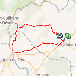
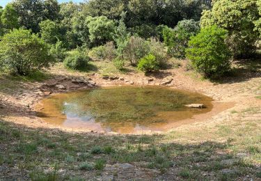
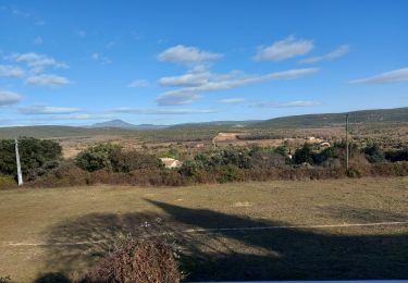
Randonnée Marche de 15,3 km à découvrir à Occitanie, Hérault, Puéchabon. Cette randonnée est proposée par Manontom.
Description
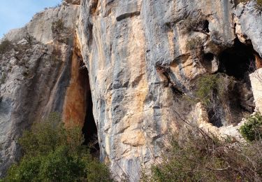
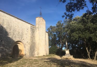
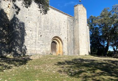
Bergerie Neuve ,hameau de Lavène ,ruines de Montcalmes ,vue sur St. Guilhem ,Balcon de l'Hérault ,pont du Diable ,église de St. Sylvestre des Brousses.
Localisation
Pays :
France
Région :
Occitanie
Département/Province :
Hérault
Commune :
Puéchabon
Localité :
Unknown
Départ:(Dec)
Départ:(UTM)
549619 ; 4840457 (31T) N.
Commentaires
Randonnées à proximité
![Randonnée Marche Aniane - Aniane ruisseau des Corbières - Photo](https://media.geolcdn.com/t/375/260/ext.jpg?maxdim=2&url=https%3A%2F%2Fservices.sitytrail.com%2FGeolivesWS%2FDownloadMedia.ashx%3FTrailID%3D371677%26Media%3D20141221154017.jpg)
![Marche Marche](https://static1.geolcdn.com/sitytour/trail-icons/101.png)
Aniane ruisseau des Corbières
Marche
Facile
(3)
Aniane,
Occitanie,
Hérault,
France
![](/images/other/stat-length.png)
9,5 km | 12 km-effort
2h 34min
![](https://static1.geolcdn.com/siteimages/upload/files/16400158638029165_repeat_loop_refresh_sync_direction_icon.png)
Oui
![Randonnée Marche Saint-Guilhem-le-Désert - Herault - St-Guilhem-le-Desert le Roc de la Vigne depuis le barrage 12km 609m - Photo](https://media.geolcdn.com/t/375/260/ext.jpg?maxdim=2&url=https%3A%2F%2Fstatic1.geolcdn.com%2Fsiteimages%2Fupload%2Ffiles%2F1553511878bg_sport_marche.png)
![Marche Marche](https://static1.geolcdn.com/sitytour/trail-icons/101.png)
Herault - St-Guilhem-le-Desert le Roc de la Vigne depuis le barrage 12km 609m
Marche
Moyen
(1)
Saint-Guilhem-le-Désert,
Occitanie,
Hérault,
France
![](/images/other/stat-length.png)
12,1 km | 21 km-effort
4h 17min
![](https://static1.geolcdn.com/siteimages/upload/files/16400158638029165_repeat_loop_refresh_sync_direction_icon.png)
Oui
![Randonnée Marche Puéchabon - Causse Puechabon - Photo](https://media.geolcdn.com/t/375/260/ext.jpg?maxdim=2&url=https%3A%2F%2Fstatic1.geolcdn.com%2Fsiteimages%2Fupload%2Ffiles%2F1553511878bg_sport_marche.png)
![Marche Marche](https://static1.geolcdn.com/sitytour/trail-icons/101.png)
Causse Puechabon
Marche
Très facile
(1)
Puéchabon,
Occitanie,
Hérault,
France
![](/images/other/stat-length.png)
12,8 km | 15,9 km-effort
Inconnu
![](https://static1.geolcdn.com/siteimages/upload/files/16400158638029165_repeat_loop_refresh_sync_direction_icon.png)
Oui
![Randonnée Marche Aniane - Plateau Montcamès - Photo](https://media.geolcdn.com/t/375/260/b02f8392-ab26-453d-ab12-fab47a60d22f.jpg&format=jpg&maxdim=2)
![Marche Marche](https://static1.geolcdn.com/sitytour/trail-icons/101.png)
Plateau Montcamès
Marche
Très difficile
Aniane,
Occitanie,
Hérault,
France
![](/images/other/stat-length.png)
17,7 km | 23 km-effort
6h 21min
![](https://static1.geolcdn.com/siteimages/upload/files/16400158638029165_repeat_loop_refresh_sync_direction_icon.png)
Oui
![Randonnée Marche Saint-Guilhem-le-Désert - De baume en baumes à St Guilhem - Photo](https://media.geolcdn.com/t/375/260/050c206e-bec0-425f-8b81-0f24a249a5b8.jpg&format=jpg&maxdim=2)
![Marche Marche](https://static1.geolcdn.com/sitytour/trail-icons/101.png)
De baume en baumes à St Guilhem
Marche
Moyen
Saint-Guilhem-le-Désert,
Occitanie,
Hérault,
France
![](/images/other/stat-length.png)
10 km | 15,8 km-effort
3h 28min
![](https://static1.geolcdn.com/siteimages/upload/files/16400158638029165_repeat_loop_refresh_sync_direction_icon.png)
Non
![Randonnée Marche Puéchabon - Chapelle Saint-Sylvestre - Pioch de Ła Bastide - Photo](https://media.geolcdn.com/t/375/260/4441e2d5-932c-421a-a6dd-deaeea6979dd.jpg&format=jpg&maxdim=2)
![Marche Marche](https://static1.geolcdn.com/sitytour/trail-icons/101.png)
Chapelle Saint-Sylvestre - Pioch de Ła Bastide
Marche
Difficile
Puéchabon,
Occitanie,
Hérault,
France
![](/images/other/stat-length.png)
15,2 km | 19,3 km-effort
5h 27min
![](https://static1.geolcdn.com/siteimages/upload/files/16400158638029165_repeat_loop_refresh_sync_direction_icon.png)
Oui
![Randonnée Marche Puéchabon - Puechabon les crêtes de l’Herault - Photo](https://media.geolcdn.com/t/375/260/c7bd78fa-f414-42bd-9938-fea417bb3fa7.jpg&format=jpg&maxdim=2)
![Marche Marche](https://static1.geolcdn.com/sitytour/trail-icons/101.png)
Puechabon les crêtes de l’Herault
Marche
Très difficile
Puéchabon,
Occitanie,
Hérault,
France
![](/images/other/stat-length.png)
19 km | 25 km-effort
6h 9min
![](https://static1.geolcdn.com/siteimages/upload/files/16400158638029165_repeat_loop_refresh_sync_direction_icon.png)
Oui
![Randonnée Marche Puéchabon - Le Plateau de Montcalmes par Puechabon - Photo](https://media.geolcdn.com/t/375/260/84ea9223-3f2e-4af8-9c1e-d39ae19bc16b.jpg&format=jpg&maxdim=2)
![Marche Marche](https://static1.geolcdn.com/sitytour/trail-icons/101.png)
Le Plateau de Montcalmes par Puechabon
Marche
Difficile
Puéchabon,
Occitanie,
Hérault,
France
![](/images/other/stat-length.png)
14,7 km | 18,3 km-effort
5h 41min
![](https://static1.geolcdn.com/siteimages/upload/files/16400158638029165_repeat_loop_refresh_sync_direction_icon.png)
Oui
![Randonnée Marche Argelliers - Arsel Argelliers Montarnaud - Photo](https://media.geolcdn.com/t/375/260/f29931cb-207b-4689-a4f5-5240bd009557.jpg&format=jpg&maxdim=2)
![Marche Marche](https://static1.geolcdn.com/sitytour/trail-icons/101.png)
Arsel Argelliers Montarnaud
Marche
Très facile
Argelliers,
Occitanie,
Hérault,
France
![](/images/other/stat-length.png)
19,7 km | 24 km-effort
4h 20min
![](https://static1.geolcdn.com/siteimages/upload/files/16400158638029165_repeat_loop_refresh_sync_direction_icon.png)
Oui