![](/images/other/stat-length.png)
![Randonnée V.T.T. Montoir-de-Bretagne - Tour de Briere - Montoir de Bretagne - Photo](https://media.geolcdn.com/t/1900/400/ext.pjpeg?maxdim=2&url=https%3A%2F%2Fstatic1.geolcdn.com%2Fsiteimages%2Fupload%2Ffiles%2F1524743154velo.jpg)
Tour de Briere - Montoir de Bretagne
tracegps
Utilisateur
![Longueur](/images/other/stat-length.png)
Longueur
68 km
![Altitude max](https://static1.geolcdn.com/siteimages/upload/files/1508320355ic_sort_altitude_max_24dp.png)
Altitude max
16 m
![Dénivelé positif](https://static1.geolcdn.com/siteimages/upload/files/1508320355ic_sort_den_pos_24dp.png)
Dénivelé positif
276 m
![Km-Effort](/images/other/stat-length.png)
Km-Effort
72 km
![Altitude min](https://static1.geolcdn.com/siteimages/upload/files/1508320355ic_sort_altitude_min_24dp.png)
Altitude min
-5 m
![Dénivelé négatif](https://static1.geolcdn.com/siteimages/upload/files/1508320355ic_sort_den_neg_24dp.png)
Dénivelé négatif
276 m
![Boucle](https://static1.geolcdn.com/siteimages/upload/files/16400158638029165_repeat_loop_refresh_sync_direction_icon.png)
Boucle
Oui
Date de création :
2014-12-10 00:00:00.0
Dernière modification :
2014-12-10 00:00:00.0
![V.T.T.](https://static1.geolcdn.com/sitytour/trail-icons/202.png)
6h00
Difficulté : Moyen
![Scannez ce code QR pour ouvrir la randonnée dans l'application SityTrail](https://capi.geolives.com/qq0zvz2zws4bq2lad0pu/sitytour/trails/107511/qr.png?size=200)
Application GPS de randonnée GRATUITE
À propos
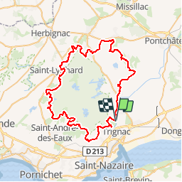
Randonnée V.T.T. de 68 km à découvrir à Pays de la Loire, Loire-Atlantique, Montoir-de-Bretagne. Cette randonnée est proposée par tracegps.
Description
Parcours de 70 km de découverte autour du marais, inondable en Hiver. Chemins plats mais marqués par les trous des sabots.
Localisation
Pays :
France
Région :
Pays de la Loire
Département/Province :
Loire-Atlantique
Commune :
Montoir-de-Bretagne
Localité :
Unknown
Départ:(Dec)
Départ:(UTM)
561209 ; 5242246 (30T) N.
Commentaires
Randonnées à proximité
![Randonnée A pied Saint-Malo-de-Guersac - Les Chaussées - Photo](https://media.geolcdn.com/t/375/260/ext.jpg?maxdim=2&url=https%3A%2F%2Fmedia.geolcdn.com%2Ff%2Fed9f4f37-5424-4cdf-97c9-60da3a524041.jpeg)
![A pied A pied](https://static1.geolcdn.com/sitytour/trail-icons/100.png)
Les Chaussées
A pied
Facile
Saint-Malo-de-Guersac,
Pays de la Loire,
Loire-Atlantique,
France
![](/images/other/stat-length.png)
8,9 km | 9,3 km-effort
2h 6min
![](https://static1.geolcdn.com/siteimages/upload/files/16400158638029165_repeat_loop_refresh_sync_direction_icon.png)
Oui
![Randonnée A pied Saint-Malo-de-Guersac - Les Gagneries - Photo](https://media.geolcdn.com/t/375/260/ext.jpg?maxdim=2&url=https%3A%2F%2Fmedia.geolcdn.com%2Ff%2Fed9f4f37-5424-4cdf-97c9-60da3a524041.jpeg)
![A pied A pied](https://static1.geolcdn.com/sitytour/trail-icons/100.png)
Les Gagneries
A pied
Facile
Saint-Malo-de-Guersac,
Pays de la Loire,
Loire-Atlantique,
France
![](/images/other/stat-length.png)
5,5 km | 5,7 km-effort
1h 18min
![](https://static1.geolcdn.com/siteimages/upload/files/16400158638029165_repeat_loop_refresh_sync_direction_icon.png)
Oui
![Randonnée Marche Saint-Nazaire - SAINT NAZAIRE - Photo](https://media.geolcdn.com/t/375/260/ext.jpg?maxdim=2&url=https%3A%2F%2Fmedia.geolcdn.com%2Ff%2F37163d3e-ced5-435f-810d-ef2d61812b64.jpg)
![Marche Marche](https://static1.geolcdn.com/sitytour/trail-icons/101.png)
SAINT NAZAIRE
Marche
Facile
Saint-Nazaire,
Pays de la Loire,
Loire-Atlantique,
France
![](/images/other/stat-length.png)
9,7 km | 10,7 km-effort
2h 20min
![](https://static1.geolcdn.com/siteimages/upload/files/16400158638029165_repeat_loop_refresh_sync_direction_icon.png)
Oui
![Randonnée Randonnée équestre Saint-Malo-de-Guersac - TRAIL TOUR DE BRIERE - Photo](https://media.geolcdn.com/t/375/260/ext.jpg?maxdim=2&url=https%3A%2F%2Fstatic1.geolcdn.com%2Fsiteimages%2Fupload%2Ffiles%2F1524743154cheval.jpg)
![Randonnée équestre Randonnée équestre](https://static1.geolcdn.com/sitytour/trail-icons/301.png)
TRAIL TOUR DE BRIERE
Randonnée équestre
Très difficile
Saint-Malo-de-Guersac,
Pays de la Loire,
Loire-Atlantique,
France
![](/images/other/stat-length.png)
67 km | 71 km-effort
9h 16min
![](https://static1.geolcdn.com/siteimages/upload/files/16400158638029165_repeat_loop_refresh_sync_direction_icon.png)
Oui
![Randonnée V.T.T. Trignac - vtt Jacques st Nazaire - Photo](https://media.geolcdn.com/t/375/260/ext.jpg?maxdim=2&url=https%3A%2F%2Fstatic1.geolcdn.com%2Fsiteimages%2Fupload%2Ffiles%2F1524743154velo.jpg)
![V.T.T. V.T.T.](https://static1.geolcdn.com/sitytour/trail-icons/202.png)
vtt Jacques st Nazaire
V.T.T.
Difficile
Trignac,
Pays de la Loire,
Loire-Atlantique,
France
![](/images/other/stat-length.png)
29 km | 32 km-effort
2h 9min
![](https://static1.geolcdn.com/siteimages/upload/files/16400158638029165_repeat_loop_refresh_sync_direction_icon.png)
Oui
![Randonnée Marche Montoir-de-Bretagne - Briere - Photo](https://media.geolcdn.com/t/375/260/ext.jpg?maxdim=2&url=https%3A%2F%2Fstatic1.geolcdn.com%2Fsiteimages%2Fupload%2Ffiles%2F1553511878bg_sport_marche.png)
![Marche Marche](https://static1.geolcdn.com/sitytour/trail-icons/101.png)
Briere
Marche
Montoir-de-Bretagne,
Pays de la Loire,
Loire-Atlantique,
France
![](/images/other/stat-length.png)
5,9 km | 6,2 km-effort
1h 23min
![](https://static1.geolcdn.com/siteimages/upload/files/16400158638029165_repeat_loop_refresh_sync_direction_icon.png)
Non
![Randonnée Marche Saint-Malo-de-Guersac - Rando des Hérons 2019 - Photo](https://media.geolcdn.com/t/375/260/ext.jpg?maxdim=2&url=https%3A%2F%2Fstatic1.geolcdn.com%2Fsiteimages%2Fupload%2Ffiles%2F1553511878bg_sport_marche.png)
![Marche Marche](https://static1.geolcdn.com/sitytour/trail-icons/101.png)
Rando des Hérons 2019
Marche
Facile
Saint-Malo-de-Guersac,
Pays de la Loire,
Loire-Atlantique,
France
![](/images/other/stat-length.png)
15,4 km | 16,1 km-effort
3h 35min
![](https://static1.geolcdn.com/siteimages/upload/files/16400158638029165_repeat_loop_refresh_sync_direction_icon.png)
Oui
![Randonnée Marche Donges - Donges_Chemin des villages - Photo](https://media.geolcdn.com/t/375/260/ext.jpg?maxdim=2&url=https%3A%2F%2Fstatic1.geolcdn.com%2Fsiteimages%2Fupload%2Ffiles%2F1553511878bg_sport_marche.png)
![Marche Marche](https://static1.geolcdn.com/sitytour/trail-icons/101.png)
Donges_Chemin des villages
Marche
Facile
Donges,
Pays de la Loire,
Loire-Atlantique,
France
![](/images/other/stat-length.png)
9,7 km | 10,5 km-effort
2h 20min
![](https://static1.geolcdn.com/siteimages/upload/files/16400158638029165_repeat_loop_refresh_sync_direction_icon.png)
Oui
![Randonnée V.T.T. Montoir-de-Bretagne - Tour de la Grande Brière - Photo](https://media.geolcdn.com/t/375/260/ext.jpg?maxdim=2&url=https%3A%2F%2Fstatic1.geolcdn.com%2Fsiteimages%2Fupload%2Ffiles%2F1524743154velo.jpg)
![V.T.T. V.T.T.](https://static1.geolcdn.com/sitytour/trail-icons/202.png)
Tour de la Grande Brière
V.T.T.
Moyen
Montoir-de-Bretagne,
Pays de la Loire,
Loire-Atlantique,
France
![](/images/other/stat-length.png)
66 km | 70 km-effort
6h 0min
![](https://static1.geolcdn.com/siteimages/upload/files/16400158638029165_repeat_loop_refresh_sync_direction_icon.png)
Oui