![](/images/other/stat-length.png)
![Randonnée V.T.T. Malemort-du-Comtat - Rando découverte Malemort du Comtat - Blauvac - Photo](https://media.geolcdn.com/t/1900/400/ext.pjpeg?maxdim=2&url=https%3A%2F%2Fservices.sitytrail.com%2FGeolivesWS%2FDownloadMedia.ashx%3FTrailID%3D107478%26Media%3D12423_5.jpg)
Rando découverte Malemort du Comtat - Blauvac
tracegps
Utilisateur
![Longueur](/images/other/stat-length.png)
![Altitude max](https://static1.geolcdn.com/siteimages/upload/files/1508320355ic_sort_altitude_max_24dp.png)
![Dénivelé positif](https://static1.geolcdn.com/siteimages/upload/files/1508320355ic_sort_den_pos_24dp.png)
![Km-Effort](/images/other/stat-length.png)
![Altitude min](https://static1.geolcdn.com/siteimages/upload/files/1508320355ic_sort_altitude_min_24dp.png)
![Dénivelé négatif](https://static1.geolcdn.com/siteimages/upload/files/1508320355ic_sort_den_neg_24dp.png)
![Boucle](https://static1.geolcdn.com/siteimages/upload/files/16400158638029165_repeat_loop_refresh_sync_direction_icon.png)
![V.T.T.](https://static1.geolcdn.com/sitytour/trail-icons/202.png)
3h30
Difficulté : Difficile
![Scannez ce code QR pour ouvrir la randonnée dans l'application SityTrail](https://capi.geolives.com/qq0zvz2zws4bq2lad0pu/sitytour/trails/107478/qr.png?size=200)
Application GPS de randonnée GRATUITE
À propos
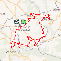
Randonnée V.T.T. de 28 km à découvrir à Provence-Alpes-Côte d'Azur, Vaucluse, Malemort-du-Comtat. Cette randonnée est proposée par tracegps.
Description
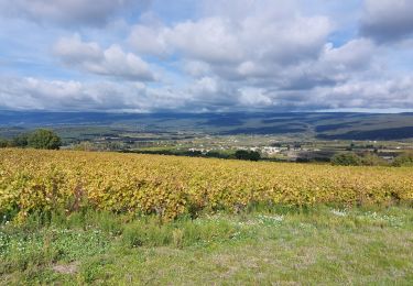
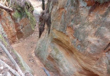
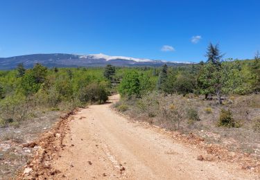
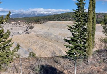
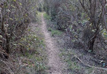
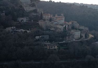
Départ de Malemort du Comtat où vous emprunterez une petite route, vue sur le village de Venasque à droite perché sur la montagne, puis un sentier balisé (trait jaune) pendant 3km puis 600m de route obligatoire pour éviter un secteur privé. Passage à Notre-Dame de Vie où vous pouvez faire le plein d'eau bénite pas de ravitaillement possible par la suite, soyez prévoyant. Au km5 vous passerez à proximité de la ferme pédagogique sur le parc, vous aurez la possibilité de faire une boucle balisée par la ferme du n°1 à 27 à travers les vignes et les cerisiers où vous trouverez des pupitres en bois qui vous informeront sur la façon de ramasser les olives, de vendanger le raisin etc... (en saison de Avril à Octobre). 1,5km plus loin vous apercevrez sur votre droite une borie, cabane en pierre sèche typique de la région. Deux ou 3 autres un peu plus loin, passage à la croix de la Gardy pour redescendre sur Malemort puis direction Blauvac et retour sur Malemort par des chemins forestiers ou agricoles et des singles en sous bois très sympas. De nombreux panoramas tout au long du parcours. Bonne rando.
Localisation
Commentaires
Randonnées à proximité
![Randonnée Marche Malemort-du-Comtat - malemort de Comtat PR19 - Photo](https://media.geolcdn.com/t/375/260/ext.jpg?maxdim=2&url=https%3A%2F%2Fservices.sitytrail.com%2FGeolivesWS%2FDownloadMedia.ashx%3FTrailID%3D233201%26Media%3D20131028150414.jpg)
![Marche Marche](https://static1.geolcdn.com/sitytour/trail-icons/101.png)
Marche
![](/images/other/stat-length.png)
![](https://static1.geolcdn.com/siteimages/upload/files/16400158638029165_repeat_loop_refresh_sync_direction_icon.png)
![Randonnée Marche Mazan - pierres Sèches Mazan - Photo](https://media.geolcdn.com/t/375/260/ext.jpg?maxdim=2&url=https%3A%2F%2Fstatic1.geolcdn.com%2Fsiteimages%2Fupload%2Ffiles%2F1553511878bg_sport_marche.png)
![Marche Marche](https://static1.geolcdn.com/sitytour/trail-icons/101.png)
Marche
![](/images/other/stat-length.png)
![](https://static1.geolcdn.com/siteimages/upload/files/16400158638029165_repeat_loop_refresh_sync_direction_icon.png)
![Randonnée Marche Venasque - Venasque - Photo](https://media.geolcdn.com/t/375/260/ext.jpg?maxdim=2&url=https%3A%2F%2Fservices.sitytrail.com%2FGeolivesWS%2FDownloadMedia.ashx%3FTrailID%3D170316%26Media%3D20130116102457.jpeg)
![Marche Marche](https://static1.geolcdn.com/sitytour/trail-icons/101.png)
Marche
![](/images/other/stat-length.png)
![](https://static1.geolcdn.com/siteimages/upload/files/16400158638029165_repeat_loop_refresh_sync_direction_icon.png)
![Randonnée Marche Blauvac - Un automne à Blauvac - Photo](https://media.geolcdn.com/t/375/260/c48d342f-3f81-4d97-866a-e8feb5b6e068.jpg&format=jpg&maxdim=2)
![Marche Marche](https://static1.geolcdn.com/sitytour/trail-icons/101.png)
Marche
![](/images/other/stat-length.png)
![](https://static1.geolcdn.com/siteimages/upload/files/16400158638029165_repeat_loop_refresh_sync_direction_icon.png)
![Randonnée Marche Mormoiron - Ocres et forêt - Photo](https://media.geolcdn.com/t/375/260/35d12fb1-6bc6-4830-93b7-60e66fd303e1.jpg&format=jpg&maxdim=2)
![Marche Marche](https://static1.geolcdn.com/sitytour/trail-icons/101.png)
Marche
![](/images/other/stat-length.png)
![](https://static1.geolcdn.com/siteimages/upload/files/16400158638029165_repeat_loop_refresh_sync_direction_icon.png)
![Randonnée V.T.T. Mormoiron - La Tête à Jeannot !!!! - Photo](https://media.geolcdn.com/t/375/260/58d0aff1-57e1-47f7-bdfb-80ec31409228.jpg&format=jpg&maxdim=2)
![V.T.T. V.T.T.](https://static1.geolcdn.com/sitytour/trail-icons/202.png)
V.T.T.
![](/images/other/stat-length.png)
![](https://static1.geolcdn.com/siteimages/upload/files/16400158638029165_repeat_loop_refresh_sync_direction_icon.png)
![Randonnée Marche Malemort-du-Comtat - Traversée Malemort Mormoiron - Photo](https://media.geolcdn.com/t/375/260/b502ffa4-8368-432c-b0e8-bb5f08b803cc.jpg&format=jpg&maxdim=2)
![Marche Marche](https://static1.geolcdn.com/sitytour/trail-icons/101.png)
Marche
![](/images/other/stat-length.png)
![](https://static1.geolcdn.com/siteimages/upload/files/16400158638029165_repeat_loop_refresh_sync_direction_icon.png)
![Randonnée Marche Mazan - Boucle NdA - Photo](https://media.geolcdn.com/t/375/260/161268ed-640e-4568-9c07-c4e064f489f3.jpg&format=jpg&maxdim=2)
![Marche Marche](https://static1.geolcdn.com/sitytour/trail-icons/101.png)
Marche
![](/images/other/stat-length.png)
![](https://static1.geolcdn.com/siteimages/upload/files/16400158638029165_repeat_loop_refresh_sync_direction_icon.png)
![Randonnée Marche Le Beaucet - autour du Beaucet - Photo](https://media.geolcdn.com/t/375/260/ec7cccd8-5df6-4690-b8ec-e393b98bfb7e.jpg&format=jpg&maxdim=2)
![Marche Marche](https://static1.geolcdn.com/sitytour/trail-icons/101.png)
Marche
![](/images/other/stat-length.png)
![](https://static1.geolcdn.com/siteimages/upload/files/16400158638029165_repeat_loop_refresh_sync_direction_icon.png)