![](/images/other/stat-length.png)
![Randonnée Marche Conques-en-Rouergue - Sentier de Dadon - Grand Vabre - Photo](https://media.geolcdn.com/t/1900/400/ext.pjpeg?maxdim=2&url=https%3A%2F%2Fservices.sitytrail.com%2FGeolivesWS%2FDownloadMedia.ashx%3FTrailID%3D107260%26Media%3D12140_6.jpg)
Sentier de Dadon - Grand Vabre
tracegps
Utilisateur
![Longueur](/images/other/stat-length.png)
![Altitude max](https://static1.geolcdn.com/siteimages/upload/files/1508320355ic_sort_altitude_max_24dp.png)
![Dénivelé positif](https://static1.geolcdn.com/siteimages/upload/files/1508320355ic_sort_den_pos_24dp.png)
![Km-Effort](/images/other/stat-length.png)
![Altitude min](https://static1.geolcdn.com/siteimages/upload/files/1508320355ic_sort_altitude_min_24dp.png)
![Dénivelé négatif](https://static1.geolcdn.com/siteimages/upload/files/1508320355ic_sort_den_neg_24dp.png)
![Boucle](https://static1.geolcdn.com/siteimages/upload/files/16400158638029165_repeat_loop_refresh_sync_direction_icon.png)
![Marche](https://static1.geolcdn.com/sitytour/trail-icons/101.png)
7h00
Difficulté : Difficile
![Scannez ce code QR pour ouvrir la randonnée dans l'application SityTrail](https://capi.geolives.com/qq0zvz2zws4bq2lad0pu/sitytour/trails/107260/qr.png?size=200)
Application GPS de randonnée GRATUITE
À propos
Randonnée Marche de 19,9 km à découvrir à Occitanie, Aveyron, Conques-en-Rouergue. Cette randonnée est proposée par tracegps.
Description
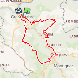
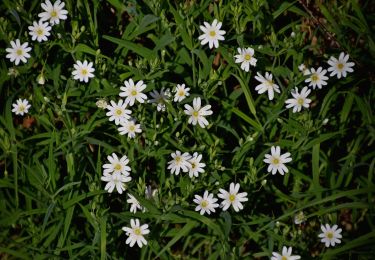
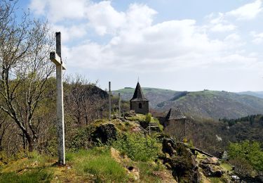
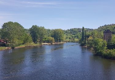
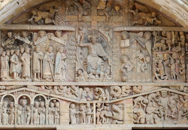
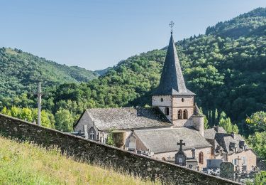
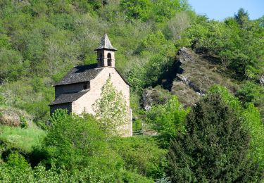
Cette superbe mais très longue randonnée fait un peu plus de 20 km et présente un dénivelé assez important. Départ de Grand-Vabre ou de Conques, nous avons pris la première solution pour des raisons de stationnement. Il faut compter 7H00 de marche, si vous flânez un peu à Conques, comptez une bonne heure de plus.
Localisation
Commentaires
Randonnées à proximité
![Randonnée Marche Conques-en-Rouergue - Les Pelies La Vinzelle : boucle rapide - Photo](https://media.geolcdn.com/t/375/260/ext.jpg?maxdim=2&url=https%3A%2F%2Fservices.sitytrail.com%2FGeolivesWS%2FDownloadMedia.ashx%3FTrailID%3D815525%26Media%3D20170822112933.jpg)
![Marche Marche](https://static1.geolcdn.com/sitytour/trail-icons/101.png)
Marche
![](/images/other/stat-length.png)
![](https://static1.geolcdn.com/siteimages/upload/files/16400158638029165_repeat_loop_refresh_sync_direction_icon.png)
![Randonnée Marche Conques-en-Rouergue - La Vinzelle - Grand Vabre - Photo](https://media.geolcdn.com/t/375/260/ext.jpg?maxdim=2&url=https%3A%2F%2Fservices.sitytrail.com%2FGeolivesWS%2FDownloadMedia.ashx%3FTrailID%3D107259%26Media%3D12139_6.jpg)
![Marche Marche](https://static1.geolcdn.com/sitytour/trail-icons/101.png)
Marche
![](/images/other/stat-length.png)
![](https://static1.geolcdn.com/siteimages/upload/files/16400158638029165_repeat_loop_refresh_sync_direction_icon.png)
![Randonnée A pied Conques-en-Rouergue - TerraTrail 7 - Photo](https://media.geolcdn.com/t/375/260/a3c72d09-9e84-4bb5-99d1-f393f2772e29.jpeg&format=jpg&maxdim=2)
![A pied A pied](https://static1.geolcdn.com/sitytour/trail-icons/100.png)
A pied
![](/images/other/stat-length.png)
![](https://static1.geolcdn.com/siteimages/upload/files/16400158638029165_repeat_loop_refresh_sync_direction_icon.png)
![Randonnée A pied Conques-en-Rouergue - Terra trail 10 - Photo](https://media.geolcdn.com/t/375/260/c1627d11-6231-43ca-9a1f-6c8b11a3fcd5.jpeg&format=jpg&maxdim=2)
![A pied A pied](https://static1.geolcdn.com/sitytour/trail-icons/100.png)
A pied
![](/images/other/stat-length.png)
![](https://static1.geolcdn.com/siteimages/upload/files/16400158638029165_repeat_loop_refresh_sync_direction_icon.png)
![Randonnée Marche Conques-en-Rouergue - Conques Levinhac le Haut Avril 2018 - Photo](https://media.geolcdn.com/t/375/260/ext.jpg?maxdim=2&url=https%3A%2F%2Fservices.sitytrail.com%2FGeolivesWS%2FDownloadMedia.ashx%3FTrailID%3D954999%26Media%3Dfix__20180426142306.jpg)
![Marche Marche](https://static1.geolcdn.com/sitytour/trail-icons/101.png)
Marche
![](/images/other/stat-length.png)
![](https://static1.geolcdn.com/siteimages/upload/files/16400158638029165_repeat_loop_refresh_sync_direction_icon.png)
![Randonnée Marche Conques-en-Rouergue - Conques - Photo](https://media.geolcdn.com/t/375/260/b1ba52c1-bc17-4a66-9751-be2d2d70e0b7.jpg&format=jpg&maxdim=2)
![Marche Marche](https://static1.geolcdn.com/sitytour/trail-icons/101.png)
Marche
![](/images/other/stat-length.png)
![](https://static1.geolcdn.com/siteimages/upload/files/16400158638029165_repeat_loop_refresh_sync_direction_icon.png)
![Randonnée A pied Conques-en-Rouergue - Sentier Conques - Grand-Vabre - Photo](https://media.geolcdn.com/t/375/260/54393b8a-3c65-496a-ad24-69e3b20f1258.jpeg&format=jpg&maxdim=2)
![A pied A pied](https://static1.geolcdn.com/sitytour/trail-icons/100.png)
A pied
![](/images/other/stat-length.png)
![](https://static1.geolcdn.com/siteimages/upload/files/16400158638029165_repeat_loop_refresh_sync_direction_icon.png)
![Randonnée A pied Conques-en-Rouergue - Tieulet - Photo](https://media.geolcdn.com/t/375/260/81ea3ff4-8db3-4406-ab2f-734b1935602f.jpeg&format=jpg&maxdim=2)
![A pied A pied](https://static1.geolcdn.com/sitytour/trail-icons/100.png)
A pied
![](/images/other/stat-length.png)
![](https://static1.geolcdn.com/siteimages/upload/files/16400158638029165_repeat_loop_refresh_sync_direction_icon.png)
![Randonnée A pied Conques-en-Rouergue - Chapelle Sainte-Foy - Photo](https://media.geolcdn.com/t/375/260/434a867d-228b-48bc-b18b-156cab88645d.jpeg&format=jpg&maxdim=2)
![A pied A pied](https://static1.geolcdn.com/sitytour/trail-icons/100.png)
A pied
![](/images/other/stat-length.png)
![](https://static1.geolcdn.com/siteimages/upload/files/16400158638029165_repeat_loop_refresh_sync_direction_icon.png)