![](/images/other/stat-length.png)
![Randonnée V.T.T. Villerest - Cheminons à Villerest et à VTT - Photo](https://media.geolcdn.com/t/1900/400/ext.pjpeg?maxdim=2&url=https%3A%2F%2Fservices.sitytrail.com%2FGeolivesWS%2FDownloadMedia.ashx%3FTrailID%3D107186%26Media%3D12038_6.jpg)
Cheminons à Villerest et à VTT
tracegps
Utilisateur
![Longueur](/images/other/stat-length.png)
![Altitude max](https://static1.geolcdn.com/siteimages/upload/files/1508320355ic_sort_altitude_max_24dp.png)
![Dénivelé positif](https://static1.geolcdn.com/siteimages/upload/files/1508320355ic_sort_den_pos_24dp.png)
![Km-Effort](/images/other/stat-length.png)
![Altitude min](https://static1.geolcdn.com/siteimages/upload/files/1508320355ic_sort_altitude_min_24dp.png)
![Dénivelé négatif](https://static1.geolcdn.com/siteimages/upload/files/1508320355ic_sort_den_neg_24dp.png)
![Boucle](https://static1.geolcdn.com/siteimages/upload/files/16400158638029165_repeat_loop_refresh_sync_direction_icon.png)
![V.T.T.](https://static1.geolcdn.com/sitytour/trail-icons/202.png)
2h00
Difficulté : Très difficile
![Scannez ce code QR pour ouvrir la randonnée dans l'application SityTrail](https://capi.geolives.com/qq0zvz2zws4bq2lad0pu/sitytour/trails/107186/qr.png?size=200)
Application GPS de randonnée GRATUITE
À propos
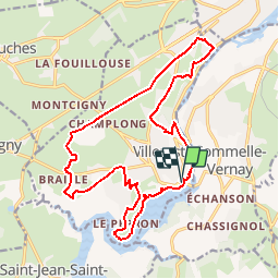
Randonnée V.T.T. de 19,3 km à découvrir à Auvergne-Rhône-Alpes, Loire, Villerest. Cette randonnée est proposée par tracegps.
Description
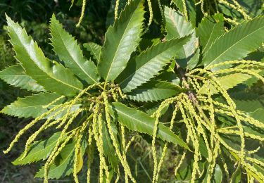
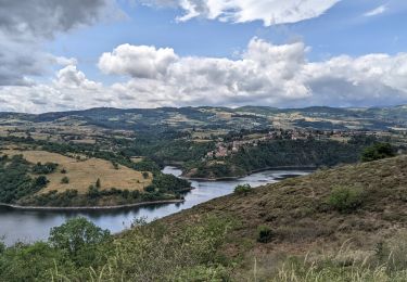
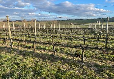
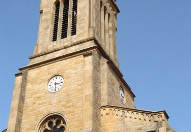
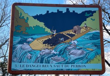
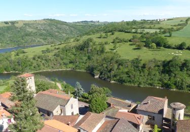
Parking et départ du barrage de Villerest (au pied du club de la "Pétanque sportive"). Ce parcours, peu connu, est une alternative intéressante aux tracés balisés de Grand Roanne Agglomération N° 7 et 8 et permet aussi de découvrir le patrimoine et les points remarquables de Villerest et de ses alentours. Le balisage à l'aide de fers à cheval de couleur bleu, jaune et vert est une bonne idée mais il est malheureusement très aléatoire... La réalisation de ces circuits a été possible grâce à l'accord de propriétaires privés, respectez ces lieux en n'empruntant que les chemins balisés. J'ai classé la difficulté de ce parcours en "noir" car tout ne passe pas sur le VTT, il y a de courtes portions montantes ou descendantes assez escarpées où il faut mettre le pied à terre, mais globalement c'est plutôt du "Bleu" pour les VTTistes confirmés ! Topoguides : cette boucle est inspirée du rando-guide gratuit "Cheminons à Villerest" (6 circuits de randonnée). Topo-guide du Grand Roanne Agglomération, de balades en découvertes, disponible à l'O.T de Roanne. Randonnée entre Loire et Rhône de la CoPLER (Communauté de Commune du Pays entre Loire et Rhône), disponible à l'OT/SI de St Symphorien de Lay.
Localisation
Commentaires
Randonnées à proximité
![Randonnée V.T.T. Commelle-Vernay - VTT dans le bois de Terrenoire et au bord du Rhins - Commelle Vernay - Photo](https://media.geolcdn.com/t/375/260/ext.jpg?maxdim=2&url=https%3A%2F%2Fservices.sitytrail.com%2FGeolivesWS%2FDownloadMedia.ashx%3FTrailID%3D318053%26Media%3D17525_4.jpg)
![V.T.T. V.T.T.](https://static1.geolcdn.com/sitytour/trail-icons/202.png)
V.T.T.
![](/images/other/stat-length.png)
![](https://static1.geolcdn.com/siteimages/upload/files/16400158638029165_repeat_loop_refresh_sync_direction_icon.png)
![Randonnée Marche Saint-Jean-Saint-Maurice-sur-Loire - Autour des Gorges de la Loire - PR N° 9 : Sur le pas des pèlerins - Saint-Jean-Saint-Maurice-sur-Loire - Photo](https://media.geolcdn.com/t/375/260/ext.jpg?maxdim=2&url=https%3A%2F%2Fservices.sitytrail.com%2FGeolivesWS%2FDownloadMedia.ashx%3FTrailID%3D215167%26Media%3D15769_6.jpg)
![Marche Marche](https://static1.geolcdn.com/sitytour/trail-icons/101.png)
Marche
![](/images/other/stat-length.png)
![](https://static1.geolcdn.com/siteimages/upload/files/16400158638029165_repeat_loop_refresh_sync_direction_icon.png)
![Randonnée Marche Saint-Jean-Saint-Maurice-sur-Loire - Saint -Jean Saint -Maurice sur Loire - Photo](https://media.geolcdn.com/t/375/260/1053c594-4557-4a01-9659-5504d28a00d0.jpg&format=jpg&maxdim=2)
![Marche Marche](https://static1.geolcdn.com/sitytour/trail-icons/101.png)
Marche
![](/images/other/stat-length.png)
![](https://static1.geolcdn.com/siteimages/upload/files/16400158638029165_repeat_loop_refresh_sync_direction_icon.png)
![Randonnée Marche Saint-Cyr-de-Favières - Cordelle : Bois de Terrenoire - Photo](https://media.geolcdn.com/t/375/260/83c50546-4cae-443c-a80b-cd81d4b0f56f.jpg&format=jpg&maxdim=2)
![Marche Marche](https://static1.geolcdn.com/sitytour/trail-icons/101.png)
Marche
![](/images/other/stat-length.png)
![](https://static1.geolcdn.com/siteimages/upload/files/16400158638029165_repeat_loop_refresh_sync_direction_icon.png)
![Randonnée Marche Cordelle - boucle rilly-9.7 km - Photo](https://media.geolcdn.com/t/375/260/70cbec56-e75d-4971-a31c-1db03be10e15.jpg&format=jpg&maxdim=2)
![Marche Marche](https://static1.geolcdn.com/sitytour/trail-icons/101.png)
Marche
![](/images/other/stat-length.png)
![](https://static1.geolcdn.com/siteimages/upload/files/16400158638029165_repeat_loop_refresh_sync_direction_icon.png)
![Randonnée Marche Ouches - Ouches : de la plaine à la côte roannaise - Photo](https://media.geolcdn.com/t/375/260/6b9e8121-0a01-4791-9e45-beccd7d62b78.jpg&format=jpg&maxdim=2)
![Marche Marche](https://static1.geolcdn.com/sitytour/trail-icons/101.png)
Marche
![](/images/other/stat-length.png)
![](https://static1.geolcdn.com/siteimages/upload/files/16400158638029165_repeat_loop_refresh_sync_direction_icon.png)
![Randonnée Marche Cordelle - Cordelle : Terrenoire et versant sud - Photo](https://media.geolcdn.com/t/375/260/dfd1ec12-e45d-43ae-9a56-cd1f4a318fa5.jpg&format=jpg&maxdim=2)
![Marche Marche](https://static1.geolcdn.com/sitytour/trail-icons/101.png)
Marche
![](/images/other/stat-length.png)
![](https://static1.geolcdn.com/siteimages/upload/files/16400158638029165_repeat_loop_refresh_sync_direction_icon.png)
![Randonnée A pied Commelle-Vernay - Commelle-Vernay : petit train touristique - Photo](https://media.geolcdn.com/t/375/260/25e5a88d-0a40-4783-a608-61f5fa58e2c4.jpg&format=jpg&maxdim=2)
![A pied A pied](https://static1.geolcdn.com/sitytour/trail-icons/100.png)
A pied
![](/images/other/stat-length.png)
![](https://static1.geolcdn.com/siteimages/upload/files/16400158638029165_repeat_loop_refresh_sync_direction_icon.png)
![Randonnée Marche Saint-Jean-Saint-Maurice-sur-Loire - St Jean-St Maurice 18km - Photo](https://media.geolcdn.com/t/375/260/930956ea-3504-4ab8-b415-5247c26b90ff.jpg&format=jpg&maxdim=2)
![Marche Marche](https://static1.geolcdn.com/sitytour/trail-icons/101.png)
Marche
![](/images/other/stat-length.png)
![](https://static1.geolcdn.com/siteimages/upload/files/16400158638029165_repeat_loop_refresh_sync_direction_icon.png)