![](/images/other/stat-length.png)
![Randonnée Marche Saint-Aubin-de-Crétot - St Aubin de Crétot - Photo](https://media.geolcdn.com/t/1900/400/ext.pjpeg?maxdim=2&url=https%3A%2F%2Fservices.sitytrail.com%2FGeolivesWS%2FDownloadMedia.ashx%3FTrailID%3D107050%26Media%3D11860_1.jpg)
St Aubin de Crétot
tracegps
Utilisateur
![Longueur](/images/other/stat-length.png)
Longueur
17,8 km
![Altitude max](https://static1.geolcdn.com/siteimages/upload/files/1508320355ic_sort_altitude_max_24dp.png)
Altitude max
148 m
![Dénivelé positif](https://static1.geolcdn.com/siteimages/upload/files/1508320355ic_sort_den_pos_24dp.png)
Dénivelé positif
356 m
![Km-Effort](/images/other/stat-length.png)
Km-Effort
23 km
![Altitude min](https://static1.geolcdn.com/siteimages/upload/files/1508320355ic_sort_altitude_min_24dp.png)
Altitude min
26 m
![Dénivelé négatif](https://static1.geolcdn.com/siteimages/upload/files/1508320355ic_sort_den_neg_24dp.png)
Dénivelé négatif
351 m
![Boucle](https://static1.geolcdn.com/siteimages/upload/files/16400158638029165_repeat_loop_refresh_sync_direction_icon.png)
Boucle
Non
Date de création :
2014-12-10 00:00:00.0
Dernière modification :
2014-12-10 00:00:00.0
![Marche](https://static1.geolcdn.com/sitytour/trail-icons/101.png)
3h40
Difficulté : Moyen
![Scannez ce code QR pour ouvrir la randonnée dans l'application SityTrail](https://capi.geolives.com/qq0zvz2zws4bq2lad0pu/sitytour/trails/107050/qr.png?size=200)
Application GPS de randonnée GRATUITE
À propos
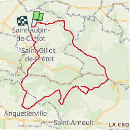
Randonnée Marche de 17,8 km à découvrir à Normandie, Seine-Maritime, Saint-Aubin-de-Crétot. Cette randonnée est proposée par tracegps.
Description
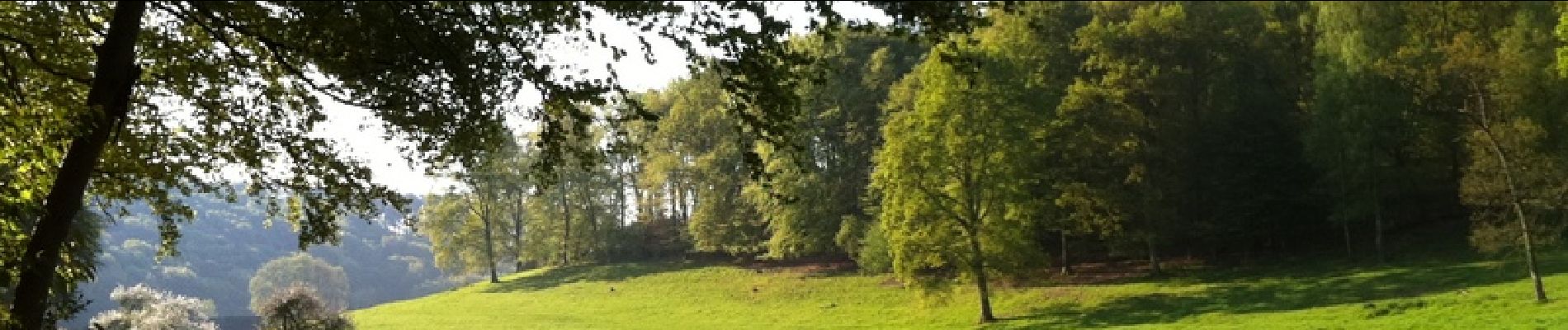
Un balade très agréable où alternent les dénivelés qui découvrent les paysages de la campagne du pays de Caux et ceux de la forêt domaniale du Trait-Maulévrier.
Localisation
Pays :
France
Région :
Normandie
Département/Province :
Seine-Maritime
Commune :
Saint-Aubin-de-Crétot
Localité :
Unknown
Départ:(Dec)
Départ:(UTM)
329250 ; 5493511 (31U) N.
Commentaires
Randonnées à proximité
![Randonnée Marche Allouville-Bellefosse - allouille bellefosse - Photo](https://media.geolcdn.com/t/375/260/ext.jpg?maxdim=2&url=https%3A%2F%2Fstatic1.geolcdn.com%2Fsiteimages%2Fupload%2Ffiles%2F1553511878bg_sport_marche.png)
![Marche Marche](https://static1.geolcdn.com/sitytour/trail-icons/101.png)
allouille bellefosse
Marche
Très facile
(2)
Allouville-Bellefosse,
Normandie,
Seine-Maritime,
France
![](/images/other/stat-length.png)
10,4 km | 12,6 km-effort
2h 30min
![](https://static1.geolcdn.com/siteimages/upload/files/16400158638029165_repeat_loop_refresh_sync_direction_icon.png)
Oui
![Randonnée Marche Allouville-Bellefosse - Allouville -Bellefosse - Photo](https://media.geolcdn.com/t/375/260/48ea2f08-2bb6-4cc5-be17-998a80c9c4f7.jpg&format=jpg&maxdim=2)
![Marche Marche](https://static1.geolcdn.com/sitytour/trail-icons/101.png)
Allouville -Bellefosse
Marche
Difficile
(1)
Allouville-Bellefosse,
Normandie,
Seine-Maritime,
France
![](/images/other/stat-length.png)
10,3 km | 12,5 km-effort
2h 52min
![](https://static1.geolcdn.com/siteimages/upload/files/16400158638029165_repeat_loop_refresh_sync_direction_icon.png)
Oui
![Randonnée Marche Maulévrier-Sainte-Gertrude - Maulévrier-Sainte-Gertrude (144) - Photo](https://media.geolcdn.com/t/375/260/ext.jpg?maxdim=2&url=https%3A%2F%2Fstatic1.geolcdn.com%2Fsiteimages%2Fupload%2Ffiles%2F1553511878bg_sport_marche.png)
![Marche Marche](https://static1.geolcdn.com/sitytour/trail-icons/101.png)
Maulévrier-Sainte-Gertrude (144)
Marche
Difficile
Maulévrier-Sainte-Gertrude,
Normandie,
Seine-Maritime,
France
![](/images/other/stat-length.png)
12,1 km | 17,1 km-effort
3h 53min
![](https://static1.geolcdn.com/siteimages/upload/files/16400158638029165_repeat_loop_refresh_sync_direction_icon.png)
Oui
![Randonnée Marche Allouville-Bellefosse - Allouville Bellefosse 25/08/2024 - Photo](https://media.geolcdn.com/t/375/260/ext.jpg?maxdim=2&url=https%3A%2F%2Fstatic1.geolcdn.com%2Fsiteimages%2Fupload%2Ffiles%2F1553511878bg_sport_marche.png)
![Marche Marche](https://static1.geolcdn.com/sitytour/trail-icons/101.png)
Allouville Bellefosse 25/08/2024
Marche
Difficile
Allouville-Bellefosse,
Normandie,
Seine-Maritime,
France
![](/images/other/stat-length.png)
10,6 km | 12,8 km-effort
2h 54min
![](https://static1.geolcdn.com/siteimages/upload/files/16400158638029165_repeat_loop_refresh_sync_direction_icon.png)
Oui
![Randonnée Marche Maulévrier-Sainte-Gertrude - ste gertrude - Photo](https://media.geolcdn.com/t/375/260/ext.jpg?maxdim=2&url=https%3A%2F%2Fstatic1.geolcdn.com%2Fsiteimages%2Fupload%2Ffiles%2F1553511878bg_sport_marche.png)
![Marche Marche](https://static1.geolcdn.com/sitytour/trail-icons/101.png)
ste gertrude
Marche
Très facile
Maulévrier-Sainte-Gertrude,
Normandie,
Seine-Maritime,
France
![](/images/other/stat-length.png)
7,1 km | 10,4 km-effort
2h 22min
![](https://static1.geolcdn.com/siteimages/upload/files/16400158638029165_repeat_loop_refresh_sync_direction_icon.png)
Oui
![Randonnée A pied Saint-Gilles-de-Crétot - Saint Gilles de Crétot - Photo](https://media.geolcdn.com/t/375/260/ext.jpg?maxdim=2&url=https%3A%2F%2Fstatic1.geolcdn.com%2Fsiteimages%2Fupload%2Ffiles%2F1545311037marcheuse_200dpi.jpg)
![A pied A pied](https://static1.geolcdn.com/sitytour/trail-icons/100.png)
Saint Gilles de Crétot
A pied
Facile
Saint-Gilles-de-Crétot,
Normandie,
Seine-Maritime,
France
![](/images/other/stat-length.png)
6,1 km | 7,5 km-effort
1h 30min
![](https://static1.geolcdn.com/siteimages/upload/files/16400158638029165_repeat_loop_refresh_sync_direction_icon.png)
Oui
![Randonnée A pied Allouville-Bellefosse - Le Chêne d'Allouville - Photo](https://media.geolcdn.com/t/375/260/ext.jpg?maxdim=2&url=https%3A%2F%2Fstatic1.geolcdn.com%2Fsiteimages%2Fupload%2Ffiles%2F1545311037marcheuse_200dpi.jpg)
![A pied A pied](https://static1.geolcdn.com/sitytour/trail-icons/100.png)
Le Chêne d'Allouville
A pied
Facile
Allouville-Bellefosse,
Normandie,
Seine-Maritime,
France
![](/images/other/stat-length.png)
10,2 km | 11,9 km-effort
2h 30min
![](https://static1.geolcdn.com/siteimages/upload/files/16400158638029165_repeat_loop_refresh_sync_direction_icon.png)
Oui
![Randonnée Marche Maulévrier-Sainte-Gertrude - GR-Le Chêne Saint Pierre - Photo](https://media.geolcdn.com/t/375/260/ext.jpg?maxdim=2&url=https%3A%2F%2Fstatic1.geolcdn.com%2Fsiteimages%2Fupload%2Ffiles%2F1553511878bg_sport_marche.png)
![Marche Marche](https://static1.geolcdn.com/sitytour/trail-icons/101.png)
GR-Le Chêne Saint Pierre
Marche
Difficile
(1)
Maulévrier-Sainte-Gertrude,
Normandie,
Seine-Maritime,
France
![](/images/other/stat-length.png)
9,6 km | 13,3 km-effort
3h 0min
![](https://static1.geolcdn.com/siteimages/upload/files/16400158638029165_repeat_loop_refresh_sync_direction_icon.png)
Oui
![Randonnée Marche Maulévrier-Sainte-Gertrude - PR-Le Chêne Saint Pierre - Photo](https://media.geolcdn.com/t/375/260/ext.jpg?maxdim=2&url=https%3A%2F%2Fstatic1.geolcdn.com%2Fsiteimages%2Fupload%2Ffiles%2F1553511878bg_sport_marche.png)
![Marche Marche](https://static1.geolcdn.com/sitytour/trail-icons/101.png)
PR-Le Chêne Saint Pierre
Marche
Moyen
Maulévrier-Sainte-Gertrude,
Normandie,
Seine-Maritime,
France
![](/images/other/stat-length.png)
7,2 km | 9,9 km-effort
2h 30min
![](https://static1.geolcdn.com/siteimages/upload/files/16400158638029165_repeat_loop_refresh_sync_direction_icon.png)
Oui