![](/images/other/stat-length.png)
![Randonnée Course à pied Castres - Boucle de la Parulle - Castres - Photo](https://media.geolcdn.com/t/1900/400/ext.pjpeg?maxdim=2&url=https%3A%2F%2Fstatic1.geolcdn.com%2Fsiteimages%2Fupload%2Ffiles%2F1524743154running.jpg)
Boucle de la Parulle - Castres
tracegps
Utilisateur
![Longueur](/images/other/stat-length.png)
Longueur
7,2 km
![Altitude max](https://static1.geolcdn.com/siteimages/upload/files/1508320355ic_sort_altitude_max_24dp.png)
Altitude max
300 m
![Dénivelé positif](https://static1.geolcdn.com/siteimages/upload/files/1508320355ic_sort_den_pos_24dp.png)
Dénivelé positif
181 m
![Km-Effort](/images/other/stat-length.png)
Km-Effort
9,6 km
![Altitude min](https://static1.geolcdn.com/siteimages/upload/files/1508320355ic_sort_altitude_min_24dp.png)
Altitude min
193 m
![Dénivelé négatif](https://static1.geolcdn.com/siteimages/upload/files/1508320355ic_sort_den_neg_24dp.png)
Dénivelé négatif
181 m
![Boucle](https://static1.geolcdn.com/siteimages/upload/files/16400158638029165_repeat_loop_refresh_sync_direction_icon.png)
Boucle
Oui
Date de création :
2014-12-10 00:00:00.0
Dernière modification :
2014-12-10 00:00:00.0
![Course à pied](https://static1.geolcdn.com/sitytour/trail-icons/103.png)
40m
Difficulté : Moyen
![Scannez ce code QR pour ouvrir la randonnée dans l'application SityTrail](https://capi.geolives.com/qq0zvz2zws4bq2lad0pu/sitytour/trails/107030/qr.png?size=200)
Application GPS de randonnée GRATUITE
À propos
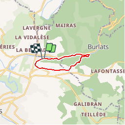
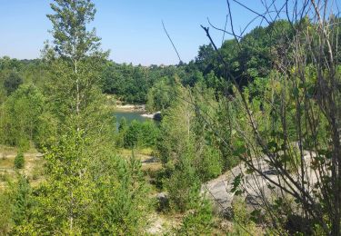
Randonnée Course à pied de 7,2 km à découvrir à Occitanie, Tarn, Castres. Cette randonnée est proposée par tracegps.
Description
Boucle empruntant le chemin des Fontaines et longeant sur une partie du parcours l'Agout. Certaines portions du chemin sont à pratiquer par temps sec.
Localisation
Pays :
France
Région :
Occitanie
Département/Province :
Tarn
Commune :
Castres
Localité :
Unknown
Départ:(Dec)
Départ:(UTM)
441927 ; 4831040 (31T) N.
Commentaires
Randonnées à proximité
![Randonnée A pied Burlats - Chemin des Fontaines - Photo](https://media.geolcdn.com/t/375/260/0fdbf2bb-361d-42f2-bb88-a8b62041bc5e.jpeg&format=jpg&maxdim=2)
![A pied A pied](https://static1.geolcdn.com/sitytour/trail-icons/100.png)
Chemin des Fontaines
A pied
Facile
Burlats,
Occitanie,
Tarn,
France
![](/images/other/stat-length.png)
7,3 km | 8,5 km-effort
1h 55min
![](https://static1.geolcdn.com/siteimages/upload/files/16400158638029165_repeat_loop_refresh_sync_direction_icon.png)
Non
![Randonnée Marche Burlats - Burlats cascade de la truite - Photo](https://media.geolcdn.com/t/375/260/9661be44-d4ff-4a36-943e-6669881f3e44.jpg&format=jpg&maxdim=2)
![Marche Marche](https://static1.geolcdn.com/sitytour/trail-icons/101.png)
Burlats cascade de la truite
Marche
Moyen
Burlats,
Occitanie,
Tarn,
France
![](/images/other/stat-length.png)
19,3 km | 30 km-effort
5h 22min
![](https://static1.geolcdn.com/siteimages/upload/files/16400158638029165_repeat_loop_refresh_sync_direction_icon.png)
Non
![Randonnée Marche Burlats - billets l'Agout 18kms 577m 4h30 - Photo](https://media.geolcdn.com/t/375/260/ext.jpg?maxdim=2&url=https%3A%2F%2Fservices.sitytrail.com%2FGeolivesWS%2FDownloadMedia.ashx%3FTrailID%3D1025519%26Media%3Dfix__20180819134756.jpg)
![Marche Marche](https://static1.geolcdn.com/sitytour/trail-icons/101.png)
billets l'Agout 18kms 577m 4h30
Marche
Facile
Burlats,
Occitanie,
Tarn,
France
![](/images/other/stat-length.png)
18,2 km | 25 km-effort
4h 44min
![](https://static1.geolcdn.com/siteimages/upload/files/16400158638029165_repeat_loop_refresh_sync_direction_icon.png)
Oui
![Randonnée V.T.T. Castres - 20141119_123639 - Photo](https://media.geolcdn.com/t/375/260/ext.jpg?maxdim=2&url=https%3A%2F%2Fstatic1.geolcdn.com%2Fsiteimages%2Fupload%2Ffiles%2F1524743154velo.jpg)
![V.T.T. V.T.T.](https://static1.geolcdn.com/sitytour/trail-icons/202.png)
20141119_123639
V.T.T.
Facile
(1)
Castres,
Occitanie,
Tarn,
France
![](/images/other/stat-length.png)
16,2 km | 21 km-effort
1h 35min
![](https://static1.geolcdn.com/siteimages/upload/files/16400158638029165_repeat_loop_refresh_sync_direction_icon.png)
Oui
![Randonnée Marche Castres - Castres - Dourgne - Photo](https://media.geolcdn.com/t/375/260/ext.jpg?maxdim=2&url=https%3A%2F%2Fservices.sitytrail.com%2FGeolivesWS%2FDownloadMedia.ashx%3FTrailID%3D185218%26Media%3D20130414160415.jpeg)
![Marche Marche](https://static1.geolcdn.com/sitytour/trail-icons/101.png)
![Randonnée Marche Burlats - Sidobre Castres - Photo](https://media.geolcdn.com/t/375/260/ext.jpg?maxdim=2&url=https%3A%2F%2Fstatic1.geolcdn.com%2Fsiteimages%2Fupload%2Ffiles%2F1553511878bg_sport_marche.png)
![Marche Marche](https://static1.geolcdn.com/sitytour/trail-icons/101.png)
![Randonnée Marche Burlats - Chaos de la Rouquette - Photo](https://media.geolcdn.com/t/375/260/ac313286-f0e8-4524-93a0-8abd2307e7b2.jpg&format=jpg&maxdim=2)
![Marche Marche](https://static1.geolcdn.com/sitytour/trail-icons/101.png)
Chaos de la Rouquette
Marche
Moyen
Burlats,
Occitanie,
Tarn,
France
![](/images/other/stat-length.png)
4,3 km | 5,8 km-effort
1h 9min
![](https://static1.geolcdn.com/siteimages/upload/files/16400158638029165_repeat_loop_refresh_sync_direction_icon.png)
Oui
![Randonnée Marche Burlats - Burlat - Photo](https://media.geolcdn.com/t/375/260/ext.jpg?maxdim=2&url=https%3A%2F%2Fstatic1.geolcdn.com%2Fsiteimages%2Fupload%2Ffiles%2F1553511878bg_sport_marche.png)
![Marche Marche](https://static1.geolcdn.com/sitytour/trail-icons/101.png)
![Randonnée Marche Roquecourbe - Roquecourbe Lacrouzette - Photo](https://media.geolcdn.com/t/375/260/ext.jpg?maxdim=2&url=https%3A%2F%2Fstatic1.geolcdn.com%2Fsiteimages%2Fupload%2Ffiles%2F1553511878bg_sport_marche.png)
![Marche Marche](https://static1.geolcdn.com/sitytour/trail-icons/101.png)
Roquecourbe Lacrouzette
Marche
Moyen
Roquecourbe,
Occitanie,
Tarn,
France
![](/images/other/stat-length.png)
27 km | 38 km-effort
8h 12min
![](https://static1.geolcdn.com/siteimages/upload/files/16400158638029165_repeat_loop_refresh_sync_direction_icon.png)
Oui