![](/images/other/stat-length.png)
![Randonnée Marche Bardigues - Circuit Cadillac - Bardigues - Photo](https://media.geolcdn.com/t/1900/400/ext.pjpeg?maxdim=2&url=https%3A%2F%2Fstatic1.geolcdn.com%2Fsiteimages%2Fupload%2Ffiles%2F1553511878bg_sport_marche.png)
Circuit Cadillac - Bardigues
tracegps
Utilisateur
![Longueur](/images/other/stat-length.png)
Longueur
4,7 km
![Altitude max](https://static1.geolcdn.com/siteimages/upload/files/1508320355ic_sort_altitude_max_24dp.png)
Altitude max
165 m
![Dénivelé positif](https://static1.geolcdn.com/siteimages/upload/files/1508320355ic_sort_den_pos_24dp.png)
Dénivelé positif
62 m
![Km-Effort](/images/other/stat-length.png)
Km-Effort
5,5 km
![Altitude min](https://static1.geolcdn.com/siteimages/upload/files/1508320355ic_sort_altitude_min_24dp.png)
Altitude min
131 m
![Dénivelé négatif](https://static1.geolcdn.com/siteimages/upload/files/1508320355ic_sort_den_neg_24dp.png)
Dénivelé négatif
63 m
![Boucle](https://static1.geolcdn.com/siteimages/upload/files/16400158638029165_repeat_loop_refresh_sync_direction_icon.png)
Boucle
Oui
Date de création :
2014-12-10 00:00:00.0
Dernière modification :
2014-12-10 00:00:00.0
![Marche](https://static1.geolcdn.com/sitytour/trail-icons/101.png)
1h30
Difficulté : Moyen
![Scannez ce code QR pour ouvrir la randonnée dans l'application SityTrail](https://capi.geolives.com/qq0zvz2zws4bq2lad0pu/sitytour/trails/106810/qr.png?size=200)
Application GPS de randonnée GRATUITE
À propos
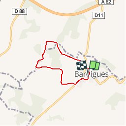
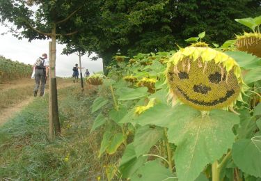
Randonnée Marche de 4,7 km à découvrir à Occitanie, Tarn-et-Garonne, Bardigues. Cette randonnée est proposée par tracegps.
Description
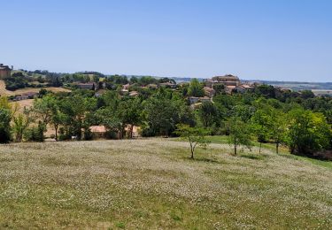
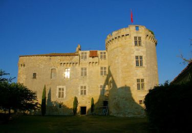
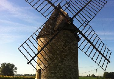
Départ de Bardigues pour une randonnée en boucle autour du château de la Motte, propriété privée, mais que l’on peut apercevoir de loin.
Localisation
Pays :
France
Région :
Occitanie
Département/Province :
Tarn-et-Garonne
Commune :
Bardigues
Localité :
Unknown
Départ:(Dec)
Départ:(UTM)
330854 ; 4878507 (31T) N.
Commentaires
Randonnées à proximité
![Randonnée Marche Auvillar - auvillar mirandoux - Photo](https://media.geolcdn.com/t/375/260/ext.jpg?maxdim=2&url=https%3A%2F%2Fmedia.geolcdn.com%2Ff%2F6f195b95-5de6-4c93-9d2d-fc2a6ae4f795.jpg)
![Marche Marche](https://static1.geolcdn.com/sitytour/trail-icons/101.png)
auvillar mirandoux
Marche
Moyen
Auvillar,
Occitanie,
Tarn-et-Garonne,
France
![](/images/other/stat-length.png)
17,3 km | 23 km-effort
4h 26min
![](https://static1.geolcdn.com/siteimages/upload/files/16400158638029165_repeat_loop_refresh_sync_direction_icon.png)
Non
![Randonnée Marche Saint-Antoine - CC_Velay_EC_19_St-Antoine_Lectoure_20080819 - Photo](https://media.geolcdn.com/t/375/260/ext.jpg?maxdim=2&url=https%3A%2F%2Fmedia.geolcdn.com%2Ff%2F503b802f-d1d4-4655-ab44-f8a583414d3a.JPG)
![Marche Marche](https://static1.geolcdn.com/sitytour/trail-icons/101.png)
CC_Velay_EC_19_St-Antoine_Lectoure_20080819
Marche
Moyen
Saint-Antoine,
Occitanie,
Gers,
France
![](/images/other/stat-length.png)
25 km | 32 km-effort
6h 53min
![](https://static1.geolcdn.com/siteimages/upload/files/16400158638029165_repeat_loop_refresh_sync_direction_icon.png)
Non
![Randonnée Marche Saint-Antoine - Saint Antoine - Lectoure - Chemin de Compostelle - Photo](https://media.geolcdn.com/t/375/260/ext.jpg?maxdim=2&url=https%3A%2F%2Fservices.sitytrail.com%2FGeolivesWS%2FDownloadMedia.ashx%3FTrailID%3D109608%26Media%3D4218_3.jpg)
![Marche Marche](https://static1.geolcdn.com/sitytour/trail-icons/101.png)
Saint Antoine - Lectoure - Chemin de Compostelle
Marche
Très difficile
(1)
Saint-Antoine,
Occitanie,
Gers,
France
![](/images/other/stat-length.png)
24 km | 31 km-effort
9h 34min
![](https://static1.geolcdn.com/siteimages/upload/files/16400158638029165_repeat_loop_refresh_sync_direction_icon.png)
Non
![Randonnée Marche Auvillar - Circuit du Moulin - Auvillar les Peyrères - Photo](https://media.geolcdn.com/t/375/260/ext.jpg?maxdim=2&url=https%3A%2F%2Fservices.sitytrail.com%2FGeolivesWS%2FDownloadMedia.ashx%3FTrailID%3D106812%26Media%3D11512_1.jpg)
![Marche Marche](https://static1.geolcdn.com/sitytour/trail-icons/101.png)
Circuit du Moulin - Auvillar les Peyrères
Marche
Moyen
Auvillar,
Occitanie,
Tarn-et-Garonne,
France
![](/images/other/stat-length.png)
6,7 km | 8,3 km-effort
1h 30min
![](https://static1.geolcdn.com/siteimages/upload/files/16400158638029165_repeat_loop_refresh_sync_direction_icon.png)
Oui
![Randonnée Marche Auvillar - Camino 1- étape 21 du 15.08.2023 - Photo](https://media.geolcdn.com/t/375/260/ext.jpg?maxdim=2&url=https%3A%2F%2Fstatic1.geolcdn.com%2Fsiteimages%2Fupload%2Ffiles%2F1553511878bg_sport_marche.png)
![Marche Marche](https://static1.geolcdn.com/sitytour/trail-icons/101.png)
Camino 1- étape 21 du 15.08.2023
Marche
Très difficile
Auvillar,
Occitanie,
Tarn-et-Garonne,
France
![](/images/other/stat-length.png)
35 km | 45 km-effort
22h 58min
![](https://static1.geolcdn.com/siteimages/upload/files/16400158638029165_repeat_loop_refresh_sync_direction_icon.png)
Non
![Randonnée Marche Auvillar - 5-Auvillar-Miradoux 18km - Photo](https://media.geolcdn.com/t/375/260/ext.jpg?maxdim=2&url=https%3A%2F%2Fstatic1.geolcdn.com%2Fsiteimages%2Fupload%2Ffiles%2F1553511878bg_sport_marche.png)
![Marche Marche](https://static1.geolcdn.com/sitytour/trail-icons/101.png)
5-Auvillar-Miradoux 18km
Marche
Moyen
Auvillar,
Occitanie,
Tarn-et-Garonne,
France
![](/images/other/stat-length.png)
17,7 km | 23 km-effort
5h 13min
![](https://static1.geolcdn.com/siteimages/upload/files/16400158638029165_repeat_loop_refresh_sync_direction_icon.png)
Non
![Randonnée Marche Bardigues - compostelle 2023 étape 9 le 27 avril 2023 Bardigues - Espasot - Photo](https://media.geolcdn.com/t/375/260/ext.jpg?maxdim=2&url=https%3A%2F%2Fstatic1.geolcdn.com%2Fsiteimages%2Fupload%2Ffiles%2F1553511878bg_sport_marche.png)
![Marche Marche](https://static1.geolcdn.com/sitytour/trail-icons/101.png)
compostelle 2023 étape 9 le 27 avril 2023 Bardigues - Espasot
Marche
Très difficile
Bardigues,
Occitanie,
Tarn-et-Garonne,
France
![](/images/other/stat-length.png)
35 km | 44 km-effort
9h 51min
![](https://static1.geolcdn.com/siteimages/upload/files/16400158638029165_repeat_loop_refresh_sync_direction_icon.png)
Non
![Randonnée Marche Saint-Antoine - 32_Castet_Arrouy - Photo](https://media.geolcdn.com/t/375/260/ext.jpg?maxdim=2&url=https%3A%2F%2Fstatic1.geolcdn.com%2Fsiteimages%2Fupload%2Ffiles%2F1553511878bg_sport_marche.png)
![Marche Marche](https://static1.geolcdn.com/sitytour/trail-icons/101.png)
32_Castet_Arrouy
Marche
Facile
Saint-Antoine,
Occitanie,
Gers,
France
![](/images/other/stat-length.png)
13,5 km | 17,7 km-effort
3h 51min
![](https://static1.geolcdn.com/siteimages/upload/files/16400158638029165_repeat_loop_refresh_sync_direction_icon.png)
Non
![Randonnée Marche Auvillar - auvillar - Photo](https://media.geolcdn.com/t/375/260/ext.jpg?maxdim=2&url=https%3A%2F%2Fstatic1.geolcdn.com%2Fsiteimages%2Fupload%2Ffiles%2F1553511878bg_sport_marche.png)
![Marche Marche](https://static1.geolcdn.com/sitytour/trail-icons/101.png)
auvillar
Marche
Très facile
Auvillar,
Occitanie,
Tarn-et-Garonne,
France
![](/images/other/stat-length.png)
16,5 km | 21 km-effort
4h 37min
![](https://static1.geolcdn.com/siteimages/upload/files/16400158638029165_repeat_loop_refresh_sync_direction_icon.png)
Oui