![](/images/other/stat-length.png)
![Randonnée V.T.T. Chambon-sur-Lac - Espace VTT FFC du Sancy - Circuit n°06 - Les Angles - Secteur Chambon sur Lac - Photo](https://media.geolcdn.com/t/1900/400/ext.pjpeg?maxdim=2&url=https%3A%2F%2Fservices.sitytrail.com%2FGeolivesWS%2FDownloadMedia.ashx%3FTrailID%3D106750%26Media%3D11417_4.jpg)
Espace VTT FFC du Sancy - Circuit n°06 - Les Angles - Secteur Chambon sur Lac
tracegps
Utilisateur
![Longueur](/images/other/stat-length.png)
![Altitude max](https://static1.geolcdn.com/siteimages/upload/files/1508320355ic_sort_altitude_max_24dp.png)
![Dénivelé positif](https://static1.geolcdn.com/siteimages/upload/files/1508320355ic_sort_den_pos_24dp.png)
![Km-Effort](/images/other/stat-length.png)
![Altitude min](https://static1.geolcdn.com/siteimages/upload/files/1508320355ic_sort_altitude_min_24dp.png)
![Dénivelé négatif](https://static1.geolcdn.com/siteimages/upload/files/1508320355ic_sort_den_neg_24dp.png)
![Boucle](https://static1.geolcdn.com/siteimages/upload/files/16400158638029165_repeat_loop_refresh_sync_direction_icon.png)
![V.T.T.](https://static1.geolcdn.com/sitytour/trail-icons/202.png)
49m
Difficulté : Difficile
![Scannez ce code QR pour ouvrir la randonnée dans l'application SityTrail](https://capi.geolives.com/qq0zvz2zws4bq2lad0pu/sitytour/trails/106750/qr.png?size=200)
Application GPS de randonnée GRATUITE
À propos
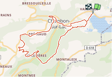
Randonnée V.T.T. de 11,5 km à découvrir à Auvergne-Rhône-Alpes, Puy-de-Dôme, Chambon-sur-Lac. Cette randonnée est proposée par tracegps.
Description
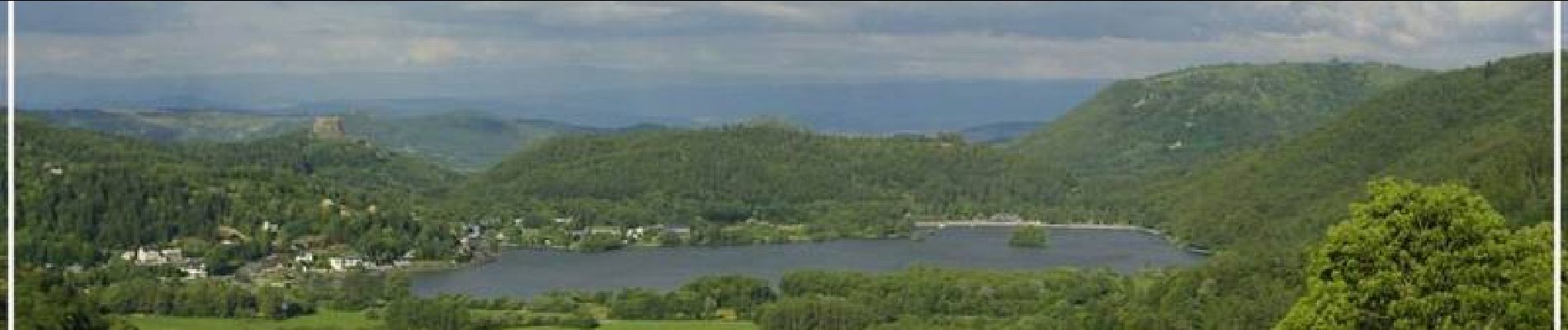
Espace VTT FFC du Sancy - Circuit n°06 - Les Angles - Secteur Chambon sur Lac Circuit officiel labellisé par la Fédération Française de Cyclisme. Départ de l’Office de Tourisme de Murol. Beau panoramique sur le château et la Vallée Verte. Circuit difficile et exigeant qui du Lac nous fait monter jusqu’à La Guièze.
Localisation
Commentaires
Randonnées à proximité
![Randonnée Marche Chambon-sur-Lac - Chambon_Couze_Surains - Photo](https://media.geolcdn.com/t/375/260/69ddf9d1-6553-4ac4-9be3-6827620eb27f.jpg&format=jpg&maxdim=2)
![Marche Marche](https://static1.geolcdn.com/sitytour/trail-icons/101.png)
Marche
![](/images/other/stat-length.png)
![](https://static1.geolcdn.com/siteimages/upload/files/16400158638029165_repeat_loop_refresh_sync_direction_icon.png)
![Randonnée Marche Le Vernet-Sainte-Marguerite - Vernet_Puy_Alou - Photo](https://media.geolcdn.com/t/375/260/a4ebea47-01be-4a97-870e-08908270dc48.jpg&format=jpg&maxdim=2)
![Marche Marche](https://static1.geolcdn.com/sitytour/trail-icons/101.png)
Marche
![](/images/other/stat-length.png)
![](https://static1.geolcdn.com/siteimages/upload/files/16400158638029165_repeat_loop_refresh_sync_direction_icon.png)
![Randonnée Marche Saint-Victor-la-Rivière - St_Victor_Foret_Courbanges - Photo](https://media.geolcdn.com/t/375/260/9fef1c83-9b6e-46fe-9ede-9513f0c587d7.jpg&format=jpg&maxdim=2)
![Marche Marche](https://static1.geolcdn.com/sitytour/trail-icons/101.png)
Marche
![](/images/other/stat-length.png)
![](https://static1.geolcdn.com/siteimages/upload/files/16400158638029165_repeat_loop_refresh_sync_direction_icon.png)
![Randonnée Marche Murol - Lac Chambon et château médiéval de Murol - Photo](https://media.geolcdn.com/t/375/260/ext.jpg?maxdim=2&url=https%3A%2F%2Fservices.sitytrail.com%2FGeolivesWS%2FDownloadMedia.ashx%3FTrailID%3D103434%26Media%3D5550_4.jpg)
![Marche Marche](https://static1.geolcdn.com/sitytour/trail-icons/101.png)
Marche
![](/images/other/stat-length.png)
![](https://static1.geolcdn.com/siteimages/upload/files/16400158638029165_repeat_loop_refresh_sync_direction_icon.png)
![Randonnée Marche Murol - Murol_Marais_Chambon - Photo](https://media.geolcdn.com/t/375/260/0f7a243a-9f85-491b-8248-bb99ca309e11.jpg&format=jpg&maxdim=2)
![Marche Marche](https://static1.geolcdn.com/sitytour/trail-icons/101.png)
Marche
![](/images/other/stat-length.png)
![](https://static1.geolcdn.com/siteimages/upload/files/16400158638029165_repeat_loop_refresh_sync_direction_icon.png)
![Randonnée Marche Chambon-sur-Lac - Chambon_Moneaux - Photo](https://media.geolcdn.com/t/375/260/460725f3-6d73-441e-a5c8-44b8d6b3875e.jpg&format=jpg&maxdim=2)
![Marche Marche](https://static1.geolcdn.com/sitytour/trail-icons/101.png)
Marche
![](/images/other/stat-length.png)
![](https://static1.geolcdn.com/siteimages/upload/files/16400158638029165_repeat_loop_refresh_sync_direction_icon.png)
![Marche Marche](https://static1.geolcdn.com/sitytour/trail-icons/101.png)
Marche
![](/images/other/stat-length.png)
![](https://static1.geolcdn.com/siteimages/upload/files/16400158638029165_repeat_loop_refresh_sync_direction_icon.png)
![Randonnée Cheval Murol - Murol - Montlosier 27km J7 - Photo](https://media.geolcdn.com/t/375/260/ext.jpg?maxdim=2&url=https%3A%2F%2Fstatic1.geolcdn.com%2Fsiteimages%2Fupload%2Ffiles%2F1524743154cheval.jpg)
![Cheval Cheval](https://static1.geolcdn.com/sitytour/trail-icons/300.png)
Cheval
![](/images/other/stat-length.png)
![](https://static1.geolcdn.com/siteimages/upload/files/16400158638029165_repeat_loop_refresh_sync_direction_icon.png)
![Randonnée A pied Chambon-sur-Lac - Voissière - Photo](https://media.geolcdn.com/t/375/260/ad5c25c1-8c05-4bf1-9bc1-fa593c4f28d3.jpeg&format=jpg&maxdim=2)
![A pied A pied](https://static1.geolcdn.com/sitytour/trail-icons/100.png)
A pied
![](/images/other/stat-length.png)
![](https://static1.geolcdn.com/siteimages/upload/files/16400158638029165_repeat_loop_refresh_sync_direction_icon.png)