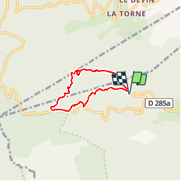
![](/images/other/stat-length.png)
![Randonnée Marche Chapareillan - Le chemin des charbonniers du Lac Noir - Les Marches - Photo](https://media.geolcdn.com/t/1900/400/ext.pjpeg?maxdim=2&url=https%3A%2F%2Fservices.sitytrail.com%2FGeolivesWS%2FDownloadMedia.ashx%3FTrailID%3D106686%26Media%3D11318_1.jpg)
Le chemin des charbonniers du Lac Noir - Les Marches
tracegps
Utilisateur
![Longueur](/images/other/stat-length.png)
![Altitude max](https://static1.geolcdn.com/siteimages/upload/files/1508320355ic_sort_altitude_max_24dp.png)
![Dénivelé positif](https://static1.geolcdn.com/siteimages/upload/files/1508320355ic_sort_den_pos_24dp.png)
![Km-Effort](/images/other/stat-length.png)
![Altitude min](https://static1.geolcdn.com/siteimages/upload/files/1508320355ic_sort_altitude_min_24dp.png)
![Dénivelé négatif](https://static1.geolcdn.com/siteimages/upload/files/1508320355ic_sort_den_neg_24dp.png)
![Boucle](https://static1.geolcdn.com/siteimages/upload/files/16400158638029165_repeat_loop_refresh_sync_direction_icon.png)
![Marche](https://static1.geolcdn.com/sitytour/trail-icons/101.png)
2h15
Difficulté : Facile
![Scannez ce code QR pour ouvrir la randonnée dans l'application SityTrail](https://capi.geolives.com/qq0zvz2zws4bq2lad0pu/sitytour/trails/106686/qr.png?size=200)
Application GPS de randonnée GRATUITE
À propos
Randonnée Marche de 4,6 km à découvrir à Auvergne-Rhône-Alpes, Isère, Chapareillan. Cette randonnée est proposée par tracegps.
Description
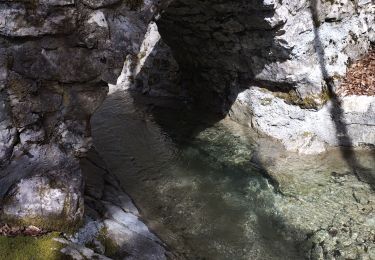
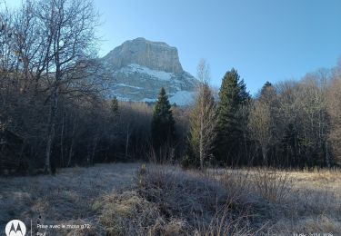
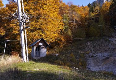
Depuis le parking du Lac de la Puce, la promenade au Lac Noir peut être agréablement prolongée en suivant le Sentier des Charbonniers, un des circuits pédagogiques de découverte proposé par l'ONF. La montée peut se poursuivre jusqu'à la route pas très loin de la cabane forestière sur la D205a. La descente aventureuse du vieux sentier ravira les amateurs d'orientation avant de retrouver le point de départ. Description complète sur sentier-nature.com : Le chemin des charbonniers du Lac Noir Avertissement [Orientation 1/3 ; Pénibilité 2/3]. Pour votre sécurité, nous vous invitons à respecter les règles suivantes : être bien chaussé, ne pas s'engager par mauvais temps, ne pas s'écarter de l'itinéraire ni des sentiers.
Localisation
Commentaires
Randonnées à proximité
![Randonnée Marche Apremont - Mont Joigny, pte de la Georgat, la Lentille, le GD Carroz - Photo](https://media.geolcdn.com/t/375/260/34a799f3-15e1-4e29-b39c-0c906d59ce42.jpg&format=jpg&maxdim=2)
![Marche Marche](https://static1.geolcdn.com/sitytour/trail-icons/101.png)
Marche
![](/images/other/stat-length.png)
![](https://static1.geolcdn.com/siteimages/upload/files/16400158638029165_repeat_loop_refresh_sync_direction_icon.png)
![Randonnée Marche Chapareillan - Le Mont Granier 1933m, depuis Bellecombe - Photo](https://media.geolcdn.com/t/375/260/ext.jpg?maxdim=2&url=https%3A%2F%2Fservices.sitytrail.com%2FGeolivesWS%2FDownloadMedia.ashx%3FTrailID%3D106476%26Media%3D10999_1.jpg)
![Marche Marche](https://static1.geolcdn.com/sitytour/trail-icons/101.png)
Marche
![](/images/other/stat-length.png)
![](https://static1.geolcdn.com/siteimages/upload/files/16400158638029165_repeat_loop_refresh_sync_direction_icon.png)
![Randonnée Marche Entremont-le-Vieux - Le Mont Granier par la cheminée de Tencovaz - Photo](https://media.geolcdn.com/t/375/260/ext.jpg?maxdim=2&url=https%3A%2F%2Fservices.sitytrail.com%2FGeolivesWS%2FDownloadMedia.ashx%3FTrailID%3D103708%26Media%3D6232_1.jpg)
![Marche Marche](https://static1.geolcdn.com/sitytour/trail-icons/101.png)
Marche
![](/images/other/stat-length.png)
![](https://static1.geolcdn.com/siteimages/upload/files/16400158638029165_repeat_loop_refresh_sync_direction_icon.png)
![Randonnée Marche Chapareillan - Le Granier 1933m, par les pas de la Porte et de Bellecombe - Photo](https://media.geolcdn.com/t/375/260/ext.jpg?maxdim=2&url=https%3A%2F%2Fservices.sitytrail.com%2FGeolivesWS%2FDownloadMedia.ashx%3FTrailID%3D102833%26Media%3D3997_1.jpg)
![Marche Marche](https://static1.geolcdn.com/sitytour/trail-icons/101.png)
Marche
![](/images/other/stat-length.png)
![](https://static1.geolcdn.com/siteimages/upload/files/16400158638029165_repeat_loop_refresh_sync_direction_icon.png)
![Randonnée Marche Porte-de-Savoie - lac noir - Photo](https://media.geolcdn.com/t/375/260/499f9890-28e0-48a3-ad89-8f41232ea1db.jpg&format=jpg&maxdim=2)
![Marche Marche](https://static1.geolcdn.com/sitytour/trail-icons/101.png)
Marche
![](/images/other/stat-length.png)
![](https://static1.geolcdn.com/siteimages/upload/files/16400158638029165_repeat_loop_refresh_sync_direction_icon.png)
![Randonnée Marche Entremont-le-Vieux - Le Granier par Tencovaz - Photo](https://media.geolcdn.com/t/375/260/0a6d7d9d-3ccb-410e-b45a-8510ed0c4da6.jpg&format=jpg&maxdim=2)
![Marche Marche](https://static1.geolcdn.com/sitytour/trail-icons/101.png)
Marche
![](/images/other/stat-length.png)
![](https://static1.geolcdn.com/siteimages/upload/files/16400158638029165_repeat_loop_refresh_sync_direction_icon.png)
![Randonnée Marche Barraux - La Cascade du Furet et Bellecombe - Photo](https://media.geolcdn.com/t/375/260/74bbb9d0-501f-468a-b269-49271a27e78b.jpg&format=jpg&maxdim=2)
![Marche Marche](https://static1.geolcdn.com/sitytour/trail-icons/101.png)
Marche
![](/images/other/stat-length.png)
![](https://static1.geolcdn.com/siteimages/upload/files/16400158638029165_repeat_loop_refresh_sync_direction_icon.png)
![Randonnée Marche Entremont-le-Vieux - la Plagne le Pinet :en boucle partielle à partir de la bifurcation GR9 et montée au Pinet - Photo](https://media.geolcdn.com/t/375/260/56a80225-7b96-41d6-aae1-bac3ef64e473.jpg&format=jpg&maxdim=2)
![Marche Marche](https://static1.geolcdn.com/sitytour/trail-icons/101.png)
Marche
![](/images/other/stat-length.png)
![](https://static1.geolcdn.com/siteimages/upload/files/16400158638029165_repeat_loop_refresh_sync_direction_icon.png)
![Randonnée Marche Entremont-le-Vieux - 29 juillet 2023 mont Pinet et rocher de la Fita - Photo](https://media.geolcdn.com/t/375/260/1523d29f-6a1c-4efb-8cab-c63ad2e1b34c.jpg&format=jpg&maxdim=2)
![Marche Marche](https://static1.geolcdn.com/sitytour/trail-icons/101.png)
Marche
![](/images/other/stat-length.png)
![](https://static1.geolcdn.com/siteimages/upload/files/16400158638029165_repeat_loop_refresh_sync_direction_icon.png)