Randonnée V.T.T. La Vespière-Friardel - Randonnée VTT La Vespière 32 Kms 22-05-2011 - Photo

Randonnée VTT La Vespière 32 Kms 22-05-2011

 tracegps
tracegps

Utilisateur

© OpenStreetMap contributors
Longueur
Longueur
33 km
Altitude max
Altitude max
215 m
Dénivelé positif
Dénivelé positif
546 m
Km-Effort
Km-Effort  
40 km
Altitude min
Altitude min
112 m
Dénivelé négatif
Dénivelé négatif
550 m
Boucle
Boucle
Oui
Date de création :
2014-12-10 00:00:00.0
Dernière modification :
2014-12-10 00:00:00.0

(0 Avis)

V.T.T.
V.T.T.
2h00
Difficulté : Moyen

Scannez ce code QR pour ouvrir la randonnée dans l'application SityTrail

Application GPS de randonnée GRATUITE

Logo SityTrail SityTrail

IGN / Instituts géographiques

Télécharger SityTrail sur l'App Store Télécharger SityTrail sur Google Play

Logo SityTrail SityTrail World

Le monde est à vous

Télécharger SityTrail sur l'App Store Télécharger SityTrail sur Google Play Télécharger SityTrail sur Huawei AppGallery

À propos

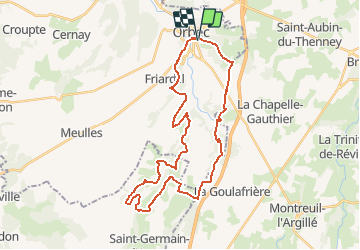
Randonnée V.T.T. de 33 km à découvrir à Normandie, Calvados, La Vespière-Friardel. Cette randonnée est proposée par tracegps.

Description

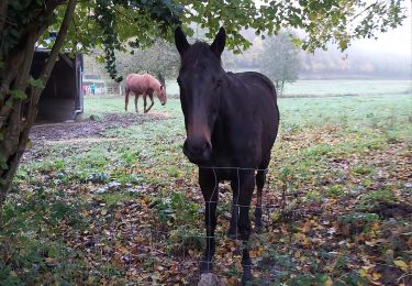
Randonnée VTT de La Vespière du 22 mai 2011 32 Km. Départ parking de la mairie pour une belle randonnée avec beaucoup de Forets, passage par la Foletière Abenon, Saint Aubin de Bonneval et par Friardel. A noter aussi un très beau passage auprès d'un cressonnière. De belles descentes à fond la caisse (attention tout de même) et donc de belle montées avec environ 600 Mètres. Bonne et belle randonnée.

Profil altimétrique

Points d'intérêt

Point d'intérêt La Vespière-Friardel - Randonn?e VTT La Vespiere 32 Kms 22-05-2011 32.653  - Photo
tracegps
LA VESPIÈRE-FRIARDEL 

Localisation

Pays :
France
Région :
Normandie
Département/Province :
Calvados
Commune :
La Vespière-Friardel
Localité :
Unknown
Départ:(Dec)
Départ:(UTM)
310833 ; 5432728 (31U) N.

Randonnées à proximité

Randonnée Vélo Saint-Germain-la-Campagne - Boucle des maisons de maîtres  -  St-Germain la Campagne - Photo
Vélo
tracegps

Vélo

Moyen
(1)
Saint-Germain-la-Campagne, Normandie, Eure, France
16,3 km | 17,4 km-effort
1h 0min
Oui
Randonnée Marche Saint-Martin-de-Bienfaite-la-Cressonnière - saint Martin de bienfaite la cressonnière - Photo
Marche
werth

Marche

Moyen
Saint-Martin-de-Bienfaite-la-Cressonnière, Normandie, Calvados, France
9,6 km | 12,2 km-effort
2h 52min
Oui
Randonnée Marche Livarot-Pays-d'Auge - Cerqueux  - Photo
Marche
Eve - Line

Marche

Facile
Livarot-Pays-d'Auge, Normandie, Calvados, France
8,2 km | 9,1 km-effort
2h 8min
Oui
Randonnée Marche Saint-Germain-la-Campagne - Chemin du Sabot bis - Photo
Marche
FROIDMONT

Marche

Facile
(1)
Saint-Germain-la-Campagne, Normandie, Eure, France
9,8 km | 11,2 km-effort
2h 34min
Oui
Randonnée Marche La Chapelle-Gauthier - La Mare Péreuse - La Chapelle-Gauthier - Photo
Marche
tracegps

Marche

Moyen
La Chapelle-Gauthier, Normandie, Eure, France
10,3 km | 11,9 km-effort
2h 45min
Oui
Randonnée Marche Livarot-Pays-d'Auge - Cerqueux (14) - Photo
Marche
Eve - Line

Marche

Moyen
Livarot-Pays-d'Auge, Normandie, Calvados, France
15,8 km | 18,1 km-effort
3h 43min
Oui
Randonnée Marche Saint-Germain-la-Campagne - st Germain le campagne  - Photo
Marche
ymarvin

Marche

Facile
Saint-Germain-la-Campagne, Normandie, Eure, France
8,3 km | 9,3 km-effort
1h 40min
Oui
Randonnée Marche La Vespière-Friardel - La Vespiere  - Photo
Marche
Eve - Line

Marche

Moyen
La Vespière-Friardel, Normandie, Calvados, France
22 km | 27 km-effort
4h 22min
Oui
Randonnée Marche Saint-Germain-la-Campagne - Chemin du Sabot - St Germain la Campagne - Photo
Marche
tracegps

Marche

Moyen
Saint-Germain-la-Campagne, Normandie, Eure, France
8,6 km | 9,2 km-effort
2h 10min
Oui


Fermer
Mes abonnements