![](/images/other/stat-length.png)
![Randonnée Marche Roissy-en-Brie - Forêt de Ferrières et Ferrières en Brie - Photo](https://media.geolcdn.com/t/1900/400/ext.pjpeg?maxdim=2&url=https%3A%2F%2Fstatic1.geolcdn.com%2Fsiteimages%2Fupload%2Ffiles%2F1553511878bg_sport_marche.png)
Forêt de Ferrières et Ferrières en Brie
Surot
Utilisateur
![Longueur](/images/other/stat-length.png)
Longueur
14,6 km
![Altitude max](https://static1.geolcdn.com/siteimages/upload/files/1508320355ic_sort_altitude_max_24dp.png)
Altitude max
123 m
![Dénivelé positif](https://static1.geolcdn.com/siteimages/upload/files/1508320355ic_sort_den_pos_24dp.png)
Dénivelé positif
97 m
![Km-Effort](/images/other/stat-length.png)
Km-Effort
15,9 km
![Altitude min](https://static1.geolcdn.com/siteimages/upload/files/1508320355ic_sort_altitude_min_24dp.png)
Altitude min
99 m
![Dénivelé négatif](https://static1.geolcdn.com/siteimages/upload/files/1508320355ic_sort_den_neg_24dp.png)
Dénivelé négatif
96 m
![Boucle](https://static1.geolcdn.com/siteimages/upload/files/16400158638029165_repeat_loop_refresh_sync_direction_icon.png)
Boucle
Oui
Date de création :
2019-01-15 18:16:13.144
Dernière modification :
2023-08-24 13:45:26.933
![Marche](https://static1.geolcdn.com/sitytour/trail-icons/101.png)
3h37
Difficulté : Difficile
![Scannez ce code QR pour ouvrir la randonnée dans l'application SityTrail](https://capi.geolives.com/qq0zvz2zws4bq2lad0pu/sitytour/trails/1065291/qr.png?size=200)
Application GPS de randonnée GRATUITE
À propos
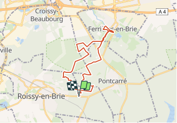
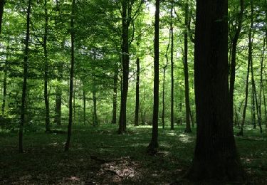
Randonnée Marche de 14,6 km à découvrir à Île-de-France, Seine-et-Marne, Roissy-en-Brie. Cette randonnée est proposée par Surot.
Description
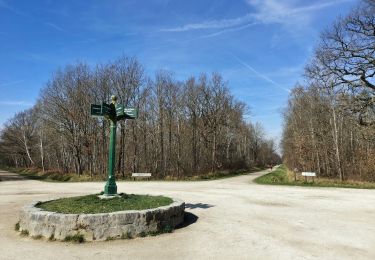
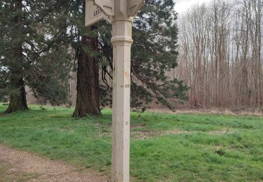
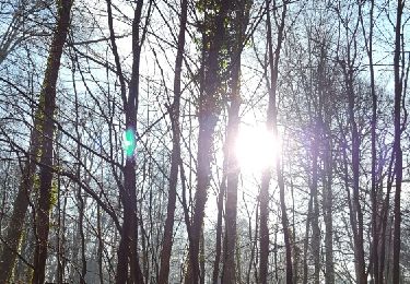
randonnée facile en forêt, sans dénivelé, belle allée des séquoias et joli village de Ferrières en Brie (anciennes buanderie et écuries du chateau, église et café saint Rémy). Sans difficulté, joli site de pique-nique en bord d'étang
Localisation
Pays :
France
Région :
Île-de-France
Département/Province :
Seine-et-Marne
Commune :
Roissy-en-Brie
Localité :
Unknown
Départ:(Dec)
Départ:(UTM)
476585 ; 5404179 (31U) N.
Commentaires
Randonnées à proximité
![Randonnée Marche Émerainville - GRP CV-IDF 13R Emerainville à Marolles-en-Brie - Photo](https://media.geolcdn.com/t/375/260/726621e0-1908-4a49-bd96-d431c02673d0.jpg&format=jpg&maxdim=2)
![Marche Marche](https://static1.geolcdn.com/sitytour/trail-icons/101.png)
GRP CV-IDF 13R Emerainville à Marolles-en-Brie
Marche
Difficile
(1)
Émerainville,
Île-de-France,
Seine-et-Marne,
France
![](/images/other/stat-length.png)
16,8 km | 18,1 km-effort
4h 6min
![](https://static1.geolcdn.com/siteimages/upload/files/16400158638029165_repeat_loop_refresh_sync_direction_icon.png)
Non
![Randonnée Marche Lésigny - J 28 12 km lesigny cimetiere village gr14 - Photo](https://media.geolcdn.com/t/375/260/ext.jpg?maxdim=2&url=https%3A%2F%2Fstatic1.geolcdn.com%2Fsiteimages%2Fupload%2Ffiles%2F1553511878bg_sport_marche.png)
![Marche Marche](https://static1.geolcdn.com/sitytour/trail-icons/101.png)
J 28 12 km lesigny cimetiere village gr14
Marche
Moyen
(4)
Lésigny,
Île-de-France,
Seine-et-Marne,
France
![](/images/other/stat-length.png)
13 km | 14 km-effort
3h 10min
![](https://static1.geolcdn.com/siteimages/upload/files/16400158638029165_repeat_loop_refresh_sync_direction_icon.png)
Oui
![Randonnée A pied Lésigny - L 29 Lésigny Village - Photo](https://media.geolcdn.com/t/375/260/ext.jpg?maxdim=2&url=https%3A%2F%2Fstatic1.geolcdn.com%2Fsiteimages%2Fupload%2Ffiles%2F1545311037marcheuse_200dpi.jpg)
![A pied A pied](https://static1.geolcdn.com/sitytour/trail-icons/100.png)
L 29 Lésigny Village
A pied
Facile
(5)
Lésigny,
Île-de-France,
Seine-et-Marne,
France
![](/images/other/stat-length.png)
5,7 km | 6,1 km-effort
1h 22min
![](https://static1.geolcdn.com/siteimages/upload/files/16400158638029165_repeat_loop_refresh_sync_direction_icon.png)
Oui
![Randonnée A pied Lésigny - L 28 - 5.97km - cimetière Lésigny- villarceau Grande Romaine - Photo](https://media.geolcdn.com/t/375/260/ext.jpg?maxdim=2&url=https%3A%2F%2Fstatic1.geolcdn.com%2Fsiteimages%2Fupload%2Ffiles%2F1545311037marcheuse_200dpi.jpg)
![A pied A pied](https://static1.geolcdn.com/sitytour/trail-icons/100.png)
L 28 - 5.97km - cimetière Lésigny- villarceau Grande Romaine
A pied
Très facile
(4)
Lésigny,
Île-de-France,
Seine-et-Marne,
France
![](/images/other/stat-length.png)
6,5 km | 7,1 km-effort
1h 36min
![](https://static1.geolcdn.com/siteimages/upload/files/16400158638029165_repeat_loop_refresh_sync_direction_icon.png)
Oui
![Randonnée Marche Ferrières-en-Brie - allée des lions Ferrières en brie - Photo](https://media.geolcdn.com/t/375/260/c37505e8-7264-4ccf-bd5a-b749d62d5806.jpg&format=jpg&maxdim=2)
![Marche Marche](https://static1.geolcdn.com/sitytour/trail-icons/101.png)
allée des lions Ferrières en brie
Marche
Facile
Ferrières-en-Brie,
Île-de-France,
Seine-et-Marne,
France
![](/images/other/stat-length.png)
3,3 km | 3,8 km-effort
1h 0min
![](https://static1.geolcdn.com/siteimages/upload/files/16400158638029165_repeat_loop_refresh_sync_direction_icon.png)
Non
![Randonnée Marche Émerainville - GRP CV-IDF 06 - Photo](https://media.geolcdn.com/t/375/260/f3f38049-661d-428f-b85f-806ecbd65903.jpg&format=jpg&maxdim=2)
![Marche Marche](https://static1.geolcdn.com/sitytour/trail-icons/101.png)
GRP CV-IDF 06
Marche
Facile
Émerainville,
Île-de-France,
Seine-et-Marne,
France
![](/images/other/stat-length.png)
14,6 km | 15,8 km-effort
3h 0min
![](https://static1.geolcdn.com/siteimages/upload/files/16400158638029165_repeat_loop_refresh_sync_direction_icon.png)
Non
![Randonnée Marche Ozoir-la-Ferrière - OZOIR > BOISSY 18 KM - Photo](https://media.geolcdn.com/t/375/260/ext.jpg?maxdim=2&url=https%3A%2F%2Fstatic1.geolcdn.com%2Fsiteimages%2Fupload%2Ffiles%2F1553511878bg_sport_marche.png)
![Marche Marche](https://static1.geolcdn.com/sitytour/trail-icons/101.png)
OZOIR > BOISSY 18 KM
Marche
Très facile
(1)
Ozoir-la-Ferrière,
Île-de-France,
Seine-et-Marne,
France
![](/images/other/stat-length.png)
18,7 km | 20 km-effort
4h 14min
![](https://static1.geolcdn.com/siteimages/upload/files/16400158638029165_repeat_loop_refresh_sync_direction_icon.png)
Non
![Randonnée Marche Pontcarré - CRAB : De Férrières à Armainvilliers - Photo](https://media.geolcdn.com/t/375/260/ext.jpg?maxdim=2&url=https%3A%2F%2Fservices.sitytrail.com%2FGeolivesWS%2FDownloadMedia.ashx%3FTrailID%3D687950%26Media%3Dfix__20170122115428.jpg)
![Marche Marche](https://static1.geolcdn.com/sitytour/trail-icons/101.png)
CRAB : De Férrières à Armainvilliers
Marche
Facile
Pontcarré,
Île-de-France,
Seine-et-Marne,
France
![](/images/other/stat-length.png)
21 km | 23 km-effort
4h 5min
![](https://static1.geolcdn.com/siteimages/upload/files/16400158638029165_repeat_loop_refresh_sync_direction_icon.png)
Oui
![Randonnée Marche Favières - ballade - Photo](https://media.geolcdn.com/t/375/260/ext.jpg?maxdim=2&url=https%3A%2F%2Fservices.sitytrail.com%2FGeolivesWS%2FDownloadMedia.ashx%3FTrailID%3D189210%26Media%3D20130505131941.jpg)
![Marche Marche](https://static1.geolcdn.com/sitytour/trail-icons/101.png)
ballade
Marche
Très facile
Favières,
Île-de-France,
Seine-et-Marne,
France
![](/images/other/stat-length.png)
6,7 km | 7,4 km-effort
1h 32min
![](https://static1.geolcdn.com/siteimages/upload/files/16400158638029165_repeat_loop_refresh_sync_direction_icon.png)
Oui