![](/images/other/stat-length.png)
![Randonnée V.T.T. Saint-Denis - De Paris à Meaux via l'Ourq - Photo](https://media.geolcdn.com/t/1900/400/ext.pjpeg?maxdim=2&url=https%3A%2F%2Fservices.sitytrail.com%2FGeolivesWS%2FDownloadMedia.ashx%3FTrailID%3D106512%26Media%3D11065_2.jpg)
De Paris à Meaux via l'Ourq
tracegps
Utilisateur
![Longueur](/images/other/stat-length.png)
![Altitude max](https://static1.geolcdn.com/siteimages/upload/files/1508320355ic_sort_altitude_max_24dp.png)
![Dénivelé positif](https://static1.geolcdn.com/siteimages/upload/files/1508320355ic_sort_den_pos_24dp.png)
![Km-Effort](/images/other/stat-length.png)
![Altitude min](https://static1.geolcdn.com/siteimages/upload/files/1508320355ic_sort_altitude_min_24dp.png)
![Dénivelé négatif](https://static1.geolcdn.com/siteimages/upload/files/1508320355ic_sort_den_neg_24dp.png)
![Boucle](https://static1.geolcdn.com/siteimages/upload/files/16400158638029165_repeat_loop_refresh_sync_direction_icon.png)
![V.T.T.](https://static1.geolcdn.com/sitytour/trail-icons/202.png)
6h00
Difficulté : Moyen
![Scannez ce code QR pour ouvrir la randonnée dans l'application SityTrail](https://capi.geolives.com/qq0zvz2zws4bq2lad0pu/sitytour/trails/106512/qr.png?size=200)
Application GPS de randonnée GRATUITE
À propos
Randonnée V.T.T. de 52 km à découvrir à Île-de-France, Seine-Saint-Denis, Saint-Denis. Cette randonnée est proposée par tracegps.
Description
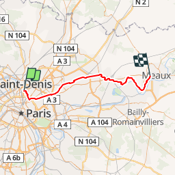
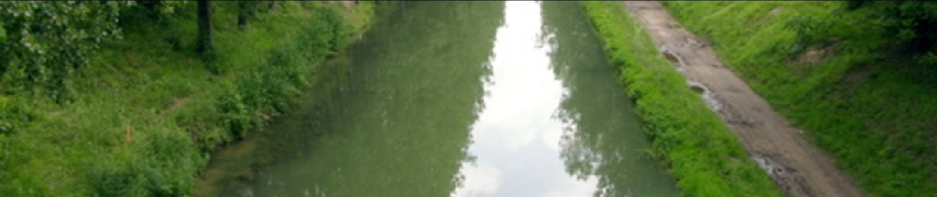
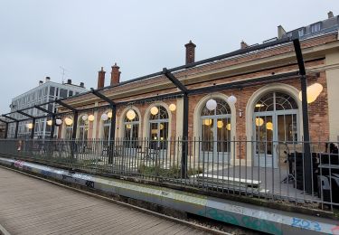
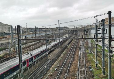
Balade très sympathique le long du canal de l'Ourq. Le circuit est reconstitué de mémoire, il ne devrait pas avoir de soucis modulo la rive à prendre (souvent une rive est plus roulante que l'autre). Départ du RER B Saint-Denis, on rejoint le canal à la Vilette, il n'y a plus qu'a suivre la piste cyclable ou les chemins de halage. On arrive à Meaux et la gare se trouve à coté du canal. On ne peut pas la louper. Le train de Meaux arrive à Gare de l'Est. Suivant l'heure de départ le parc de Sevran peut être sympa pour une pause pic nic.
Localisation
Commentaires
Randonnées à proximité
![Randonnée Marche Paris - Rando à thème : Georges Brassens - Parcours complet - Photo](https://media.geolcdn.com/t/375/260/dd7b2106-cdfc-45d2-b882-21cd74d02774.jpg&format=jpg&maxdim=2)
![Marche Marche](https://static1.geolcdn.com/sitytour/trail-icons/101.png)
Marche
![](/images/other/stat-length.png)
![](https://static1.geolcdn.com/siteimages/upload/files/16400158638029165_repeat_loop_refresh_sync_direction_icon.png)
![Randonnée Marche Paris - 034 - Paris - De place Pereire à République - Photo](https://media.geolcdn.com/t/375/260/6eac2f44-ae7d-4c3a-b4a0-edb2243c2709.jpeg&format=jpg&maxdim=2)
![Marche Marche](https://static1.geolcdn.com/sitytour/trail-icons/101.png)
Marche
![](/images/other/stat-length.png)
![](https://static1.geolcdn.com/siteimages/upload/files/16400158638029165_repeat_loop_refresh_sync_direction_icon.png)
![Randonnée Marche Paris - DP75-04 De Botzaris à Goncourt - Photo](https://media.geolcdn.com/t/375/260/cf17523e-73ae-496a-a6d3-09ca9ab69004.jpg&format=jpg&maxdim=2)
![Marche Marche](https://static1.geolcdn.com/sitytour/trail-icons/101.png)
Marche
![](/images/other/stat-length.png)
![](https://static1.geolcdn.com/siteimages/upload/files/16400158638029165_repeat_loop_refresh_sync_direction_icon.png)
![Randonnée Marche Paris - DP75-03 de Marx Dormoy à Botzaris - Photo](https://media.geolcdn.com/t/375/260/c31fa2f2-52db-4a77-9db8-fab66cf7e1f1.jpg&format=jpg&maxdim=2)
![Marche Marche](https://static1.geolcdn.com/sitytour/trail-icons/101.png)
Marche
![](/images/other/stat-length.png)
![](https://static1.geolcdn.com/siteimages/upload/files/16400158638029165_repeat_loop_refresh_sync_direction_icon.png)
![Randonnée Marche Paris - DP75-01 de Monceau à Guy Môquet - Photo](https://media.geolcdn.com/t/375/260/4fe927af-6700-4051-b3f2-26d2c637f461.jpg&format=jpg&maxdim=2)
![Marche Marche](https://static1.geolcdn.com/sitytour/trail-icons/101.png)
Marche
![](/images/other/stat-length.png)
![](https://static1.geolcdn.com/siteimages/upload/files/16400158638029165_repeat_loop_refresh_sync_direction_icon.png)
![Randonnée Marche Paris - DP75-23 De Pré-Saint-Gervais à Père-Lachaise - Photo](https://media.geolcdn.com/t/375/260/2b34d1c3-14cb-4275-90aa-7639d5865570.jpg&format=jpg&maxdim=2)
![Marche Marche](https://static1.geolcdn.com/sitytour/trail-icons/101.png)
Marche
![](/images/other/stat-length.png)
![](https://static1.geolcdn.com/siteimages/upload/files/16400158638029165_repeat_loop_refresh_sync_direction_icon.png)
![Randonnée Marche Paris - DP75-21 D'Abesse à Riquet - Photo](https://media.geolcdn.com/t/375/260/58cf6e50-2509-470b-9716-51f78c32d42b.jpg&format=jpg&maxdim=2)
![Marche Marche](https://static1.geolcdn.com/sitytour/trail-icons/101.png)
Marche
![](/images/other/stat-length.png)
![](https://static1.geolcdn.com/siteimages/upload/files/16400158638029165_repeat_loop_refresh_sync_direction_icon.png)
![Randonnée Marche Paris - DP75-20 D'Europe à Abbesses - Photo](https://media.geolcdn.com/t/375/260/d682439e-3e3a-41a9-a650-7fa1d5c73231.jpg&format=jpg&maxdim=2)
![Marche Marche](https://static1.geolcdn.com/sitytour/trail-icons/101.png)
Marche
![](/images/other/stat-length.png)
![](https://static1.geolcdn.com/siteimages/upload/files/16400158638029165_repeat_loop_refresh_sync_direction_icon.png)
![Marche Marche](https://static1.geolcdn.com/sitytour/trail-icons/101.png)
Marche
![](/images/other/stat-length.png)
![](https://static1.geolcdn.com/siteimages/upload/files/16400158638029165_repeat_loop_refresh_sync_direction_icon.png)