![](/images/other/stat-length.png)
![Randonnée Marche Laveissière - Le lac Glory de Laveissière - Photo](https://media.geolcdn.com/t/1900/400/ext.pjpeg?maxdim=2&url=https%3A%2F%2Fservices.sitytrail.com%2FGeolivesWS%2FDownloadMedia.ashx%3FTrailID%3D106468%26Media%3D10983_1.jpg)
Le lac Glory de Laveissière
tracegps
Utilisateur
![Longueur](/images/other/stat-length.png)
![Altitude max](https://static1.geolcdn.com/siteimages/upload/files/1508320355ic_sort_altitude_max_24dp.png)
![Dénivelé positif](https://static1.geolcdn.com/siteimages/upload/files/1508320355ic_sort_den_pos_24dp.png)
![Km-Effort](/images/other/stat-length.png)
![Altitude min](https://static1.geolcdn.com/siteimages/upload/files/1508320355ic_sort_altitude_min_24dp.png)
![Dénivelé négatif](https://static1.geolcdn.com/siteimages/upload/files/1508320355ic_sort_den_neg_24dp.png)
![Boucle](https://static1.geolcdn.com/siteimages/upload/files/16400158638029165_repeat_loop_refresh_sync_direction_icon.png)
![Marche](https://static1.geolcdn.com/sitytour/trail-icons/101.png)
4h00
Difficulté : Moyen
![Scannez ce code QR pour ouvrir la randonnée dans l'application SityTrail](https://capi.geolives.com/qq0zvz2zws4bq2lad0pu/sitytour/trails/106468/qr.png?size=200)
Application GPS de randonnée GRATUITE
À propos
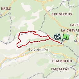
Randonnée Marche de 11,1 km à découvrir à Auvergne-Rhône-Alpes, Cantal, Laveissière. Cette randonnée est proposée par tracegps.
Description
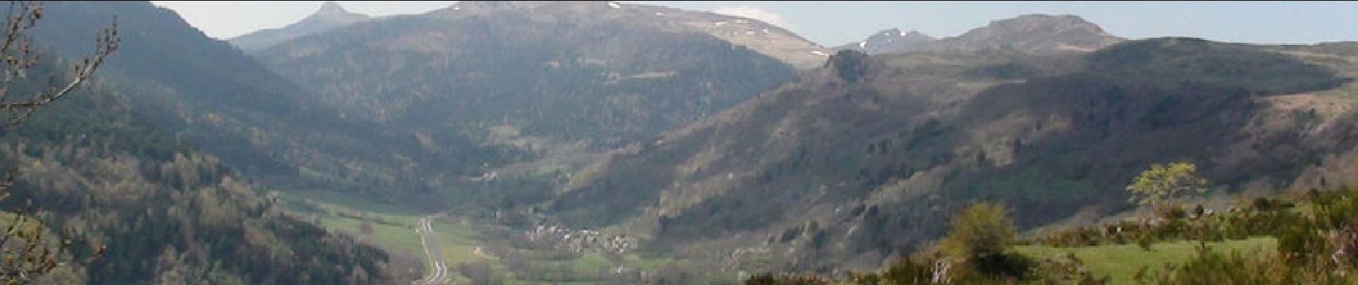
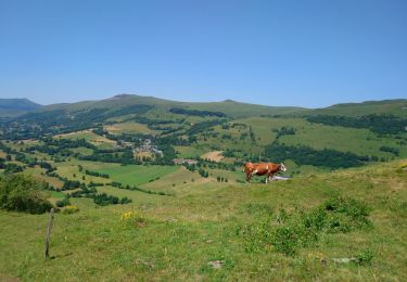
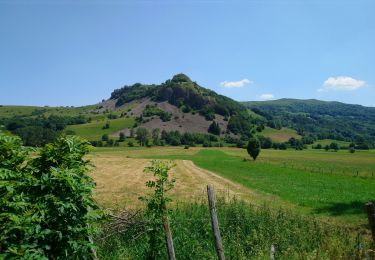
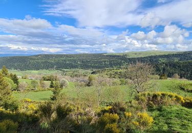
Une balade à faire absolument surtout quand il n'y a pas de vaches dans les montagnes et que la neige a disparu (avant le 15 mai). Les vues sur le Puy Griou, le Peyre Arse, le Rocher de l'Aigle et le Puy de Seycheuse sont magnifiques. Le Chemin d'abord très large, débute non loin du village du Meynial au dessus de Laveissière; il emprunte le chemin de Saint Jacques puis il part à droite pour franchir la barrière rocheuse. Un petit sentier emprunté par les chevreuils et les cervidés très nombreux dans la région guide le randonneur et traverse un pierrier. Sur le plateau on suit, plein Ouest, la barrière rocheuse et par un passage très facile on rejoint un chemin principal. Balade à faire quand il fait beau, sans risque de brouillard ou nuages et avec son GPS.
Localisation
Commentaires
Randonnées à proximité
![Randonnée Marche Dienne - Cantal - le Chaumeil - Dienne et Rocher de Laqueille - 9km 265m 2h50 - 2019 07 05 - Photo](https://media.geolcdn.com/t/375/260/0c8731bc-bb27-41ed-bdb7-c3b60f017a8f.jpg&format=jpg&maxdim=2)
![Marche Marche](https://static1.geolcdn.com/sitytour/trail-icons/101.png)
Marche
![](/images/other/stat-length.png)
![](https://static1.geolcdn.com/siteimages/upload/files/16400158638029165_repeat_loop_refresh_sync_direction_icon.png)
![Randonnée Marche Albepierre-Bredons - Cantal - Albepierre - les Cascades - 9.6km 330m 3h25 - 2019 06 23 - Photo](https://media.geolcdn.com/t/375/260/7c343e5b-9b79-4737-bf33-8f8bb008b3a2.jpg&format=jpg&maxdim=2)
![Marche Marche](https://static1.geolcdn.com/sitytour/trail-icons/101.png)
Marche
![](/images/other/stat-length.png)
![](https://static1.geolcdn.com/siteimages/upload/files/16400158638029165_repeat_loop_refresh_sync_direction_icon.png)
![Randonnée Marche Murat - les estives et tourbière de Chastel sur Murat - Photo](https://media.geolcdn.com/t/375/260/177cc3c3-d770-480f-901b-cbeaabf71678.jpg&format=jpg&maxdim=2)
![Marche Marche](https://static1.geolcdn.com/sitytour/trail-icons/101.png)
Marche
![](/images/other/stat-length.png)
![](https://static1.geolcdn.com/siteimages/upload/files/16400158638029165_repeat_loop_refresh_sync_direction_icon.png)
![Randonnée A pied Dienne - Sentier des Quirous - Photo](https://media.geolcdn.com/t/375/260/b2d36bdd-3820-411f-87f5-46704c0c0a3e.jpeg&format=jpg&maxdim=2)
![A pied A pied](https://static1.geolcdn.com/sitytour/trail-icons/100.png)
A pied
![](/images/other/stat-length.png)
![](https://static1.geolcdn.com/siteimages/upload/files/16400158638029165_repeat_loop_refresh_sync_direction_icon.png)
![Randonnée Marche Dienne - Cantal - Dienne - Drils et Laqueille - 7.2km 205m 2h50 - 2019 07 05 - Photo](https://media.geolcdn.com/t/375/260/02708330-16eb-44ba-9ebc-7103b041fee1.jpg&format=jpg&maxdim=2)
![Marche Marche](https://static1.geolcdn.com/sitytour/trail-icons/101.png)
Marche
![](/images/other/stat-length.png)
![](https://static1.geolcdn.com/siteimages/upload/files/16400158638029165_repeat_loop_refresh_sync_direction_icon.png)
![Randonnée Marche Laveissière - Cantal - Cheyrouze (Laveissière) - Puy de Seycheuse - 14.8km 600m 5h35 - 2019 06 30 - Photo](https://media.geolcdn.com/t/375/260/9aa2826f-ab44-4435-96bc-4a2b060c1cbb.jpg&format=jpg&maxdim=2)
![Marche Marche](https://static1.geolcdn.com/sitytour/trail-icons/101.png)
Marche
![](/images/other/stat-length.png)
![](https://static1.geolcdn.com/siteimages/upload/files/16400158638029165_repeat_loop_refresh_sync_direction_icon.png)
![Randonnée Marche Albepierre-Bredons - Col de la Molède 9,3 km - Albepierre - Photo](https://media.geolcdn.com/t/375/260/4e9bd869-b560-46fe-9b86-9494c4288e90.jpg&format=jpg&maxdim=2)
![Marche Marche](https://static1.geolcdn.com/sitytour/trail-icons/101.png)
Marche
![](/images/other/stat-length.png)
![](https://static1.geolcdn.com/siteimages/upload/files/16400158638029165_repeat_loop_refresh_sync_direction_icon.png)
![Randonnée Marche Dienne - Dienne - Photo](https://media.geolcdn.com/t/375/260/d7747b8a-4487-4ce4-8bd5-a3c88121a183.jpg&format=jpg&maxdim=2)
![Marche Marche](https://static1.geolcdn.com/sitytour/trail-icons/101.png)
Marche
![](/images/other/stat-length.png)
![](https://static1.geolcdn.com/siteimages/upload/files/16400158638029165_repeat_loop_refresh_sync_direction_icon.png)
![Randonnée V.T.C. Albepierre-Bredons - Chambeuil - Photo](https://media.geolcdn.com/t/375/260/d192094d-27ab-4a7b-a974-4a31abcc49f1.jpg&format=jpg&maxdim=2)
![V.T.C. V.T.C.](https://static1.geolcdn.com/sitytour/trail-icons/203.png)
V.T.C.
![](/images/other/stat-length.png)
![](https://static1.geolcdn.com/siteimages/upload/files/16400158638029165_repeat_loop_refresh_sync_direction_icon.png)