![](/images/other/stat-length.png)
![Randonnée V.T.T. Hyères - Site VTT FFC Hyères - les Îles d'Or - La Jean Marc - Photo](https://media.geolcdn.com/t/1900/400/ext.pjpeg?maxdim=2&url=https%3A%2F%2Fservices.sitytrail.com%2FGeolivesWS%2FDownloadMedia.ashx%3FTrailID%3D106437%26Media%3D10941_1.jpg)
Site VTT FFC Hyères - les Îles d'Or - La Jean Marc
tracegps
Utilisateur
![Longueur](/images/other/stat-length.png)
![Altitude max](https://static1.geolcdn.com/siteimages/upload/files/1508320355ic_sort_altitude_max_24dp.png)
![Dénivelé positif](https://static1.geolcdn.com/siteimages/upload/files/1508320355ic_sort_den_pos_24dp.png)
![Km-Effort](/images/other/stat-length.png)
![Altitude min](https://static1.geolcdn.com/siteimages/upload/files/1508320355ic_sort_altitude_min_24dp.png)
![Dénivelé négatif](https://static1.geolcdn.com/siteimages/upload/files/1508320355ic_sort_den_neg_24dp.png)
![Boucle](https://static1.geolcdn.com/siteimages/upload/files/16400158638029165_repeat_loop_refresh_sync_direction_icon.png)
![V.T.T.](https://static1.geolcdn.com/sitytour/trail-icons/202.png)
30m
Difficulté : Difficile
![Scannez ce code QR pour ouvrir la randonnée dans l'application SityTrail](https://capi.geolives.com/qq0zvz2zws4bq2lad0pu/sitytour/trails/106437/qr.png?size=200)
Application GPS de randonnée GRATUITE
À propos
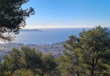
Randonnée V.T.T. de 3 km à découvrir à Provence-Alpes-Côte d'Azur, Var, Hyères. Cette randonnée est proposée par tracegps.
Description
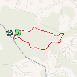
Site VTT FFC Hyères - les Îles d’Or - La Jean Marc. Circuit officiel labellisé par la Fédération Française de Cyclisme. • Couleur de parcours : Rouge (difficile) • Distance : 3,100 km si départ parking stand de tir, si départ vélodrome liaison de 1,6 km. • Dénivelé positif : 144 m • Départ du parking stand de tir ou parking vélodrome Toulon Provence Méditerranée. Descriptif : Circuit pour les pratiquants de l’enduro qui emprunte une ascension accessible sur une piste large mais rendue technique sur la partie finale due aux nombreux cailloux. La descente est technique avec de nombreux sauts fossés, marches en pierres, petites restanques…Pour chaque saut des échappatoires ont été aménagés afin de la rendre accessible à un plus grand nombre de vététistes. Descente technique ou l’on peut prendre beaucoup de vitesse, attention à bien maîtriser sa technique et sa vitesse.
Localisation
Commentaires
Randonnées à proximité
![Randonnée Marche La Crau - Le Paradis et le mont des oiseaux - Photo](https://media.geolcdn.com/t/375/260/3ea9709f-1bf2-4174-850e-73122825f7f5.jpg&format=jpg&maxdim=2)
![Marche Marche](https://static1.geolcdn.com/sitytour/trail-icons/101.png)
Marche
![](/images/other/stat-length.png)
![](https://static1.geolcdn.com/siteimages/upload/files/16400158638029165_repeat_loop_refresh_sync_direction_icon.png)
![Randonnée Marche La Crau - fenouillet Daniel Louis - Photo](https://media.geolcdn.com/t/375/260/74a8e577-0c5f-4f83-9925-bb595eab64a1.jpg&format=jpg&maxdim=2)
![Marche Marche](https://static1.geolcdn.com/sitytour/trail-icons/101.png)
Marche
![](/images/other/stat-length.png)
![](https://static1.geolcdn.com/siteimages/upload/files/16400158638029165_repeat_loop_refresh_sync_direction_icon.png)
![Randonnée Marche La Crau - le fenouillet un après-midi d'automne - Photo](https://media.geolcdn.com/t/375/260/ext.jpg?maxdim=2&url=https%3A%2F%2Fservices.sitytrail.com%2FGeolivesWS%2FDownloadMedia.ashx%3FTrailID%3D650501%26Media%3D20161024161101.jpg)
![Marche Marche](https://static1.geolcdn.com/sitytour/trail-icons/101.png)
Marche
![](/images/other/stat-length.png)
![](https://static1.geolcdn.com/siteimages/upload/files/16400158638029165_repeat_loop_refresh_sync_direction_icon.png)
![Randonnée Trail La Crau - Le Fenouillet et château d' Hyères - Photo](https://media.geolcdn.com/t/375/260/b5c97bc5-16a4-4fca-8ec6-5ff57c47ff40.jpg&format=jpg&maxdim=2)
![Trail Trail](https://static1.geolcdn.com/sitytour/trail-icons/104.png)
Trail
![](/images/other/stat-length.png)
![](https://static1.geolcdn.com/siteimages/upload/files/16400158638029165_repeat_loop_refresh_sync_direction_icon.png)
![Randonnée Marche La Crau - Fenouillet - Chateau de Hyères - retour par les vignes - Photo](https://media.geolcdn.com/t/375/260/d2132167-a625-4ff2-ae44-a142bdaeb4e4.jpg&format=jpg&maxdim=2)
![Marche Marche](https://static1.geolcdn.com/sitytour/trail-icons/101.png)
Marche
![](/images/other/stat-length.png)
![](https://static1.geolcdn.com/siteimages/upload/files/16400158638029165_repeat_loop_refresh_sync_direction_icon.png)
![Randonnée Marche Hyères - La Capte Tour fondue - Photo](https://media.geolcdn.com/t/375/260/5250a63d-1c5b-4d9a-9344-38f4a463abbf.jpg&format=jpg&maxdim=2)
![Marche Marche](https://static1.geolcdn.com/sitytour/trail-icons/101.png)
Marche
![](/images/other/stat-length.png)
![](https://static1.geolcdn.com/siteimages/upload/files/16400158638029165_repeat_loop_refresh_sync_direction_icon.png)
![Randonnée Marche La Crau - fenouillet plan du pont - Photo](https://media.geolcdn.com/t/375/260/b7ab377c-6bf0-4fec-8a5c-2b318085c2ea.jpg&format=jpg&maxdim=2)
![Marche Marche](https://static1.geolcdn.com/sitytour/trail-icons/101.png)
Marche
![](/images/other/stat-length.png)
![](https://static1.geolcdn.com/siteimages/upload/files/16400158638029165_repeat_loop_refresh_sync_direction_icon.png)
![Randonnée Marche Carqueiranne - la grotte du paradis - Photo](https://media.geolcdn.com/t/375/260/9486f261-69b8-4de0-9e87-579eb1d901e8.jpg&format=jpg&maxdim=2)
![Marche Marche](https://static1.geolcdn.com/sitytour/trail-icons/101.png)
Marche
![](/images/other/stat-length.png)
![](https://static1.geolcdn.com/siteimages/upload/files/16400158638029165_repeat_loop_refresh_sync_direction_icon.png)
![Randonnée Marche Hyères - Ayguade plage port - Photo](https://media.geolcdn.com/t/375/260/3ac04e3d-5394-4469-8ff5-f2d403ceda96.jpg&format=jpg&maxdim=2)
![Marche Marche](https://static1.geolcdn.com/sitytour/trail-icons/101.png)
Marche
![](/images/other/stat-length.png)
![](https://static1.geolcdn.com/siteimages/upload/files/16400158638029165_repeat_loop_refresh_sync_direction_icon.png)