![](/images/other/stat-length.png)
![Randonnée V.T.T. Campénéac - Vélo promenade n°6 - Campénéac - Gourhel - Photo](https://media.geolcdn.com/t/1900/400/ext.pjpeg?maxdim=2&url=https%3A%2F%2Fstatic1.geolcdn.com%2Fsiteimages%2Fupload%2Ffiles%2F1524743154velo.jpg)
Vélo promenade n°6 - Campénéac - Gourhel
tracegps
Utilisateur
![Longueur](/images/other/stat-length.png)
![Altitude max](https://static1.geolcdn.com/siteimages/upload/files/1508320355ic_sort_altitude_max_24dp.png)
![Dénivelé positif](https://static1.geolcdn.com/siteimages/upload/files/1508320355ic_sort_den_pos_24dp.png)
![Km-Effort](/images/other/stat-length.png)
![Altitude min](https://static1.geolcdn.com/siteimages/upload/files/1508320355ic_sort_altitude_min_24dp.png)
![Dénivelé négatif](https://static1.geolcdn.com/siteimages/upload/files/1508320355ic_sort_den_neg_24dp.png)
![Boucle](https://static1.geolcdn.com/siteimages/upload/files/16400158638029165_repeat_loop_refresh_sync_direction_icon.png)
![V.T.T.](https://static1.geolcdn.com/sitytour/trail-icons/202.png)
3h30
Difficulté : Difficile
![Scannez ce code QR pour ouvrir la randonnée dans l'application SityTrail](https://capi.geolives.com/qq0zvz2zws4bq2lad0pu/sitytour/trails/106378/qr.png?size=200)
Application GPS de randonnée GRATUITE
À propos
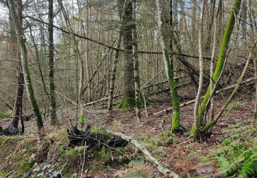
Randonnée V.T.T. de 28 km à découvrir à Bretagne, Morbihan, Campénéac. Cette randonnée est proposée par tracegps.
Description
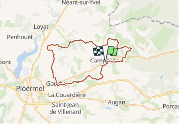
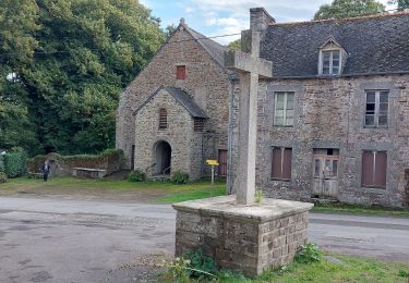
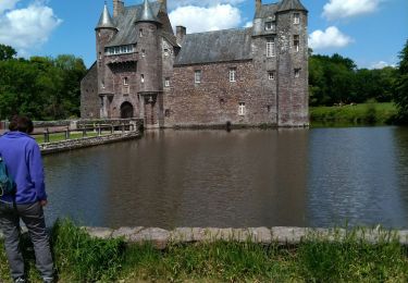
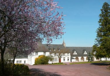
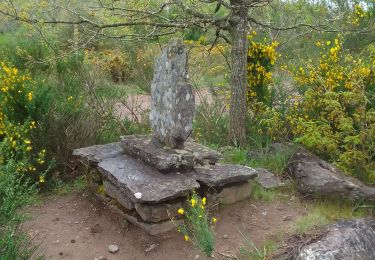
Point de départ : Bourg de Campénéac (coordonnées GPS : 02°17’36’’O / 47°57’25’’N) - Distance : 30km (3h30) – niveau soutenu - Modifier le numéro et sa couleur sur la flèche. Partie « À voir en chemin » 1. Le château de Trécesson : propriété privée construite au 15ème siècle. Le plus beau château de Brocéliande est bien sûr entouré de légendes : on raconte qu’il garde le souvenir tragique de cette mariée enterrée vivante au pied de ses murailles… 2. L’abbaye la Joie Notre Dame : seule abbaye de cisterciennes en Bretagne, elle accueille les visiteurs et propose des biscuits, chocolats et autres douceurs fabriqués par les sœurs. 3. Le Pas aux Biches : c’est sans doute l’un des châtaigniers les plus impressionnants du Morbihan. Sauvé grâce à son achat par la commune, le châtaignier de Campénéac mesure près de 20 mètres de hauteur, 9.10 mètres de circonférence et est âgé de plus de 400 ans ! 4. L’étang de Campéanéac : avant de revenir au point de départ vous pourrez vous délassez un instant au bord de l’étang. Contact Office de tourisme de Ploërmel « Terres de légendes » - Tel: 02 97 74 02 70 – accueil (at) tourisme-ploermel.com
Localisation
Commentaires
Randonnées à proximité
![Randonnée Marche Campénéac - Château de TRECESSON - Tombeau du Géant - L'Hotié de la Fée Viviane - (8/2019) - Photo](https://media.geolcdn.com/t/375/260/6dc55585-1341-4962-8006-32206bea207b.jpg&format=jpg&maxdim=2)
![Marche Marche](https://static1.geolcdn.com/sitytour/trail-icons/101.png)
Marche
![](/images/other/stat-length.png)
![](https://static1.geolcdn.com/siteimages/upload/files/16400158638029165_repeat_loop_refresh_sync_direction_icon.png)
![Randonnée Marche Paimpont - GR_37_CE_39_Paimpont_Mauron_20220924 - Photo](https://media.geolcdn.com/t/375/260/d0e9fad4-0af6-4e10-b643-661a6c1313a8.jpg&format=jpg&maxdim=2)
![Marche Marche](https://static1.geolcdn.com/sitytour/trail-icons/101.png)
Marche
![](/images/other/stat-length.png)
![](https://static1.geolcdn.com/siteimages/upload/files/16400158638029165_repeat_loop_refresh_sync_direction_icon.png)
![Randonnée A pied Campénéac - Les Landes de Gurwan - Photo](https://media.geolcdn.com/t/375/260/b737382d-2b17-4f2d-90a4-5777864a81d4.jpeg&format=jpg&maxdim=2)
![A pied A pied](https://static1.geolcdn.com/sitytour/trail-icons/100.png)
A pied
![](/images/other/stat-length.png)
![](https://static1.geolcdn.com/siteimages/upload/files/16400158638029165_repeat_loop_refresh_sync_direction_icon.png)
![Randonnée Marche Campénéac - l'arbre d'or Val sans retour - Photo](https://media.geolcdn.com/t/375/260/1799521b-97a1-40bd-ba1e-99ab40d78482.jpg&format=jpg&maxdim=2)
![Marche Marche](https://static1.geolcdn.com/sitytour/trail-icons/101.png)
Marche
![](/images/other/stat-length.png)
![](https://static1.geolcdn.com/siteimages/upload/files/16400158638029165_repeat_loop_refresh_sync_direction_icon.png)
![Randonnée Marche Campénéac - Circuit des Landes Rennaises - Campénéac - Photo](https://media.geolcdn.com/t/375/260/ext.jpg?maxdim=2&url=https%3A%2F%2Fservices.sitytrail.com%2FGeolivesWS%2FDownloadMedia.ashx%3FTrailID%3D111741%26Media%3D8143_5.jpg)
![Marche Marche](https://static1.geolcdn.com/sitytour/trail-icons/101.png)
Marche
![](/images/other/stat-length.png)
![](https://static1.geolcdn.com/siteimages/upload/files/16400158638029165_repeat_loop_refresh_sync_direction_icon.png)
![Randonnée Marche Paimpont - Paimpont 1 - Photo](https://media.geolcdn.com/t/375/260/83bfaa3b-4047-4ce0-8e02-90ebcbcc185a.jpg&format=jpg&maxdim=2)
![Marche Marche](https://static1.geolcdn.com/sitytour/trail-icons/101.png)
Marche
![](/images/other/stat-length.png)
![](https://static1.geolcdn.com/siteimages/upload/files/16400158638029165_repeat_loop_refresh_sync_direction_icon.png)
![Randonnée Marche Campénéac - campe2 - Photo](https://media.geolcdn.com/t/375/260/7199eabc-bee6-4cb5-bea0-8b880964cd40.jpg&format=jpg&maxdim=2)
![Marche Marche](https://static1.geolcdn.com/sitytour/trail-icons/101.png)
![Randonnée Course à pied Campénéac - joie nd arbre d or val sans retour - Photo](https://media.geolcdn.com/t/375/260/c11e82d2-d80a-45d2-9e0c-433f6b59cdf3.jpg&format=jpg&maxdim=2)
![Course à pied Course à pied](https://static1.geolcdn.com/sitytour/trail-icons/103.png)
Course à pied
![](/images/other/stat-length.png)
![](https://static1.geolcdn.com/siteimages/upload/files/16400158638029165_repeat_loop_refresh_sync_direction_icon.png)
![Randonnée Marche Campénéac - campe - Photo](https://media.geolcdn.com/t/375/260/805b4dfd-5102-48a1-8e35-9b2469201689.jpg&format=jpg&maxdim=2)
![Marche Marche](https://static1.geolcdn.com/sitytour/trail-icons/101.png)