![](/images/other/stat-length.png)
![Randonnée V.T.T. Champagne-sur-Oise - La Champenoise 2011 - Photo](https://media.geolcdn.com/t/1900/400/ext.pjpeg?maxdim=2&url=https%3A%2F%2Fstatic1.geolcdn.com%2Fsiteimages%2Fupload%2Ffiles%2F1524743154velo.jpg)
La Champenoise 2011
tracegps
Utilisateur
![Longueur](/images/other/stat-length.png)
Longueur
67 km
![Altitude max](https://static1.geolcdn.com/siteimages/upload/files/1508320355ic_sort_altitude_max_24dp.png)
Altitude max
176 m
![Dénivelé positif](https://static1.geolcdn.com/siteimages/upload/files/1508320355ic_sort_den_pos_24dp.png)
Dénivelé positif
1180 m
![Km-Effort](/images/other/stat-length.png)
Km-Effort
82 km
![Altitude min](https://static1.geolcdn.com/siteimages/upload/files/1508320355ic_sort_altitude_min_24dp.png)
Altitude min
27 m
![Dénivelé négatif](https://static1.geolcdn.com/siteimages/upload/files/1508320355ic_sort_den_neg_24dp.png)
Dénivelé négatif
1177 m
![Boucle](https://static1.geolcdn.com/siteimages/upload/files/16400158638029165_repeat_loop_refresh_sync_direction_icon.png)
Boucle
Oui
Date de création :
2014-12-10 00:00:00.0
Dernière modification :
2014-12-10 00:00:00.0
![V.T.T.](https://static1.geolcdn.com/sitytour/trail-icons/202.png)
4h00
Difficulté : Difficile
![Scannez ce code QR pour ouvrir la randonnée dans l'application SityTrail](https://capi.geolives.com/qq0zvz2zws4bq2lad0pu/sitytour/trails/106340/qr.png?size=200)
Application GPS de randonnée GRATUITE
À propos
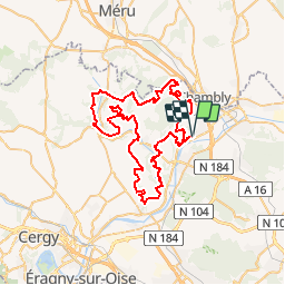
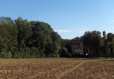
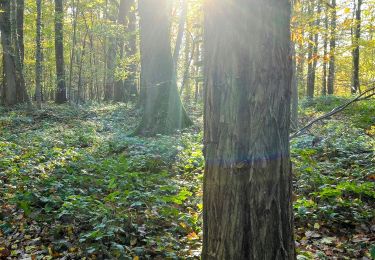
Randonnée V.T.T. de 67 km à découvrir à Île-de-France, Val-d'Oise, Champagne-sur-Oise. Cette randonnée est proposée par tracegps.
Description
Tracé de la Champenoise 2011 avec une modification au niveau de Messelan car le chemin n'est pas permanent. Le parcours a sa part de ludique et de physique, et les quelques traversées de champs se font oublier.
Localisation
Pays :
France
Région :
Île-de-France
Département/Province :
Val-d'Oise
Commune :
Champagne-sur-Oise
Localité :
Unknown
Départ:(Dec)
Départ:(UTM)
443904 ; 5442623 (31U) N.
Commentaires
Randonnées à proximité
![Randonnée Marche Parmain - L Parmain jean Sarment a Valmondoit - Photo](https://media.geolcdn.com/t/375/260/f077cbce-67ad-4318-aa64-96311b6a86ee.jpg&format=jpg&maxdim=2)
![Marche Marche](https://static1.geolcdn.com/sitytour/trail-icons/101.png)
L Parmain jean Sarment a Valmondoit
Marche
Très facile
(1)
Parmain,
Île-de-France,
Val-d'Oise,
France
![](/images/other/stat-length.png)
7,9 km | 9,5 km-effort
2h 10min
![](https://static1.geolcdn.com/siteimages/upload/files/16400158638029165_repeat_loop_refresh_sync_direction_icon.png)
Oui
![Randonnée Marche Presles - autour de Presles - Photo](https://media.geolcdn.com/t/375/260/ext.jpg?maxdim=2&url=https%3A%2F%2Fservices.sitytrail.com%2FGeolivesWS%2FDownloadMedia.ashx%3FTrailID%3D263831%26Media%3D20140406161403.jpg)
![Marche Marche](https://static1.geolcdn.com/sitytour/trail-icons/101.png)
autour de Presles
Marche
Facile
(2)
Presles,
Île-de-France,
Val-d'Oise,
France
![](/images/other/stat-length.png)
9 km | 10,4 km-effort
1h 48min
![](https://static1.geolcdn.com/siteimages/upload/files/16400158638029165_repeat_loop_refresh_sync_direction_icon.png)
Oui
![Randonnée Marche L'Isle-Adam - Autour de l'Isle Adam - Photo](https://media.geolcdn.com/t/375/260/ext.jpg?maxdim=2&url=https%3A%2F%2Fservices.sitytrail.com%2FGeolivesWS%2FDownloadMedia.ashx%3FTrailID%3D110076%26Media%3D5235_1.jpg)
![Marche Marche](https://static1.geolcdn.com/sitytour/trail-icons/101.png)
Autour de l'Isle Adam
Marche
Difficile
(1)
L'Isle-Adam,
Île-de-France,
Val-d'Oise,
France
![](/images/other/stat-length.png)
22 km | 26 km-effort
4h 30min
![](https://static1.geolcdn.com/siteimages/upload/files/16400158638029165_repeat_loop_refresh_sync_direction_icon.png)
Oui
![Randonnée Marche Valmondois - Vallée de Nesles - Photo](https://media.geolcdn.com/t/375/260/ext.jpg?maxdim=2&url=https%3A%2F%2Fservices.sitytrail.com%2FGeolivesWS%2FDownloadMedia.ashx%3FTrailID%3D110075%26Media%3D5234_1.jpg)
![Marche Marche](https://static1.geolcdn.com/sitytour/trail-icons/101.png)
Vallée de Nesles
Marche
Difficile
(1)
Valmondois,
Île-de-France,
Val-d'Oise,
France
![](/images/other/stat-length.png)
23 km | 28 km-effort
4h 45min
![](https://static1.geolcdn.com/siteimages/upload/files/16400158638029165_repeat_loop_refresh_sync_direction_icon.png)
Oui
![Randonnée Marche Parmain - Vexin - Villages et vallée du Saucerron De Parmain à - Photo](https://media.geolcdn.com/t/375/260/aca25e33-a79c-4f90-a1b6-75a268e3ab26.jpg&format=jpg&maxdim=2)
![Marche Marche](https://static1.geolcdn.com/sitytour/trail-icons/101.png)
Vexin - Villages et vallée du Saucerron De Parmain à
Marche
Moyen
Parmain,
Île-de-France,
Val-d'Oise,
France
![](/images/other/stat-length.png)
27 km | 33 km-effort
5h 51min
![](https://static1.geolcdn.com/siteimages/upload/files/16400158638029165_repeat_loop_refresh_sync_direction_icon.png)
Non
![Randonnée Marche L'Isle-Adam - Le tour du Grand Paris via le GR1 - ETAPE 6 de L'isle Adam à Viarmes - Photo](https://media.geolcdn.com/t/375/260/36124db9-71e6-43bc-985e-e2ee8f4439b2.jpg&format=jpg&maxdim=2)
![Marche Marche](https://static1.geolcdn.com/sitytour/trail-icons/101.png)
Le tour du Grand Paris via le GR1 - ETAPE 6 de L'isle Adam à Viarmes
Marche
Moyen
L'Isle-Adam,
Île-de-France,
Val-d'Oise,
France
![](/images/other/stat-length.png)
28 km | 36 km-effort
5h 1min
![](https://static1.geolcdn.com/siteimages/upload/files/16400158638029165_repeat_loop_refresh_sync_direction_icon.png)
Non
![Randonnée A pied L'Isle-Adam - L'Isle-Adam 02 L'Isle Adam - Photo](https://media.geolcdn.com/t/375/260/ext.jpg?maxdim=2&url=https%3A%2F%2Fstatic1.geolcdn.com%2Fsiteimages%2Fupload%2Ffiles%2F1545311037marcheuse_200dpi.jpg)
![A pied A pied](https://static1.geolcdn.com/sitytour/trail-icons/100.png)
L'Isle-Adam 02 L'Isle Adam
A pied
Très facile
(1)
L'Isle-Adam,
Île-de-France,
Val-d'Oise,
France
![](/images/other/stat-length.png)
9,4 km | 10,7 km-effort
3h 0min
![](https://static1.geolcdn.com/siteimages/upload/files/16400158638029165_repeat_loop_refresh_sync_direction_icon.png)
Oui
![Randonnée Marche Beaumont-sur-Oise - Rando Beaumont-Carnelle - Photo](https://media.geolcdn.com/t/375/260/ext.jpg?maxdim=2&url=https%3A%2F%2Fstatic1.geolcdn.com%2Fsiteimages%2Fupload%2Ffiles%2F1553511878bg_sport_marche.png)
![Marche Marche](https://static1.geolcdn.com/sitytour/trail-icons/101.png)
Rando Beaumont-Carnelle
Marche
Moyen
(2)
Beaumont-sur-Oise,
Île-de-France,
Val-d'Oise,
France
![](/images/other/stat-length.png)
12,9 km | 16,4 km-effort
3h 31min
![](https://static1.geolcdn.com/siteimages/upload/files/16400158638029165_repeat_loop_refresh_sync_direction_icon.png)
Oui
![Randonnée Marche Champagne-sur-Oise - Autour de Parmain - Photo](https://media.geolcdn.com/t/375/260/ext.jpg?maxdim=2&url=https%3A%2F%2Fstatic1.geolcdn.com%2Fsiteimages%2Fupload%2Ffiles%2F1553511878bg_sport_marche.png)
![Marche Marche](https://static1.geolcdn.com/sitytour/trail-icons/101.png)
Autour de Parmain
Marche
Moyen
(1)
Champagne-sur-Oise,
Île-de-France,
Val-d'Oise,
France
![](/images/other/stat-length.png)
18,9 km | 23 km-effort
4h 0min
![](https://static1.geolcdn.com/siteimages/upload/files/16400158638029165_repeat_loop_refresh_sync_direction_icon.png)
Non