![](/images/other/stat-length.png)
![Randonnée V.T.T. Grande-Synthe - Grand' Synthoise VTT 2011 - Photo](https://media.geolcdn.com/t/1900/400/ext.pjpeg?maxdim=2&url=https%3A%2F%2Fstatic1.geolcdn.com%2Fsiteimages%2Fupload%2Ffiles%2F1524743154velo.jpg)
Grand' Synthoise VTT 2011
tracegps
Utilisateur
![Longueur](/images/other/stat-length.png)
Longueur
21 km
![Altitude max](https://static1.geolcdn.com/siteimages/upload/files/1508320355ic_sort_altitude_max_24dp.png)
Altitude max
11 m
![Dénivelé positif](https://static1.geolcdn.com/siteimages/upload/files/1508320355ic_sort_den_pos_24dp.png)
Dénivelé positif
131 m
![Km-Effort](/images/other/stat-length.png)
Km-Effort
23 km
![Altitude min](https://static1.geolcdn.com/siteimages/upload/files/1508320355ic_sort_altitude_min_24dp.png)
Altitude min
-3 m
![Dénivelé négatif](https://static1.geolcdn.com/siteimages/upload/files/1508320355ic_sort_den_neg_24dp.png)
Dénivelé négatif
131 m
![Boucle](https://static1.geolcdn.com/siteimages/upload/files/16400158638029165_repeat_loop_refresh_sync_direction_icon.png)
Boucle
Oui
Date de création :
2014-12-10 00:00:00.0
Dernière modification :
2014-12-10 00:00:00.0
![V.T.T.](https://static1.geolcdn.com/sitytour/trail-icons/202.png)
1h30
Difficulté : Moyen
![Scannez ce code QR pour ouvrir la randonnée dans l'application SityTrail](https://capi.geolives.com/qq0zvz2zws4bq2lad0pu/sitytour/trails/106302/qr.png?size=200)
Application GPS de randonnée GRATUITE
À propos
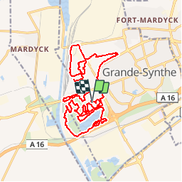
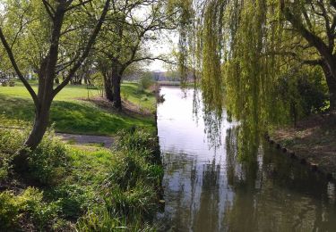
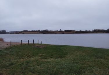
Randonnée V.T.T. de 21 km à découvrir à Hauts-de-France, Nord, Grande-Synthe. Cette randonnée est proposée par tracegps.
Description
L'occasion de découvrir la ville autrement puisque l'OGS VTT, qui s'occupe du balisage du parcours, s'efforce de trouver des chemins de traverse pour relier les nombreux espaces verts dans et autour de la ville.
Localisation
Pays :
France
Région :
Hauts-de-France
Département/Province :
Nord
Commune :
Grande-Synthe
Localité :
Unknown
Départ:(Dec)
Départ:(UTM)
449492 ; 5650511 (31U) N.
Commentaires
Randonnées à proximité
![Randonnée Marche Grande-Synthe - grande synthe - Photo](https://media.geolcdn.com/t/375/260/3e789b0e-70eb-428b-922c-58ed6006b5b7.jpg&format=jpg&maxdim=2)
![Marche Marche](https://static1.geolcdn.com/sitytour/trail-icons/101.png)
grande synthe
Marche
Très facile
Grande-Synthe,
Hauts-de-France,
Nord,
France
![](/images/other/stat-length.png)
9,1 km | 9,8 km-effort
1h 36min
![](https://static1.geolcdn.com/siteimages/upload/files/16400158638029165_repeat_loop_refresh_sync_direction_icon.png)
Non
![Randonnée Marche Grande-Synthe - Circuit du Noord-Gracht - Grande-Synthe - Photo](https://media.geolcdn.com/t/375/260/ext.jpg?maxdim=2&url=https%3A%2F%2Fservices.sitytrail.com%2FGeolivesWS%2FDownloadMedia.ashx%3FTrailID%3D110274%26Media%3D5657_6.jpg)
![Marche Marche](https://static1.geolcdn.com/sitytour/trail-icons/101.png)
Circuit du Noord-Gracht - Grande-Synthe
Marche
Facile
Grande-Synthe,
Hauts-de-France,
Nord,
France
![](/images/other/stat-length.png)
5,6 km | 6 km-effort
1h 30min
![](https://static1.geolcdn.com/siteimages/upload/files/16400158638029165_repeat_loop_refresh_sync_direction_icon.png)
Oui
![Randonnée Marche Grande-Synthe - Circuit du Puythouck - Grande-Synthe - Photo](https://media.geolcdn.com/t/375/260/ext.jpg?maxdim=2&url=https%3A%2F%2Fservices.sitytrail.com%2FGeolivesWS%2FDownloadMedia.ashx%3FTrailID%3D110273%26Media%3D5656_6.jpg)
![Marche Marche](https://static1.geolcdn.com/sitytour/trail-icons/101.png)
Circuit du Puythouck - Grande-Synthe
Marche
Facile
Grande-Synthe,
Hauts-de-France,
Nord,
France
![](/images/other/stat-length.png)
4,4 km | 4,8 km-effort
1h 10min
![](https://static1.geolcdn.com/siteimages/upload/files/16400158638029165_repeat_loop_refresh_sync_direction_icon.png)
Oui
![Randonnée Marche Grande-Synthe - grande synthe grandeur nature - Photo](https://media.geolcdn.com/t/375/260/00085ba4-14d6-4232-a022-a05397b30f11.jpg&format=jpg&maxdim=2)
![Marche Marche](https://static1.geolcdn.com/sitytour/trail-icons/101.png)
grande synthe grandeur nature
Marche
Facile
Grande-Synthe,
Hauts-de-France,
Nord,
France
![](/images/other/stat-length.png)
9,7 km | 10,4 km-effort
1h 52min
![](https://static1.geolcdn.com/siteimages/upload/files/16400158638029165_repeat_loop_refresh_sync_direction_icon.png)
Oui
![Randonnée Marche Grande-Synthe - bouffé d'R au puytoucj - Photo](https://media.geolcdn.com/t/375/260/b09cfb1c-c026-475b-a408-5286d9fee2f3.jpg&format=jpg&maxdim=2)
![Marche Marche](https://static1.geolcdn.com/sitytour/trail-icons/101.png)
bouffé d'R au puytoucj
Marche
Très facile
Grande-Synthe,
Hauts-de-France,
Nord,
France
![](/images/other/stat-length.png)
2,7 km | 2,9 km-effort
28min
![](https://static1.geolcdn.com/siteimages/upload/files/16400158638029165_repeat_loop_refresh_sync_direction_icon.png)
Oui
![Randonnée Marche Loon-Plage - Visite de Loon-Plage - Photo](https://media.geolcdn.com/t/375/260/ext.jpg?maxdim=2&url=https%3A%2F%2Fstatic1.geolcdn.com%2Fsiteimages%2Fupload%2Ffiles%2F1553511878bg_sport_marche.png)
![Marche Marche](https://static1.geolcdn.com/sitytour/trail-icons/101.png)
Visite de Loon-Plage
Marche
Moyen
Loon-Plage,
Hauts-de-France,
Nord,
France
![](/images/other/stat-length.png)
7,4 km | 7,6 km-effort
1h 35min
![](https://static1.geolcdn.com/siteimages/upload/files/16400158638029165_repeat_loop_refresh_sync_direction_icon.png)
Oui
![Randonnée A pied Loon-Plage - Autour de Loon-Plage - Photo](https://media.geolcdn.com/t/375/260/ext.jpg?maxdim=2&url=https%3A%2F%2Fstatic1.geolcdn.com%2Fsiteimages%2Fupload%2Ffiles%2F1545311037marcheuse_200dpi.jpg)
![A pied A pied](https://static1.geolcdn.com/sitytour/trail-icons/100.png)
Autour de Loon-Plage
A pied
Très difficile
Loon-Plage,
Hauts-de-France,
Nord,
France
![](/images/other/stat-length.png)
90 km | 94 km-effort
19h 50min
![](https://static1.geolcdn.com/siteimages/upload/files/16400158638029165_repeat_loop_refresh_sync_direction_icon.png)
Oui
![Randonnée Marche Grande-Synthe - Visite de Grande-Synthe - Photo](https://media.geolcdn.com/t/375/260/ext.jpg?maxdim=2&url=https%3A%2F%2Fstatic1.geolcdn.com%2Fsiteimages%2Fupload%2Ffiles%2F1553511878bg_sport_marche.png)
![Marche Marche](https://static1.geolcdn.com/sitytour/trail-icons/101.png)
Visite de Grande-Synthe
Marche
Très difficile
Grande-Synthe,
Hauts-de-France,
Nord,
France
![](/images/other/stat-length.png)
25 km | 26 km-effort
5h 32min
![](https://static1.geolcdn.com/siteimages/upload/files/16400158638029165_repeat_loop_refresh_sync_direction_icon.png)
Oui
![Randonnée A pied Grande-Synthe - Autour de Grande-Synthe - Photo](https://media.geolcdn.com/t/375/260/ext.jpg?maxdim=2&url=https%3A%2F%2Fstatic1.geolcdn.com%2Fsiteimages%2Fupload%2Ffiles%2F1545311037marcheuse_200dpi.jpg)
![A pied A pied](https://static1.geolcdn.com/sitytour/trail-icons/100.png)
Autour de Grande-Synthe
A pied
Difficile
Grande-Synthe,
Hauts-de-France,
Nord,
France
![](/images/other/stat-length.png)
30 km | 32 km-effort
6h 26min
![](https://static1.geolcdn.com/siteimages/upload/files/16400158638029165_repeat_loop_refresh_sync_direction_icon.png)
Oui