![](/images/other/stat-length.png)
![Randonnée Raquettes à neige Lescun - Pas d'Azuns - Lescun - Photo](https://media.geolcdn.com/t/1900/400/ext.pjpeg?maxdim=2&url=https%3A%2F%2Fservices.sitytrail.com%2FGeolivesWS%2FDownloadMedia.ashx%3FTrailID%3D106264%26Media%3D10616_6.jpg)
Pas d'Azuns - Lescun
tracegps
Utilisateur
![Longueur](/images/other/stat-length.png)
![Altitude max](https://static1.geolcdn.com/siteimages/upload/files/1508320355ic_sort_altitude_max_24dp.png)
![Dénivelé positif](https://static1.geolcdn.com/siteimages/upload/files/1508320355ic_sort_den_pos_24dp.png)
![Km-Effort](/images/other/stat-length.png)
![Altitude min](https://static1.geolcdn.com/siteimages/upload/files/1508320355ic_sort_altitude_min_24dp.png)
![Dénivelé négatif](https://static1.geolcdn.com/siteimages/upload/files/1508320355ic_sort_den_neg_24dp.png)
![Boucle](https://static1.geolcdn.com/siteimages/upload/files/16400158638029165_repeat_loop_refresh_sync_direction_icon.png)
![Raquettes à neige](https://static1.geolcdn.com/sitytour/trail-icons/504.png)
3h00
Difficulté : Difficile
![Scannez ce code QR pour ouvrir la randonnée dans l'application SityTrail](https://capi.geolives.com/qq0zvz2zws4bq2lad0pu/sitytour/trails/106264/qr.png?size=200)
Application GPS de randonnée GRATUITE
À propos
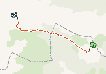
Randonnée Raquettes à neige de 4,5 km à découvrir à Nouvelle-Aquitaine, Pyrénées-Atlantiques, Lescun. Cette randonnée est proposée par tracegps.
Description
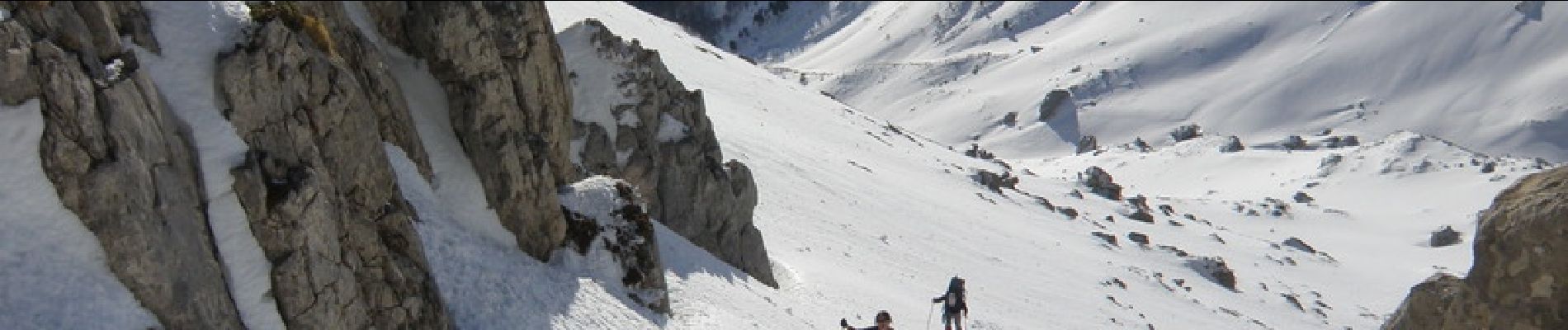
Petite randonnée très agréable, au départ du refuge de Labérouat, qui offre des vues magnifiques sur le Billare, le Pic du Midi d'Ossau, le Pic de Countendé, et le majestueux Pic d'Anie qui est à portée de main. Ce parcours a été effectué en conditions hivernales et en raquettes. En été, on empruntera plutôt le sentier qui passe à proximité de cette trace GPS. Il convient, avant d'entreprendre cette randonnée, d'évaluer les conditions neigeuses qui peuvent rendre le parcours dangereux (neige verglacée, risques d'avalanches, ...)
Localisation
Commentaires
Randonnées à proximité
![Randonnée Marche Lescun - Le plateau de Sanchèse - Lescun - Photo](https://media.geolcdn.com/t/375/260/ext.jpg?maxdim=2&url=https%3A%2F%2Fservices.sitytrail.com%2FGeolivesWS%2FDownloadMedia.ashx%3FTrailID%3D111284%26Media%3D6928_1.jpg)
![Marche Marche](https://static1.geolcdn.com/sitytour/trail-icons/101.png)
Marche
![](/images/other/stat-length.png)
![](https://static1.geolcdn.com/siteimages/upload/files/16400158638029165_repeat_loop_refresh_sync_direction_icon.png)
![Randonnée Marche Lescun - Lac de Lhurs - Photo](https://media.geolcdn.com/t/375/260/ext.jpg?maxdim=2&url=https%3A%2F%2Fservices.sitytrail.com%2FGeolivesWS%2FDownloadMedia.ashx%3FTrailID%3D106243%26Media%3D10574_1.jpg)
![Marche Marche](https://static1.geolcdn.com/sitytour/trail-icons/101.png)
Marche
![](/images/other/stat-length.png)
![](https://static1.geolcdn.com/siteimages/upload/files/16400158638029165_repeat_loop_refresh_sync_direction_icon.png)
![Randonnée A pied Osse-en-Aspe - Tour panoramique Osse-Athas asp109 - Photo](https://media.geolcdn.com/t/375/260/fd742eea-9420-4aa3-9b7d-11c6f4a57c86.jpeg&format=jpg&maxdim=2)
![A pied A pied](https://static1.geolcdn.com/sitytour/trail-icons/100.png)
A pied
![](/images/other/stat-length.png)
![](https://static1.geolcdn.com/siteimages/upload/files/16400158638029165_repeat_loop_refresh_sync_direction_icon.png)
![Randonnée A pied Lescun - Cabanes et Lac de Lhurs asp51 - Photo](https://media.geolcdn.com/t/375/260/6a266a45-7e80-4faa-8425-ef35e57a7e4a.jpeg&format=jpg&maxdim=2)
![A pied A pied](https://static1.geolcdn.com/sitytour/trail-icons/100.png)
A pied
![](/images/other/stat-length.png)
![](https://static1.geolcdn.com/siteimages/upload/files/16400158638029165_repeat_loop_refresh_sync_direction_icon.png)
![Randonnée A pied Lées-Athas - Chemin d'Esquit à Lescun asp46 - Photo](https://media.geolcdn.com/t/375/260/f2e56414-5888-41b7-b503-d53feec7e149.jpeg&format=jpg&maxdim=2)
![A pied A pied](https://static1.geolcdn.com/sitytour/trail-icons/100.png)
A pied
![](/images/other/stat-length.png)
![](https://static1.geolcdn.com/siteimages/upload/files/16400158638029165_repeat_loop_refresh_sync_direction_icon.png)
![Randonnée A pied Lescun - Tour du Belvédère asp47 - Photo](https://media.geolcdn.com/t/375/260/3d73b6d7-975c-44ff-8d63-4ea540b69f0c.jpeg&format=jpg&maxdim=2)
![A pied A pied](https://static1.geolcdn.com/sitytour/trail-icons/100.png)
A pied
![](/images/other/stat-length.png)
![](https://static1.geolcdn.com/siteimages/upload/files/16400158638029165_repeat_loop_refresh_sync_direction_icon.png)
![Randonnée A pied Lées-Athas - Tour du Vallon asp11 - Photo](https://media.geolcdn.com/t/375/260/2a9d4696-f777-4a16-902f-6373154f4697.jpeg&format=jpg&maxdim=2)
![A pied A pied](https://static1.geolcdn.com/sitytour/trail-icons/100.png)
A pied
![](/images/other/stat-length.png)
![](https://static1.geolcdn.com/siteimages/upload/files/16400158638029165_repeat_loop_refresh_sync_direction_icon.png)
![Randonnée A pied Lescun - Refuge de Linza par le Col de Pétragème asp119 - Photo](https://media.geolcdn.com/t/375/260/96f1c4ac-fbcc-4ef8-930f-02b32609dc3b.jpeg&format=jpg&maxdim=2)
![A pied A pied](https://static1.geolcdn.com/sitytour/trail-icons/100.png)
A pied
![](/images/other/stat-length.png)
![](https://static1.geolcdn.com/siteimages/upload/files/16400158638029165_repeat_loop_refresh_sync_direction_icon.png)
![Randonnée Marche Lescun - Cirque de Lescun - Photo](https://media.geolcdn.com/t/375/260/d435ee66-b9e1-4e5f-a628-c21e49952bda.jpg&format=jpg&maxdim=2)
![Marche Marche](https://static1.geolcdn.com/sitytour/trail-icons/101.png)
Marche
![](/images/other/stat-length.png)
![](https://static1.geolcdn.com/siteimages/upload/files/16400158638029165_repeat_loop_refresh_sync_direction_icon.png)