![](/images/other/stat-length.png)
![Randonnée V.T.T. Agneaux - Le tour de Saint Lô en VTT - Photo](https://media.geolcdn.com/t/1900/400/ext.pjpeg?maxdim=2&url=https%3A%2F%2Fstatic1.geolcdn.com%2Fsiteimages%2Fupload%2Ffiles%2F1524743154velo.jpg)
Le tour de Saint Lô en VTT
tracegps
Utilisateur
![Longueur](/images/other/stat-length.png)
Longueur
44 km
![Altitude max](https://static1.geolcdn.com/siteimages/upload/files/1508320355ic_sort_altitude_max_24dp.png)
Altitude max
138 m
![Dénivelé positif](https://static1.geolcdn.com/siteimages/upload/files/1508320355ic_sort_den_pos_24dp.png)
Dénivelé positif
758 m
![Km-Effort](/images/other/stat-length.png)
Km-Effort
54 km
![Altitude min](https://static1.geolcdn.com/siteimages/upload/files/1508320355ic_sort_altitude_min_24dp.png)
Altitude min
3 m
![Dénivelé négatif](https://static1.geolcdn.com/siteimages/upload/files/1508320355ic_sort_den_neg_24dp.png)
Dénivelé négatif
765 m
![Boucle](https://static1.geolcdn.com/siteimages/upload/files/16400158638029165_repeat_loop_refresh_sync_direction_icon.png)
Boucle
Oui
Date de création :
2014-12-10 00:00:00.0
Dernière modification :
2014-12-10 00:00:00.0
![V.T.T.](https://static1.geolcdn.com/sitytour/trail-icons/202.png)
3h00
Difficulté : Difficile
![Scannez ce code QR pour ouvrir la randonnée dans l'application SityTrail](https://capi.geolives.com/qq0zvz2zws4bq2lad0pu/sitytour/trails/106222/qr.png?size=200)
Application GPS de randonnée GRATUITE
À propos
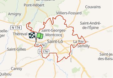
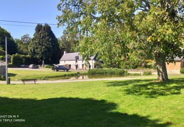
Randonnée V.T.T. de 44 km à découvrir à Normandie, Manche, Agneaux. Cette randonnée est proposée par tracegps.
Description
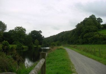
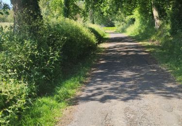
Circuit qui fait le tour de Saint-Lo, agréable, beaucoup de chemin, aucun portage mais quelques bonnes montées surtout par leur longueur.
Localisation
Pays :
France
Région :
Normandie
Département/Province :
Manche
Commune :
Agneaux
Localité :
Unknown
Départ:(Dec)
Départ:(UTM)
636260 ; 5441738 (30U) N.
Commentaires
Randonnées à proximité
![Randonnée V.T.T. Saint-Gilles - Balade St-Gillaise - St-Gilles - Photo](https://media.geolcdn.com/t/375/260/ext.jpg?maxdim=2&url=https%3A%2F%2Fservices.sitytrail.com%2FGeolivesWS%2FDownloadMedia.ashx%3FTrailID%3D172838%26Media%3D14279_6.jpg)
![V.T.T. V.T.T.](https://static1.geolcdn.com/sitytour/trail-icons/202.png)
Balade St-Gillaise - St-Gilles
V.T.T.
Moyen
(1)
Saint-Gilles,
Normandie,
Manche,
France
![](/images/other/stat-length.png)
23 km | 28 km-effort
2h 30min
![](https://static1.geolcdn.com/siteimages/upload/files/16400158638029165_repeat_loop_refresh_sync_direction_icon.png)
Oui
![Randonnée Marche Saint-Gilles - St Gilles Château de Canisy - Photo](https://media.geolcdn.com/t/375/260/db5febae-3142-43c2-8a06-1e780b067eee.jpg&format=jpg&maxdim=2)
![Marche Marche](https://static1.geolcdn.com/sitytour/trail-icons/101.png)
St Gilles Château de Canisy
Marche
Très facile
Saint-Gilles,
Normandie,
Manche,
France
![](/images/other/stat-length.png)
9 km | 10,7 km-effort
2h 26min
![](https://static1.geolcdn.com/siteimages/upload/files/16400158638029165_repeat_loop_refresh_sync_direction_icon.png)
Oui
![Randonnée V.T.T. Agneaux - L'Agnelaise 2014 - Agneaux - Photo](https://media.geolcdn.com/t/375/260/ext.jpg?maxdim=2&url=https%3A%2F%2Fservices.sitytrail.com%2FGeolivesWS%2FDownloadMedia.ashx%3FTrailID%3D317800%26Media%3D17129_4.jpg)
![V.T.T. V.T.T.](https://static1.geolcdn.com/sitytour/trail-icons/202.png)
L'Agnelaise 2014 - Agneaux
V.T.T.
Difficile
Agneaux,
Normandie,
Manche,
France
![](/images/other/stat-length.png)
44 km | 52 km-effort
3h 0min
![](https://static1.geolcdn.com/siteimages/upload/files/16400158638029165_repeat_loop_refresh_sync_direction_icon.png)
Oui
![Randonnée Marche Canisy - Le circuit Jean Follain - Canisy - Photo](https://media.geolcdn.com/t/375/260/ext.jpg?maxdim=2&url=https%3A%2F%2Fservices.sitytrail.com%2FGeolivesWS%2FDownloadMedia.ashx%3FTrailID%3D129872%26Media%3D13437_5.jpg)
![Marche Marche](https://static1.geolcdn.com/sitytour/trail-icons/101.png)
Le circuit Jean Follain - Canisy
Marche
Moyen
Canisy,
Normandie,
Manche,
France
![](/images/other/stat-length.png)
9,2 km | 10,9 km-effort
2h 19min
![](https://static1.geolcdn.com/siteimages/upload/files/16400158638029165_repeat_loop_refresh_sync_direction_icon.png)
Oui
![Randonnée Marche Saint-Lô - Saint-Lô - La Vire et le Falaise - Photo](https://media.geolcdn.com/t/375/260/a4b62c59-4242-4d9f-b094-dbf8b73d474c.jpg&format=jpg&maxdim=2)
![Marche Marche](https://static1.geolcdn.com/sitytour/trail-icons/101.png)
Saint-Lô - La Vire et le Falaise
Marche
Facile
Saint-Lô,
Normandie,
Manche,
France
![](/images/other/stat-length.png)
5,4 km | 6,6 km-effort
1h 20min
![](https://static1.geolcdn.com/siteimages/upload/files/16400158638029165_repeat_loop_refresh_sync_direction_icon.png)
Oui
![Randonnée Marche Saint-Lô - BALLADE 2 JUIN - Photo](https://media.geolcdn.com/t/375/260/26c1ed40-ed31-4507-bef7-09f3441ee504.jpg&format=jpg&maxdim=2)
![Marche Marche](https://static1.geolcdn.com/sitytour/trail-icons/101.png)
BALLADE 2 JUIN
Marche
Très facile
Saint-Lô,
Normandie,
Manche,
France
![](/images/other/stat-length.png)
3,1 km | 3,7 km-effort
51min
![](https://static1.geolcdn.com/siteimages/upload/files/16400158638029165_repeat_loop_refresh_sync_direction_icon.png)
Oui
![Randonnée Marche Saint-Lô - Ballade 2 juin 2020 - Photo](https://media.geolcdn.com/t/375/260/0f66b39a-8cca-4e3f-ad8a-3abe33dff7b7.jpg&format=jpg&maxdim=2)
![Marche Marche](https://static1.geolcdn.com/sitytour/trail-icons/101.png)
Ballade 2 juin 2020
Marche
Très facile
Saint-Lô,
Normandie,
Manche,
France
![](/images/other/stat-length.png)
3,6 km | 4,2 km-effort
1h 2min
![](https://static1.geolcdn.com/siteimages/upload/files/16400158638029165_repeat_loop_refresh_sync_direction_icon.png)
Oui
![Randonnée Marche Saint-Lô - Ballade - Photo](https://media.geolcdn.com/t/375/260/0bb29947-3bff-4454-861d-57fdbde00341.jpg&format=jpg&maxdim=2)
![Marche Marche](https://static1.geolcdn.com/sitytour/trail-icons/101.png)
![Randonnée Marche Saint-Lô - Le Hutrel 27 ai 2020 - Photo](https://media.geolcdn.com/t/375/260/e03ee600-a6e3-4abf-99c3-6fe0b8bda48f.jpg&format=jpg&maxdim=2)
![Marche Marche](https://static1.geolcdn.com/sitytour/trail-icons/101.png)
Le Hutrel 27 ai 2020
Marche
Très facile
Saint-Lô,
Normandie,
Manche,
France
![](/images/other/stat-length.png)
2,3 km | 2,9 km-effort
48min
![](https://static1.geolcdn.com/siteimages/upload/files/16400158638029165_repeat_loop_refresh_sync_direction_icon.png)
Oui