![](/images/other/stat-length.png)
![Randonnée Course à pied Guitté - La Ker al Lann - Edition 2011 - Photo](https://media.geolcdn.com/t/1900/400/ext.pjpeg?maxdim=2&url=https%3A%2F%2Fservices.sitytrail.com%2FGeolivesWS%2FDownloadMedia.ashx%3FTrailID%3D106216%26Media%3D10503_1.jpg)
La Ker al Lann - Edition 2011
tracegps
Utilisateur
![Longueur](/images/other/stat-length.png)
Longueur
18,9 km
![Altitude max](https://static1.geolcdn.com/siteimages/upload/files/1508320355ic_sort_altitude_max_24dp.png)
Altitude max
121 m
![Dénivelé positif](https://static1.geolcdn.com/siteimages/upload/files/1508320355ic_sort_den_pos_24dp.png)
Dénivelé positif
328 m
![Km-Effort](/images/other/stat-length.png)
Km-Effort
23 km
![Altitude min](https://static1.geolcdn.com/siteimages/upload/files/1508320355ic_sort_altitude_min_24dp.png)
Altitude min
46 m
![Dénivelé négatif](https://static1.geolcdn.com/siteimages/upload/files/1508320355ic_sort_den_neg_24dp.png)
Dénivelé négatif
329 m
![Boucle](https://static1.geolcdn.com/siteimages/upload/files/16400158638029165_repeat_loop_refresh_sync_direction_icon.png)
Boucle
Oui
Date de création :
2014-12-10 00:00:00.0
Dernière modification :
2014-12-10 00:00:00.0
![Course à pied](https://static1.geolcdn.com/sitytour/trail-icons/103.png)
2h00
Difficulté : Difficile
![Scannez ce code QR pour ouvrir la randonnée dans l'application SityTrail](https://capi.geolives.com/qq0zvz2zws4bq2lad0pu/sitytour/trails/106216/qr.png?size=200)
Application GPS de randonnée GRATUITE
À propos
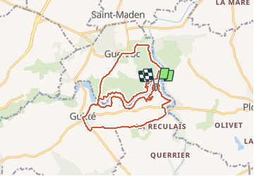
Randonnée Course à pied de 18,9 km à découvrir à Bretagne, Côtes-d'Armor, Guitté. Cette randonnée est proposée par tracegps.
Description
Circuit boucle en repassant sur le pont de Beaumont : Correspondant au Trail/Rando "la ker al lann" qui se déroulera le 17 Avril 2011 par l'association "les amis du don". Renseignement au 06.80.33.73.32
Localisation
Pays :
France
Région :
Bretagne
Département/Province :
Côtes-d'Armor
Commune :
Guitté
Localité :
Unknown
Départ:(Dec)
Départ:(UTM)
569760 ; 5350693 (30U) N.
Commentaires
Randonnées à proximité
![Randonnée Marche Médréac - GR_37_CA_35_Medreac_Montauban-Bretagne_20220717 - Photo](https://media.geolcdn.com/t/375/260/a833a548-224d-4716-b686-e6a524888d35.jpg&format=jpg&maxdim=2)
![Marche Marche](https://static1.geolcdn.com/sitytour/trail-icons/101.png)
GR_37_CA_35_Medreac_Montauban-Bretagne_20220717
Marche
Très facile
Médréac,
Bretagne,
Ille-et-Vilaine,
France
![](/images/other/stat-length.png)
18,2 km | 21 km-effort
4h 35min
![](https://static1.geolcdn.com/siteimages/upload/files/16400158638029165_repeat_loop_refresh_sync_direction_icon.png)
Non
![Randonnée A pied Médréac - Médréac - vallée du Néal - Photo](https://media.geolcdn.com/t/375/260/6fcf6f27-79a1-443f-acf5-becfca97849e.jpeg&format=jpg&maxdim=2)
![A pied A pied](https://static1.geolcdn.com/sitytour/trail-icons/100.png)
Médréac - vallée du Néal
A pied
Moyen
Médréac,
Bretagne,
Ille-et-Vilaine,
France
![](/images/other/stat-length.png)
18,1 km | 22 km-effort
4h 56min
![](https://static1.geolcdn.com/siteimages/upload/files/16400158638029165_repeat_loop_refresh_sync_direction_icon.png)
Oui
![Randonnée Marche Guenroc - Circuit de Guenroc - Photo](https://media.geolcdn.com/t/375/260/ext.jpg?maxdim=2&url=https%3A%2F%2Fservices.sitytrail.com%2FGeolivesWS%2FDownloadMedia.ashx%3FTrailID%3D112059%26Media%3D9606_3.jpg)
![Marche Marche](https://static1.geolcdn.com/sitytour/trail-icons/101.png)
Circuit de Guenroc
Marche
Moyen
Guenroc,
Bretagne,
Côtes-d'Armor,
France
![](/images/other/stat-length.png)
7,6 km | 9 km-effort
2h 0min
![](https://static1.geolcdn.com/siteimages/upload/files/16400158638029165_repeat_loop_refresh_sync_direction_icon.png)
Oui
![Randonnée Marche Guitté - Circuit de la vallée de la Rance et des menhirs - Guitté - Photo](https://media.geolcdn.com/t/375/260/ext.jpg?maxdim=2&url=https%3A%2F%2Fservices.sitytrail.com%2FGeolivesWS%2FDownloadMedia.ashx%3FTrailID%3D111766%26Media%3D8251_1.jpg)
![Marche Marche](https://static1.geolcdn.com/sitytour/trail-icons/101.png)
Circuit de la vallée de la Rance et des menhirs - Guitté
Marche
Facile
Guitté,
Bretagne,
Côtes-d'Armor,
France
![](/images/other/stat-length.png)
3,7 km | 4,7 km-effort
1h 0min
![](https://static1.geolcdn.com/siteimages/upload/files/16400158638029165_repeat_loop_refresh_sync_direction_icon.png)
Oui
![Randonnée Marche Guitté - La Ker al Lann - Edition 2011 - Photo](https://media.geolcdn.com/t/375/260/ext.jpg?maxdim=2&url=https%3A%2F%2Fservices.sitytrail.com%2FGeolivesWS%2FDownloadMedia.ashx%3FTrailID%3D106215%26Media%3D10503_1.jpg)
![Marche Marche](https://static1.geolcdn.com/sitytour/trail-icons/101.png)
La Ker al Lann - Edition 2011
Marche
Moyen
Guitté,
Bretagne,
Côtes-d'Armor,
France
![](/images/other/stat-length.png)
18,9 km | 23 km-effort
4h 30min
![](https://static1.geolcdn.com/siteimages/upload/files/16400158638029165_repeat_loop_refresh_sync_direction_icon.png)
Oui
![Randonnée Marche Guenroc - 22-15-Barrage de Rophémel - Photo](https://media.geolcdn.com/t/375/260/ext.jpg?maxdim=2&url=https%3A%2F%2Fstatic1.geolcdn.com%2Fsiteimages%2Fupload%2Ffiles%2F1553511878bg_sport_marche.png)
![Marche Marche](https://static1.geolcdn.com/sitytour/trail-icons/101.png)
22-15-Barrage de Rophémel
Marche
Très difficile
Guenroc,
Bretagne,
Côtes-d'Armor,
France
![](/images/other/stat-length.png)
16,6 km | 21 km-effort
6h 39min
![](https://static1.geolcdn.com/siteimages/upload/files/16400158638029165_repeat_loop_refresh_sync_direction_icon.png)
Oui
![Randonnée Marche Saint-Juvat - La hautiere st-Juvat - Photo](https://media.geolcdn.com/t/375/260/a7a672e9-4486-4e95-9ca7-ab22aec0d20e.jpg&format=jpg&maxdim=2)
![Marche Marche](https://static1.geolcdn.com/sitytour/trail-icons/101.png)
La hautiere st-Juvat
Marche
Moyen
Saint-Juvat,
Bretagne,
Côtes-d'Armor,
France
![](/images/other/stat-length.png)
6,6 km | 7,5 km-effort
1h 38min
![](https://static1.geolcdn.com/siteimages/upload/files/16400158638029165_repeat_loop_refresh_sync_direction_icon.png)
Oui
![Randonnée Marche Médréac - medreac - Photo](https://media.geolcdn.com/t/375/260/ext.jpg?maxdim=2&url=https%3A%2F%2Fstatic1.geolcdn.com%2Fsiteimages%2Fupload%2Ffiles%2F1553511878bg_sport_marche.png)
![Marche Marche](https://static1.geolcdn.com/sitytour/trail-icons/101.png)
medreac
Marche
Difficile
Médréac,
Bretagne,
Ille-et-Vilaine,
France
![](/images/other/stat-length.png)
13,8 km | 16,5 km-effort
3h 40min
![](https://static1.geolcdn.com/siteimages/upload/files/16400158638029165_repeat_loop_refresh_sync_direction_icon.png)
Non
![Randonnée V.T.C. Guitté - Gwenroch - Photo](https://media.geolcdn.com/t/375/260/ext.jpg?maxdim=2&url=https%3A%2F%2Fstatic1.geolcdn.com%2Fsiteimages%2Fupload%2Ffiles%2F1524743154velo.jpg)
![V.T.C. V.T.C.](https://static1.geolcdn.com/sitytour/trail-icons/203.png)