![](/images/other/stat-length.png)
![Randonnée Marche Vaugrigneuse - Machery - Limours - Photo](https://media.geolcdn.com/t/1900/400/ext.pjpeg?maxdim=2&url=https%3A%2F%2Fstatic1.geolcdn.com%2Fsiteimages%2Fupload%2Ffiles%2F1553511878bg_sport_marche.png)
Machery - Limours
tracegps
Utilisateur
![Longueur](/images/other/stat-length.png)
Longueur
21 km
![Altitude max](https://static1.geolcdn.com/siteimages/upload/files/1508320355ic_sort_altitude_max_24dp.png)
Altitude max
177 m
![Dénivelé positif](https://static1.geolcdn.com/siteimages/upload/files/1508320355ic_sort_den_pos_24dp.png)
Dénivelé positif
276 m
![Km-Effort](/images/other/stat-length.png)
Km-Effort
25 km
![Altitude min](https://static1.geolcdn.com/siteimages/upload/files/1508320355ic_sort_altitude_min_24dp.png)
Altitude min
81 m
![Dénivelé négatif](https://static1.geolcdn.com/siteimages/upload/files/1508320355ic_sort_den_neg_24dp.png)
Dénivelé négatif
276 m
![Boucle](https://static1.geolcdn.com/siteimages/upload/files/16400158638029165_repeat_loop_refresh_sync_direction_icon.png)
Boucle
Oui
Date de création :
2014-12-10 00:00:00.0
Dernière modification :
2014-12-10 00:00:00.0
![Marche](https://static1.geolcdn.com/sitytour/trail-icons/101.png)
5h00
Difficulté : Moyen
![Scannez ce code QR pour ouvrir la randonnée dans l'application SityTrail](https://capi.geolives.com/qq0zvz2zws4bq2lad0pu/sitytour/trails/106135/qr.png?size=200)
Application GPS de randonnée GRATUITE
À propos
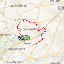
Randonnée Marche de 21 km à découvrir à Île-de-France, Essonne, Vaugrigneuse. Cette randonnée est proposée par tracegps.
Description
21 kms sans dénivelé significatif. Traversée urbaine de Limours non gênante car pas très longue... Il s'agit d'une rando allégée et inspirée de la rando VTT de 30 kms "Autour de Limours" . J'en profite pour remercier son auteur.
Localisation
Pays :
France
Région :
Île-de-France
Département/Province :
Essonne
Commune :
Vaugrigneuse
Localité :
Unknown
Départ:(Dec)
Départ:(UTM)
432522 ; 5383729 (31U) N.
Commentaires
Randonnées à proximité
![Randonnée Marche Bonnelles - _Le rallye de Bonnelles à Rochefort - Photo](https://media.geolcdn.com/t/375/260/ext.jpg?maxdim=2&url=https%3A%2F%2Fservices.sitytrail.com%2FGeolivesWS%2FDownloadMedia.ashx%3FTrailID%3D172070%26Media%3De98fa123-dbbb-4948-ab08-19666b29bb58.jpg)
![Marche Marche](https://static1.geolcdn.com/sitytour/trail-icons/101.png)
_Le rallye de Bonnelles à Rochefort
Marche
Moyen
(10)
Bonnelles,
Île-de-France,
Yvelines,
France
![](/images/other/stat-length.png)
14,1 km | 16,4 km-effort
3h 30min
![](https://static1.geolcdn.com/siteimages/upload/files/16400158638029165_repeat_loop_refresh_sync_direction_icon.png)
Oui
![Randonnée Marche Limours - Essonne_RD_Limours=>Viaduc=>Prédecelle=>Chaumusson - Photo](https://media.geolcdn.com/t/375/260/c60124a9-cca7-4dae-90e5-561e58250ffa.jpg&format=jpg&maxdim=2)
![Marche Marche](https://static1.geolcdn.com/sitytour/trail-icons/101.png)
Essonne_RD_Limours=>Viaduc=>Prédecelle=>Chaumusson
Marche
Facile
(1)
Limours,
Île-de-France,
Essonne,
France
![](/images/other/stat-length.png)
7,4 km | 8,4 km-effort
2h 30min
![](https://static1.geolcdn.com/siteimages/upload/files/16400158638029165_repeat_loop_refresh_sync_direction_icon.png)
Oui
![Randonnée Marche Limours - 20210319_Limours_Viaduc_Prédecelle_Amont - Photo](https://media.geolcdn.com/t/375/260/c60124a9-cca7-4dae-90e5-561e58250ffa.jpg&format=jpg&maxdim=2)
![Marche Marche](https://static1.geolcdn.com/sitytour/trail-icons/101.png)
20210319_Limours_Viaduc_Prédecelle_Amont
Marche
Facile
(1)
Limours,
Île-de-France,
Essonne,
France
![](/images/other/stat-length.png)
8,7 km | 9,9 km-effort
2h 30min
![](https://static1.geolcdn.com/siteimages/upload/files/16400158638029165_repeat_loop_refresh_sync_direction_icon.png)
Oui
![Randonnée Marche Pecqueuse - 20191019_Tour_des_Fermes_réalisé - Photo](https://media.geolcdn.com/t/375/260/3b6cb32e-1ca9-460c-8665-52898ea68512.jpg&format=jpg&maxdim=2)
![Marche Marche](https://static1.geolcdn.com/sitytour/trail-icons/101.png)
20191019_Tour_des_Fermes_réalisé
Marche
Très facile
(1)
Pecqueuse,
Île-de-France,
Essonne,
France
![](/images/other/stat-length.png)
13,8 km | 15,2 km-effort
3h 43min
![](https://static1.geolcdn.com/siteimages/upload/files/16400158638029165_repeat_loop_refresh_sync_direction_icon.png)
Oui
![Randonnée Marche Courson-Monteloup - Boucle au départ du château de Courson - Photo](https://media.geolcdn.com/t/375/260/ed11977b-20c0-4900-b0e3-aa6abed829d7.jpg&format=jpg&maxdim=2)
![Marche Marche](https://static1.geolcdn.com/sitytour/trail-icons/101.png)
Boucle au départ du château de Courson
Marche
Facile
Courson-Monteloup,
Île-de-France,
Essonne,
France
![](/images/other/stat-length.png)
23 km | 27 km-effort
5h 7min
![](https://static1.geolcdn.com/siteimages/upload/files/16400158638029165_repeat_loop_refresh_sync_direction_icon.png)
Oui
![Randonnée Marche Saint-Maurice-Montcouronne - Boucle St Maurice Montcouronne - Brigitte - Photo](https://media.geolcdn.com/t/375/260/0e3ebb94-9c16-4bc9-9efb-ddbb902c3347.jpg&format=jpg&maxdim=2)
![Marche Marche](https://static1.geolcdn.com/sitytour/trail-icons/101.png)
Boucle St Maurice Montcouronne - Brigitte
Marche
Très facile
Saint-Maurice-Montcouronne,
Île-de-France,
Essonne,
France
![](/images/other/stat-length.png)
21 km | 24 km-effort
4h 19min
![](https://static1.geolcdn.com/siteimages/upload/files/16400158638029165_repeat_loop_refresh_sync_direction_icon.png)
Oui
![Randonnée V.T.T. Limours - St Arnoult 33km-2h30 - Photo](https://media.geolcdn.com/t/375/260/ext.jpg?maxdim=2&url=https%3A%2F%2Fstatic1.geolcdn.com%2Fsiteimages%2Fupload%2Ffiles%2F1524743154velo.jpg)
![V.T.T. V.T.T.](https://static1.geolcdn.com/sitytour/trail-icons/202.png)
St Arnoult 33km-2h30
V.T.T.
Difficile
(1)
Limours,
Île-de-France,
Essonne,
France
![](/images/other/stat-length.png)
34 km | 39 km-effort
2h 33min
![](https://static1.geolcdn.com/siteimages/upload/files/16400158638029165_repeat_loop_refresh_sync_direction_icon.png)
Oui
![Randonnée V.T.T. Bonnelles - Bonnelle - Photo](https://media.geolcdn.com/t/375/260/ext.jpg?maxdim=2&url=https%3A%2F%2Fstatic1.geolcdn.com%2Fsiteimages%2Fupload%2Ffiles%2F1524743154velo.jpg)
![V.T.T. V.T.T.](https://static1.geolcdn.com/sitytour/trail-icons/202.png)
Bonnelle
V.T.T.
Facile
(1)
Bonnelles,
Île-de-France,
Yvelines,
France
![](/images/other/stat-length.png)
52 km | 61 km-effort
Inconnu
![](https://static1.geolcdn.com/siteimages/upload/files/16400158638029165_repeat_loop_refresh_sync_direction_icon.png)
Oui
![Randonnée Marche Limours - Essonne_Limours=>Forges=>Briis - Photo](https://media.geolcdn.com/t/375/260/4141830d-45ac-4116-84db-97665bc0d173.jpg&format=jpg&maxdim=2)
![Marche Marche](https://static1.geolcdn.com/sitytour/trail-icons/101.png)
Essonne_Limours=>Forges=>Briis
Marche
Facile
Limours,
Île-de-France,
Essonne,
France
![](/images/other/stat-length.png)
10 km | 11,9 km-effort
3h 41min
![](https://static1.geolcdn.com/siteimages/upload/files/16400158638029165_repeat_loop_refresh_sync_direction_icon.png)
Oui