![](/images/other/stat-length.png)
![Randonnée V.T.T. Les Fosses - En forêt de Chizé - Les Fosses - Photo](https://media.geolcdn.com/t/1900/400/ext.pjpeg?maxdim=2&url=https%3A%2F%2Fstatic1.geolcdn.com%2Fsiteimages%2Fupload%2Ffiles%2F1524743154velo.jpg)
En forêt de Chizé - Les Fosses
tracegps
Utilisateur
![Longueur](/images/other/stat-length.png)
Longueur
39 km
![Altitude max](https://static1.geolcdn.com/siteimages/upload/files/1508320355ic_sort_altitude_max_24dp.png)
Altitude max
105 m
![Dénivelé positif](https://static1.geolcdn.com/siteimages/upload/files/1508320355ic_sort_den_pos_24dp.png)
Dénivelé positif
340 m
![Km-Effort](/images/other/stat-length.png)
Km-Effort
44 km
![Altitude min](https://static1.geolcdn.com/siteimages/upload/files/1508320355ic_sort_altitude_min_24dp.png)
Altitude min
56 m
![Dénivelé négatif](https://static1.geolcdn.com/siteimages/upload/files/1508320355ic_sort_den_neg_24dp.png)
Dénivelé négatif
339 m
![Boucle](https://static1.geolcdn.com/siteimages/upload/files/16400158638029165_repeat_loop_refresh_sync_direction_icon.png)
Boucle
Oui
Date de création :
2014-12-10 00:00:00.0
Dernière modification :
2014-12-10 00:00:00.0
![V.T.T.](https://static1.geolcdn.com/sitytour/trail-icons/202.png)
2h00
Difficulté : Moyen
![Scannez ce code QR pour ouvrir la randonnée dans l'application SityTrail](https://capi.geolives.com/qq0zvz2zws4bq2lad0pu/sitytour/trails/106125/qr.png?size=200)
Application GPS de randonnée GRATUITE
À propos
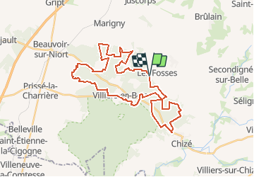
Randonnée V.T.T. de 39 km à découvrir à Nouvelle-Aquitaine, Deux-Sèvres, Les Fosses. Cette randonnée est proposée par tracegps.
Description
Très belle randonnée dans la forêt de Chizé. Parcours exclusivement dans les bois. Ce circuit longe le zoo de Chizé ainsi que la Réserve Biologique Intégrale de l'Office National des Forêts. Ce site préservé fait partie des sites Natura 2000.
Localisation
Pays :
France
Région :
Nouvelle-Aquitaine
Département/Province :
Deux-Sèvres
Commune :
Les Fosses
Localité :
Unknown
Départ:(Dec)
Départ:(UTM)
702414 ; 5115383 (30T) N.
Commentaires
Randonnées à proximité
![Randonnée Marche Brûlain - Brulain - Photo](https://media.geolcdn.com/t/375/260/a9519399-286c-45c2-aa5f-a934bfab26c8.png&format=jpg&maxdim=2)
![Marche Marche](https://static1.geolcdn.com/sitytour/trail-icons/101.png)
Brulain
Marche
Facile
Brûlain,
Nouvelle-Aquitaine,
Deux-Sèvres,
France
![](/images/other/stat-length.png)
8,4 km | 9,1 km-effort
2h 20min
![](https://static1.geolcdn.com/siteimages/upload/files/16400158638029165_repeat_loop_refresh_sync_direction_icon.png)
Oui
![Randonnée sport Les Fosses - REA Vendée GPX - Photo](https://media.geolcdn.com/t/375/260/ext.jpg?maxdim=2&url=https%3A%2F%2Fsecurestorage.geolives.com%2Fsitytour%2Ftrail-bg%2Fdefault.jpg)
REA Vendée GPX
sport
Très facile
Les Fosses,
Nouvelle-Aquitaine,
Deux-Sèvres,
France
![](/images/other/stat-length.png)
229 km | 262 km-effort
Inconnu
![](https://static1.geolcdn.com/siteimages/upload/files/16400158638029165_repeat_loop_refresh_sync_direction_icon.png)
Non
![Randonnée Marche Brûlain - Brûlain 8,6 km - Photo](https://media.geolcdn.com/t/375/260/ext.jpg?maxdim=2&url=https%3A%2F%2Fstatic1.geolcdn.com%2Fsiteimages%2Fupload%2Ffiles%2F1553511878bg_sport_marche.png)
![Marche Marche](https://static1.geolcdn.com/sitytour/trail-icons/101.png)
Brûlain 8,6 km
Marche
Facile
Brûlain,
Nouvelle-Aquitaine,
Deux-Sèvres,
France
![](/images/other/stat-length.png)
8,6 km | 9,2 km-effort
2h 2min
![](https://static1.geolcdn.com/siteimages/upload/files/16400158638029165_repeat_loop_refresh_sync_direction_icon.png)
Oui
![Randonnée Marche Marigny - Marigny - Photo](https://media.geolcdn.com/t/375/260/ext.jpg?maxdim=2&url=https%3A%2F%2Fstatic1.geolcdn.com%2Fsiteimages%2Fupload%2Ffiles%2F1553511878bg_sport_marche.png)
![Marche Marche](https://static1.geolcdn.com/sitytour/trail-icons/101.png)
Marigny
Marche
Facile
Marigny,
Nouvelle-Aquitaine,
Deux-Sèvres,
France
![](/images/other/stat-length.png)
7,8 km | 8,6 km-effort
2h 7min
![](https://static1.geolcdn.com/siteimages/upload/files/16400158638029165_repeat_loop_refresh_sync_direction_icon.png)
Oui
![Randonnée Marche Marigny - tgf - Photo](https://media.geolcdn.com/t/375/260/ext.jpg?maxdim=2&url=https%3A%2F%2Fstatic1.geolcdn.com%2Fsiteimages%2Fupload%2Ffiles%2F1553511878bg_sport_marche.png)
![Marche Marche](https://static1.geolcdn.com/sitytour/trail-icons/101.png)
tgf
Marche
Moyen
Marigny,
Nouvelle-Aquitaine,
Deux-Sèvres,
France
![](/images/other/stat-length.png)
7,9 km | 8,8 km-effort
1h 45min
![](https://static1.geolcdn.com/siteimages/upload/files/16400158638029165_repeat_loop_refresh_sync_direction_icon.png)
Oui
![Randonnée Marche Marigny - chize - Photo](https://media.geolcdn.com/t/375/260/ext.jpg?maxdim=2&url=https%3A%2F%2Fstatic1.geolcdn.com%2Fsiteimages%2Fupload%2Ffiles%2F1553511878bg_sport_marche.png)
![Marche Marche](https://static1.geolcdn.com/sitytour/trail-icons/101.png)
chize
Marche
Moyen
Marigny,
Nouvelle-Aquitaine,
Deux-Sèvres,
France
![](/images/other/stat-length.png)
6,6 km | 7,3 km-effort
1h 43min
![](https://static1.geolcdn.com/siteimages/upload/files/16400158638029165_repeat_loop_refresh_sync_direction_icon.png)
Oui
![Randonnée Marche Marigny - chize - Photo](https://media.geolcdn.com/t/375/260/ext.jpg?maxdim=2&url=https%3A%2F%2Fstatic1.geolcdn.com%2Fsiteimages%2Fupload%2Ffiles%2F1553511878bg_sport_marche.png)
![Marche Marche](https://static1.geolcdn.com/sitytour/trail-icons/101.png)
chize
Marche
Moyen
Marigny,
Nouvelle-Aquitaine,
Deux-Sèvres,
France
![](/images/other/stat-length.png)
6,7 km | 7,3 km-effort
1h 38min
![](https://static1.geolcdn.com/siteimages/upload/files/16400158638029165_repeat_loop_refresh_sync_direction_icon.png)
Oui
![Randonnée Marche Villiers-en-Bois - gghy - Photo](https://media.geolcdn.com/t/375/260/ext.jpg?maxdim=2&url=https%3A%2F%2Fstatic1.geolcdn.com%2Fsiteimages%2Fupload%2Ffiles%2F1553511878bg_sport_marche.png)
![Marche Marche](https://static1.geolcdn.com/sitytour/trail-icons/101.png)
gghy
Marche
Très facile
Villiers-en-Bois,
Nouvelle-Aquitaine,
Deux-Sèvres,
France
![](/images/other/stat-length.png)
6,1 km | 6,8 km-effort
1h 41min
![](https://static1.geolcdn.com/siteimages/upload/files/16400158638029165_repeat_loop_refresh_sync_direction_icon.png)
Non
![Randonnée Marche Villiers-en-Bois - ff - Photo](https://media.geolcdn.com/t/375/260/ext.jpg?maxdim=2&url=https%3A%2F%2Fstatic1.geolcdn.com%2Fsiteimages%2Fupload%2Ffiles%2F1553511878bg_sport_marche.png)
![Marche Marche](https://static1.geolcdn.com/sitytour/trail-icons/101.png)
ff
Marche
Très facile
Villiers-en-Bois,
Nouvelle-Aquitaine,
Deux-Sèvres,
France
![](/images/other/stat-length.png)
6,1 km | 6,8 km-effort
1h 41min
![](https://static1.geolcdn.com/siteimages/upload/files/16400158638029165_repeat_loop_refresh_sync_direction_icon.png)
Non