![](/images/other/stat-length.png)
![Randonnée V.T.T. Charchilla - Charchilla - Coyron - lac de Vouglans - Photo](https://media.geolcdn.com/t/1900/400/ext.pjpeg?maxdim=2&url=https%3A%2F%2Fservices.sitytrail.com%2FGeolivesWS%2FDownloadMedia.ashx%3FTrailID%3D106121%26Media%3D10356_1.jpg)
Charchilla - Coyron - lac de Vouglans
tracegps
Utilisateur
![Longueur](/images/other/stat-length.png)
![Altitude max](https://static1.geolcdn.com/siteimages/upload/files/1508320355ic_sort_altitude_max_24dp.png)
![Dénivelé positif](https://static1.geolcdn.com/siteimages/upload/files/1508320355ic_sort_den_pos_24dp.png)
![Km-Effort](/images/other/stat-length.png)
![Altitude min](https://static1.geolcdn.com/siteimages/upload/files/1508320355ic_sort_altitude_min_24dp.png)
![Dénivelé négatif](https://static1.geolcdn.com/siteimages/upload/files/1508320355ic_sort_den_neg_24dp.png)
![Boucle](https://static1.geolcdn.com/siteimages/upload/files/16400158638029165_repeat_loop_refresh_sync_direction_icon.png)
![V.T.T.](https://static1.geolcdn.com/sitytour/trail-icons/202.png)
2h15
Difficulté : Moyen
![Scannez ce code QR pour ouvrir la randonnée dans l'application SityTrail](https://capi.geolives.com/qq0zvz2zws4bq2lad0pu/sitytour/trails/106121/qr.png?size=200)
Application GPS de randonnée GRATUITE
À propos
Randonnée V.T.T. de 24 km à découvrir à Bourgogne-Franche-Comté, Jura, Charchilla. Cette randonnée est proposée par tracegps.
Description
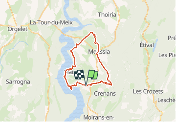
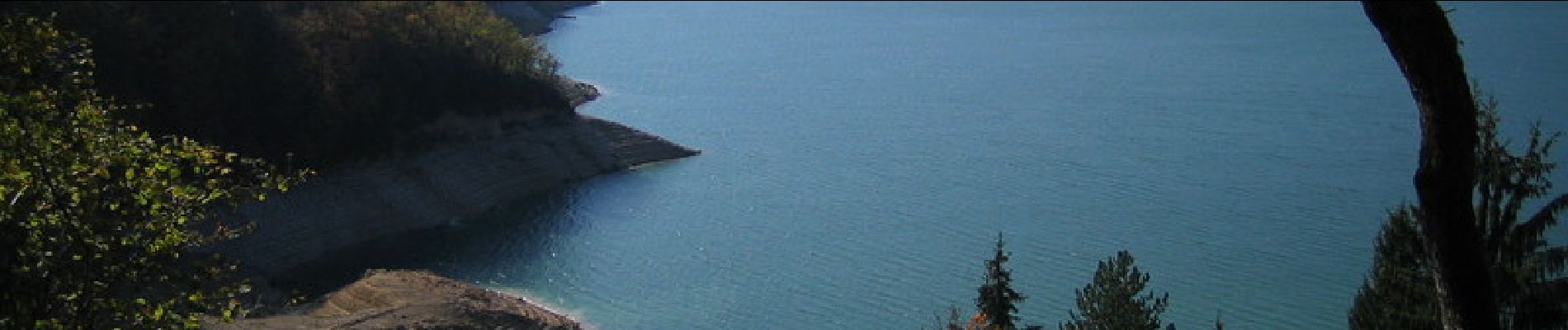
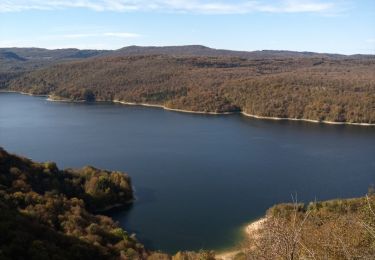
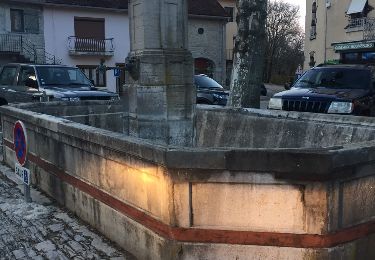
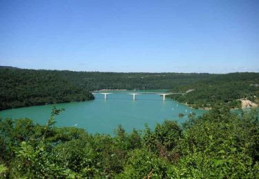
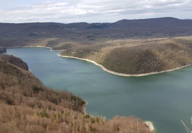
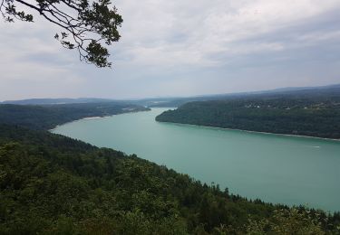
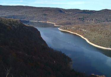
Rando assez facile départ de l'église de Charchilla. Passage à Coulouvre, Meussia, Coyron, puis on longe le lac de Vouglans jusqu'à la Mercentine. Attention, le circuit ici emprunte sur environ 300m un sentier interdit aux vélos (entre le village vacances de la Mercantine et la plage) il faut donc descendre du VTT pour cette partie du sentier, surtout en saison touristique. Cette balade a une longueur totale indicative de 23.786 km. L'enregistrement du tracé a été fait en moyenne tous les 13 m. Les variations d'altitudes (dénivelés) sont en gros respectivement de 1051 m et de -1050 m. Cette balade démarre à 578 m pour grosso modo 1.7 km de montées, 2.1 km de descentes et 20 km de plats ! Le point culminant de la balade est proche de 759 m (et le plus bas à 424 m). La balade est datée du 24/10/2009. Sa durée a été de 02h25m57s, avec une vitesse moyenne de 9.8 km/h (avec beaucoup d'arrêts).
Localisation
Commentaires
Randonnées à proximité
![Randonnée Marche Moirans-en-Montagne - Le Regardoir - Photo](https://media.geolcdn.com/t/375/260/2e2d2c64-b4bd-48ba-80a1-644324bc25bf.jpg&format=jpg&maxdim=2)
![Marche Marche](https://static1.geolcdn.com/sitytour/trail-icons/101.png)
Marche
![](/images/other/stat-length.png)
![](https://static1.geolcdn.com/siteimages/upload/files/16400158638029165_repeat_loop_refresh_sync_direction_icon.png)
![Randonnée Randonnée équestre Moirans-en-Montagne - Jura_moirans_J1 - Photo](https://media.geolcdn.com/t/375/260/ext.jpg?maxdim=2&url=https%3A%2F%2Fstatic1.geolcdn.com%2Fsiteimages%2Fupload%2Ffiles%2F1524743154cheval.jpg)
![Randonnée équestre Randonnée équestre](https://static1.geolcdn.com/sitytour/trail-icons/301.png)
Randonnée équestre
![](/images/other/stat-length.png)
![](https://static1.geolcdn.com/siteimages/upload/files/16400158638029165_repeat_loop_refresh_sync_direction_icon.png)
![Randonnée Marche Meussia - Meussia - Photo](https://media.geolcdn.com/t/375/260/d815ae6e-132a-42ac-bba3-0bb6a7b03dc8.jpg&format=jpg&maxdim=2)
![Marche Marche](https://static1.geolcdn.com/sitytour/trail-icons/101.png)
Marche
![](/images/other/stat-length.png)
![](https://static1.geolcdn.com/siteimages/upload/files/16400158638029165_repeat_loop_refresh_sync_direction_icon.png)
![Randonnée Marche Moirans-en-Montagne - d)Etapa 4 - Photo](https://media.geolcdn.com/t/375/260/ext.jpg?maxdim=2&url=https%3A%2F%2Fservices.sitytrail.com%2FGeolivesWS%2FDownloadMedia.ashx%3FTrailID%3D710982%26Media%3D20170302181916.jpg)
![Marche Marche](https://static1.geolcdn.com/sitytour/trail-icons/101.png)
Marche
![](/images/other/stat-length.png)
![](https://static1.geolcdn.com/siteimages/upload/files/16400158638029165_repeat_loop_refresh_sync_direction_icon.png)
![Randonnée Marche Coyron - Rando Vouglans - Photo](https://media.geolcdn.com/t/375/260/ext.jpg?maxdim=2&url=https%3A%2F%2Fservices.sitytrail.com%2FGeolivesWS%2FDownloadMedia.ashx%3FTrailID%3D364191%26Media%3Dfix__20141120142636.jpg)
![Marche Marche](https://static1.geolcdn.com/sitytour/trail-icons/101.png)
Marche
![](/images/other/stat-length.png)
![](https://static1.geolcdn.com/siteimages/upload/files/16400158638029165_repeat_loop_refresh_sync_direction_icon.png)
![Randonnée V.T.T. Maisod - Lac de Vouglans sud - Maisod - Photo](https://media.geolcdn.com/t/375/260/ext.jpg?maxdim=2&url=https%3A%2F%2Fservices.sitytrail.com%2FGeolivesWS%2FDownloadMedia.ashx%3FTrailID%3D316889%26Media%3D15973_4.jpg)
![V.T.T. V.T.T.](https://static1.geolcdn.com/sitytour/trail-icons/202.png)
V.T.T.
![](/images/other/stat-length.png)
![](https://static1.geolcdn.com/siteimages/upload/files/16400158638029165_repeat_loop_refresh_sync_direction_icon.png)
![Randonnée Marche Moirans-en-Montagne - Moirans-belvedere Palards - Photo](https://media.geolcdn.com/t/375/260/2d00733c-e5cc-4bb3-bf24-1880e7791bbe.jpg&format=jpg&maxdim=2)
![Marche Marche](https://static1.geolcdn.com/sitytour/trail-icons/101.png)
Marche
![](/images/other/stat-length.png)
![](https://static1.geolcdn.com/siteimages/upload/files/16400158638029165_repeat_loop_refresh_sync_direction_icon.png)
![Randonnée Marche Onoz - Vouglans - Les Bourlaches - Photo](https://media.geolcdn.com/t/375/260/6e14a6df-fe36-46d3-a23f-a2926a164097.jpg&format=jpg&maxdim=2)
![Marche Marche](https://static1.geolcdn.com/sitytour/trail-icons/101.png)
Marche
![](/images/other/stat-length.png)
![](https://static1.geolcdn.com/siteimages/upload/files/16400158638029165_repeat_loop_refresh_sync_direction_icon.png)
![Randonnée Marche Moirans-en-Montagne - Moirans La grande lésine - Photo](https://media.geolcdn.com/t/375/260/79580951-6c6e-4c19-8221-1b36af068b1a.jpg&format=jpg&maxdim=2)
![Marche Marche](https://static1.geolcdn.com/sitytour/trail-icons/101.png)
Marche
![](/images/other/stat-length.png)
![](https://static1.geolcdn.com/siteimages/upload/files/16400158638029165_repeat_loop_refresh_sync_direction_icon.png)