![](/images/other/stat-length.png)
![Randonnée Course à pied Rognac - Arbois - Croix de Rognac - Photo](https://media.geolcdn.com/t/1900/400/ext.pjpeg?maxdim=2&url=https%3A%2F%2Fservices.sitytrail.com%2FGeolivesWS%2FDownloadMedia.ashx%3FTrailID%3D106112%26Media%3D10345_1.jpg)
Arbois - Croix de Rognac
tracegps
Utilisateur
![Longueur](/images/other/stat-length.png)
![Altitude max](https://static1.geolcdn.com/siteimages/upload/files/1508320355ic_sort_altitude_max_24dp.png)
![Dénivelé positif](https://static1.geolcdn.com/siteimages/upload/files/1508320355ic_sort_den_pos_24dp.png)
![Km-Effort](/images/other/stat-length.png)
![Altitude min](https://static1.geolcdn.com/siteimages/upload/files/1508320355ic_sort_altitude_min_24dp.png)
![Dénivelé négatif](https://static1.geolcdn.com/siteimages/upload/files/1508320355ic_sort_den_neg_24dp.png)
![Boucle](https://static1.geolcdn.com/siteimages/upload/files/16400158638029165_repeat_loop_refresh_sync_direction_icon.png)
![Course à pied](https://static1.geolcdn.com/sitytour/trail-icons/103.png)
1h04
Difficulté : Moyen
![Scannez ce code QR pour ouvrir la randonnée dans l'application SityTrail](https://capi.geolives.com/qq0zvz2zws4bq2lad0pu/sitytour/trails/106112/qr.png?size=200)
Application GPS de randonnée GRATUITE
À propos
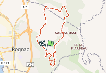
Randonnée Course à pied de 9 km à découvrir à Provence-Alpes-Côte d'Azur, Bouches-du-Rhône, Rognac. Cette randonnée est proposée par tracegps.
Description
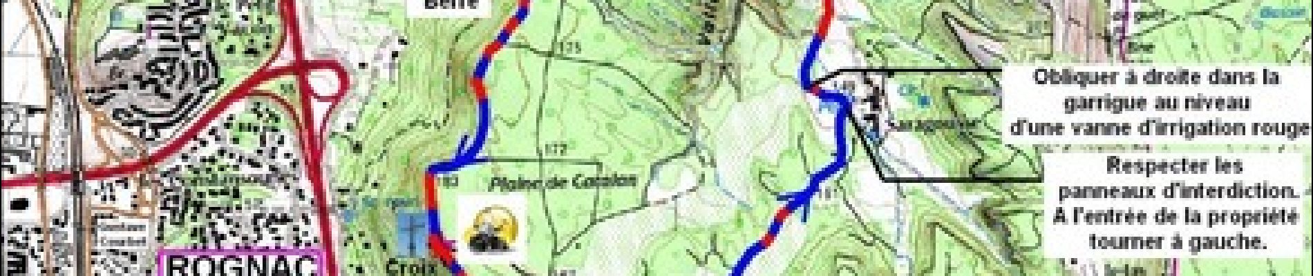
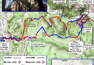
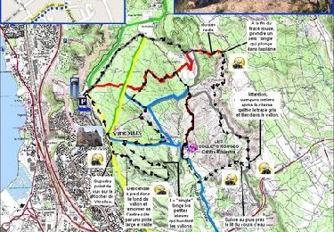
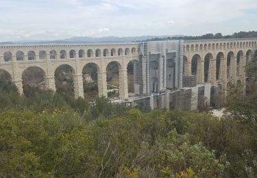
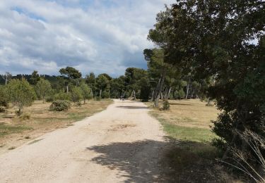
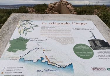
Aujourd'hui on va tourner au départ de Rognac : En venant de Marseille prendre l'autoroute A7 direction Lyon et sortir à Rognac. Prendre le boulevard Gustave Courbet, puis l'avenue Frédéric Mistral et l'avenue de Sarragousse, jusqu'à un premier parking avec une large citerne incendie. Allez faire ce parcours après de fortes pluies pour avoir la chance de voir couler la cascade de l'Oule. Appréciez le jeu des oiseaux dans les ascendants qui remontent le long des falaises, associé à la vue sur l'Étang de Berre, ça promet un super footing.
Localisation
Commentaires
Randonnées à proximité
![Randonnée Course à pied Velaux - Aqueduc de Roquefavour - Velaux - Photo](https://media.geolcdn.com/t/375/260/ext.jpg?maxdim=2&url=https%3A%2F%2Fservices.sitytrail.com%2FGeolivesWS%2FDownloadMedia.ashx%3FTrailID%3D107175%26Media%3D12024_1.jpg)
![Course à pied Course à pied](https://static1.geolcdn.com/sitytour/trail-icons/103.png)
Course à pied
![](/images/other/stat-length.png)
![](https://static1.geolcdn.com/siteimages/upload/files/16400158638029165_repeat_loop_refresh_sync_direction_icon.png)
![Randonnée V.T.T. Vitrolles - Vitrolles - les Collets Rouges - Photo](https://media.geolcdn.com/t/375/260/ext.jpg?maxdim=2&url=https%3A%2F%2Fservices.sitytrail.com%2FGeolivesWS%2FDownloadMedia.ashx%3FTrailID%3D104784%26Media%3D8243_1.jpg)
![V.T.T. V.T.T.](https://static1.geolcdn.com/sitytour/trail-icons/202.png)
V.T.T.
![](/images/other/stat-length.png)
![](https://static1.geolcdn.com/siteimages/upload/files/16400158638029165_repeat_loop_refresh_sync_direction_icon.png)
![Randonnée Marche Ventabren - Ventabren - Chante-grillet - Roquefavour - Photo](https://media.geolcdn.com/t/375/260/491778aa-d845-4d2d-b1d2-4fd6f906d2d3.jpg&format=jpg&maxdim=2)
![Marche Marche](https://static1.geolcdn.com/sitytour/trail-icons/101.png)
Marche
![](/images/other/stat-length.png)
![](https://static1.geolcdn.com/siteimages/upload/files/16400158638029165_repeat_loop_refresh_sync_direction_icon.png)
![Randonnée Marche Rognac - Vallon de Mion - Photo](https://media.geolcdn.com/t/375/260/02b7a81f-7cc4-4f03-96c2-caf1d5375314.jpg&format=jpg&maxdim=2)
![Marche Marche](https://static1.geolcdn.com/sitytour/trail-icons/101.png)
Marche
![](/images/other/stat-length.png)
![](https://static1.geolcdn.com/siteimages/upload/files/16400158638029165_repeat_loop_refresh_sync_direction_icon.png)
![Randonnée Marche Vitrolles - autour du Radar - Photo](https://media.geolcdn.com/t/375/260/63c53e32-fdf0-4b77-9e4c-221758388da7.jpg&format=jpg&maxdim=2)
![Marche Marche](https://static1.geolcdn.com/sitytour/trail-icons/101.png)
Marche
![](/images/other/stat-length.png)
![](https://static1.geolcdn.com/siteimages/upload/files/16400158638029165_repeat_loop_refresh_sync_direction_icon.png)
![Randonnée Marche Vitrolles - Plateau de Vitrolles-Tour du Pouchon - Photo](https://media.geolcdn.com/t/375/260/e86bdb15-1b97-4028-aa2f-2f6c3adb17d4.jpg&format=jpg&maxdim=2)
![Marche Marche](https://static1.geolcdn.com/sitytour/trail-icons/101.png)
Marche
![](/images/other/stat-length.png)
![](https://static1.geolcdn.com/siteimages/upload/files/16400158638029165_repeat_loop_refresh_sync_direction_icon.png)
![Randonnée Marche Vitrolles - plateau Vitrolles sud est - Photo](https://media.geolcdn.com/t/375/260/5d01fee6-b4af-4a8f-a7dd-39dd9965bd01.jpg&format=jpg&maxdim=2)
![Marche Marche](https://static1.geolcdn.com/sitytour/trail-icons/101.png)
Marche
![](/images/other/stat-length.png)
![](https://static1.geolcdn.com/siteimages/upload/files/16400158638029165_repeat_loop_refresh_sync_direction_icon.png)
![Randonnée Marche Rognac - Tour du domaine de la Saragousse - Photo](https://media.geolcdn.com/t/375/260/7a65468a-933e-4e0e-8721-c8ced74b7ed0.jpg&format=jpg&maxdim=2)
![Marche Marche](https://static1.geolcdn.com/sitytour/trail-icons/101.png)
Marche
![](/images/other/stat-length.png)
![](https://static1.geolcdn.com/siteimages/upload/files/16400158638029165_repeat_loop_refresh_sync_direction_icon.png)
![Randonnée Marche Vitrolles - les Crêtes de l'arbois - Photo](https://media.geolcdn.com/t/375/260/61a09577-ac40-4dc1-a092-6be4a3bd2211.jpg&format=jpg&maxdim=2)
![Marche Marche](https://static1.geolcdn.com/sitytour/trail-icons/101.png)
Marche
![](/images/other/stat-length.png)
![](https://static1.geolcdn.com/siteimages/upload/files/16400158638029165_repeat_loop_refresh_sync_direction_icon.png)