![](/images/other/stat-length.png)
![Randonnée V.T.T. Mens - La Croix de Charvet - Mens - Photo](https://media.geolcdn.com/t/1900/400/ext.pjpeg?maxdim=2&url=https%3A%2F%2Fstatic1.geolcdn.com%2Fsiteimages%2Fupload%2Ffiles%2F1524743154velo.jpg)
La Croix de Charvet - Mens
tracegps
Utilisateur
![Longueur](/images/other/stat-length.png)
![Altitude max](https://static1.geolcdn.com/siteimages/upload/files/1508320355ic_sort_altitude_max_24dp.png)
![Dénivelé positif](https://static1.geolcdn.com/siteimages/upload/files/1508320355ic_sort_den_pos_24dp.png)
![Km-Effort](/images/other/stat-length.png)
![Altitude min](https://static1.geolcdn.com/siteimages/upload/files/1508320355ic_sort_altitude_min_24dp.png)
![Dénivelé négatif](https://static1.geolcdn.com/siteimages/upload/files/1508320355ic_sort_den_neg_24dp.png)
![Boucle](https://static1.geolcdn.com/siteimages/upload/files/16400158638029165_repeat_loop_refresh_sync_direction_icon.png)
![V.T.T.](https://static1.geolcdn.com/sitytour/trail-icons/202.png)
42m
Difficulté : Moyen
![Scannez ce code QR pour ouvrir la randonnée dans l'application SityTrail](https://capi.geolives.com/qq0zvz2zws4bq2lad0pu/sitytour/trails/106030/qr.png?size=200)
Application GPS de randonnée GRATUITE
À propos
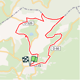
Randonnée V.T.T. de 9,9 km à découvrir à Auvergne-Rhône-Alpes, Isère, Mens. Cette randonnée est proposée par tracegps.
Description
Circuit n°2 (bleu) de la base VTT FFCT du Trièves. Un circuit très agréable au milieu des espaces ouverts et jardinés, qui permet d'avoir un aperçu du Trièves : mosaïque de couleurs, architecture ... A faire en toute saison pour admirer le paysage et le travail de l'agriculteur dans l'espace.
Localisation
Commentaires
Randonnées à proximité
![Randonnée Marche Mens - Bonnet Calvin reco - Photo](https://media.geolcdn.com/t/375/260/71237d58-2b29-4521-9351-2dded8929675.jpg&format=jpg&maxdim=2)
![Marche Marche](https://static1.geolcdn.com/sitytour/trail-icons/101.png)
Marche
![](/images/other/stat-length.png)
![](https://static1.geolcdn.com/siteimages/upload/files/16400158638029165_repeat_loop_refresh_sync_direction_icon.png)
![Randonnée Marche Saint-Baudille-et-Pipet - Bonnet de Calvin - Photo](https://media.geolcdn.com/t/375/260/b711d778-2624-48ca-9a09-33141db7aca2.jpg&format=jpg&maxdim=2)
![Marche Marche](https://static1.geolcdn.com/sitytour/trail-icons/101.png)
Marche
![](/images/other/stat-length.png)
![](https://static1.geolcdn.com/siteimages/upload/files/16400158638029165_repeat_loop_refresh_sync_direction_icon.png)
![Randonnée Marche Saint-Baudille-et-Pipet - Des Lames d'Arçon au Col de l'Aiguille - Photo](https://media.geolcdn.com/t/375/260/6a7d919f-0a46-4fb6-a03a-1cd4dec1d339.jpg&format=jpg&maxdim=2)
![Marche Marche](https://static1.geolcdn.com/sitytour/trail-icons/101.png)
Marche
![](/images/other/stat-length.png)
![](https://static1.geolcdn.com/siteimages/upload/files/16400158638029165_repeat_loop_refresh_sync_direction_icon.png)
![Randonnée Marche Mens - bonnet de Calvin - Photo](https://media.geolcdn.com/t/375/260/809ecc75-03b4-4bae-9bda-776611be3043.jpg&format=jpg&maxdim=2)
![Marche Marche](https://static1.geolcdn.com/sitytour/trail-icons/101.png)
Marche
![](/images/other/stat-length.png)
![](https://static1.geolcdn.com/siteimages/upload/files/16400158638029165_repeat_loop_refresh_sync_direction_icon.png)
![Randonnée Marche Mens - Esclops Trièves Tour de Mens - Photo](https://media.geolcdn.com/t/375/260/009e9f5f-8365-4132-9701-b10e3311f406.jpg&format=jpg&maxdim=2)
![Marche Marche](https://static1.geolcdn.com/sitytour/trail-icons/101.png)
Marche
![](/images/other/stat-length.png)
![](https://static1.geolcdn.com/siteimages/upload/files/16400158638029165_repeat_loop_refresh_sync_direction_icon.png)
![Randonnée Marche Saint-Baudille-et-Pipet - Esclops Trièves Col de l'Aiguille - Photo](https://media.geolcdn.com/t/375/260/c1c5675d-bfe6-4e05-80f5-bbfac132efec.jpg&format=jpg&maxdim=2)
![Marche Marche](https://static1.geolcdn.com/sitytour/trail-icons/101.png)
Marche
![](/images/other/stat-length.png)
![](https://static1.geolcdn.com/siteimages/upload/files/16400158638029165_repeat_loop_refresh_sync_direction_icon.png)
![Randonnée Marche Saint-Baudille-et-Pipet - Col de la l'Aiguille - Photo](https://media.geolcdn.com/t/375/260/2743f076-6474-4350-bcdf-a04402ad0013.jpg&format=jpg&maxdim=2)
![Marche Marche](https://static1.geolcdn.com/sitytour/trail-icons/101.png)
Marche
![](/images/other/stat-length.png)
![](https://static1.geolcdn.com/siteimages/upload/files/16400158638029165_repeat_loop_refresh_sync_direction_icon.png)
![Randonnée Vélo électrique Saint-Baudille-et-Pipet - Sainte Baudille de Pipet - St Pancrasse - Photo](https://media.geolcdn.com/t/375/260/98775b0d-8be1-4414-b804-8cc2ea33e09e.jpg&format=jpg&maxdim=2)
![Vélo électrique Vélo électrique](https://static1.geolcdn.com/sitytour/trail-icons/205.png)
Vélo électrique
![](/images/other/stat-length.png)
![](https://static1.geolcdn.com/siteimages/upload/files/16400158638029165_repeat_loop_refresh_sync_direction_icon.png)
![Randonnée Marche Mens - bonnet de Calvin - Photo](https://media.geolcdn.com/t/375/260/e0867dac-c8ad-4bc3-be49-12c40a0ad975.jpg&format=jpg&maxdim=2)
![Marche Marche](https://static1.geolcdn.com/sitytour/trail-icons/101.png)
Marche
![](/images/other/stat-length.png)
![](https://static1.geolcdn.com/siteimages/upload/files/16400158638029165_repeat_loop_refresh_sync_direction_icon.png)