![](/images/other/stat-length.png)
![Randonnée Cheval Pierrefort - Pierrefort - Montrosier - Chabridet - Photo](https://media.geolcdn.com/t/1900/400/ext.pjpeg?maxdim=2&url=https%3A%2F%2Fservices.sitytrail.com%2FGeolivesWS%2FDownloadMedia.ashx%3FTrailID%3D105993%26Media%3D10111_2.jpg)
Pierrefort - Montrosier - Chabridet
tracegps
Utilisateur
![Longueur](/images/other/stat-length.png)
Longueur
17,9 km
![Altitude max](https://static1.geolcdn.com/siteimages/upload/files/1508320355ic_sort_altitude_max_24dp.png)
Altitude max
1112 m
![Dénivelé positif](https://static1.geolcdn.com/siteimages/upload/files/1508320355ic_sort_den_pos_24dp.png)
Dénivelé positif
351 m
![Km-Effort](/images/other/stat-length.png)
Km-Effort
23 km
![Altitude min](https://static1.geolcdn.com/siteimages/upload/files/1508320355ic_sort_altitude_min_24dp.png)
Altitude min
910 m
![Dénivelé négatif](https://static1.geolcdn.com/siteimages/upload/files/1508320355ic_sort_den_neg_24dp.png)
Dénivelé négatif
351 m
![Boucle](https://static1.geolcdn.com/siteimages/upload/files/16400158638029165_repeat_loop_refresh_sync_direction_icon.png)
Boucle
Oui
Date de création :
2014-12-10 00:00:00.0
Dernière modification :
2014-12-10 00:00:00.0
![Cheval](https://static1.geolcdn.com/sitytour/trail-icons/300.png)
3h00
Difficulté : Moyen
![Scannez ce code QR pour ouvrir la randonnée dans l'application SityTrail](https://capi.geolives.com/qq0zvz2zws4bq2lad0pu/sitytour/trails/105993/qr.png?size=200)
Application GPS de randonnée GRATUITE
À propos
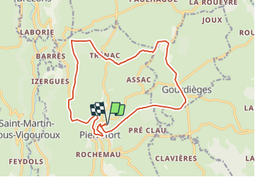
Randonnée Cheval de 17,9 km à découvrir à Auvergne-Rhône-Alpes, Cantal, Pierrefort. Cette randonnée est proposée par tracegps.
Description
Circuit partant de Pierrefort (15), très facile, chemin en sable et petits cailloux, quelques petites routes à traverser, des bois (Chabridet et Montrosier), chemin bien large, on ne peut pas le perdre.
Localisation
Pays :
France
Région :
Auvergne-Rhône-Alpes
Département/Province :
Cantal
Commune :
Pierrefort
Localité :
Unknown
Départ:(Dec)
Départ:(UTM)
487608 ; 4974590 (31T) N.
Commentaires
Randonnées à proximité
![Randonnée V.T.T. Pierrefort - Pierrefort - Montrosier - Chabridet - Photo](https://media.geolcdn.com/t/375/260/ext.jpg?maxdim=2&url=https%3A%2F%2Fservices.sitytrail.com%2FGeolivesWS%2FDownloadMedia.ashx%3FTrailID%3D105992%26Media%3D10111_2.jpg)
![V.T.T. V.T.T.](https://static1.geolcdn.com/sitytour/trail-icons/202.png)
Pierrefort - Montrosier - Chabridet
V.T.T.
Moyen
Pierrefort,
Auvergne-Rhône-Alpes,
Cantal,
France
![](/images/other/stat-length.png)
17,9 km | 23 km-effort
1h 30min
![](https://static1.geolcdn.com/siteimages/upload/files/16400158638029165_repeat_loop_refresh_sync_direction_icon.png)
Oui
![Randonnée Marche Pierrefort - Pierrefort - Montrosier - Chabridet - Photo](https://media.geolcdn.com/t/375/260/ext.jpg?maxdim=2&url=https%3A%2F%2Fservices.sitytrail.com%2FGeolivesWS%2FDownloadMedia.ashx%3FTrailID%3D105991%26Media%3D10111_2.jpg)
![Marche Marche](https://static1.geolcdn.com/sitytour/trail-icons/101.png)
Pierrefort - Montrosier - Chabridet
Marche
Moyen
Pierrefort,
Auvergne-Rhône-Alpes,
Cantal,
France
![](/images/other/stat-length.png)
17,9 km | 23 km-effort
4h 30min
![](https://static1.geolcdn.com/siteimages/upload/files/16400158638029165_repeat_loop_refresh_sync_direction_icon.png)
Oui
![Randonnée Marche Pierrefort - Vezou (Faverolles-Boussac) - Photo](https://media.geolcdn.com/t/375/260/ext.jpg?maxdim=2&url=https%3A%2F%2Fstatic1.geolcdn.com%2Fsiteimages%2Fupload%2Ffiles%2F1553511878bg_sport_marche.png)
![Marche Marche](https://static1.geolcdn.com/sitytour/trail-icons/101.png)
Vezou (Faverolles-Boussac)
Marche
Très facile
Pierrefort,
Auvergne-Rhône-Alpes,
Cantal,
France
![](/images/other/stat-length.png)
13,2 km | 18,5 km-effort
3h 51min
![](https://static1.geolcdn.com/siteimages/upload/files/16400158638029165_repeat_loop_refresh_sync_direction_icon.png)
Non
![Randonnée Marche Neuvéglise-sur-Truyère - La Roche Recoules - Photo](https://media.geolcdn.com/t/375/260/ext.jpg?maxdim=2&url=https%3A%2F%2Fstatic1.geolcdn.com%2Fsiteimages%2Fupload%2Ffiles%2F1553511878bg_sport_marche.png)
![Marche Marche](https://static1.geolcdn.com/sitytour/trail-icons/101.png)
La Roche Recoules
Marche
Très facile
Neuvéglise-sur-Truyère,
Auvergne-Rhône-Alpes,
Cantal,
France
![](/images/other/stat-length.png)
5 km | 6,7 km-effort
1h 51min
![](https://static1.geolcdn.com/siteimages/upload/files/16400158638029165_repeat_loop_refresh_sync_direction_icon.png)
Oui
![Randonnée Marche Pierrefort - le colombier le théron - Photo](https://media.geolcdn.com/t/375/260/ext.jpg?maxdim=2&url=https%3A%2F%2Fstatic1.geolcdn.com%2Fsiteimages%2Fupload%2Ffiles%2F1553511878bg_sport_marche.png)
![Marche Marche](https://static1.geolcdn.com/sitytour/trail-icons/101.png)
le colombier le théron
Marche
Très facile
Pierrefort,
Auvergne-Rhône-Alpes,
Cantal,
France
![](/images/other/stat-length.png)
4,4 km | 5,8 km-effort
1h 30min
![](https://static1.geolcdn.com/siteimages/upload/files/16400158638029165_repeat_loop_refresh_sync_direction_icon.png)
Oui
![Randonnée Marche Pierrefort - Le Monteil-Turlande - Photo](https://media.geolcdn.com/t/375/260/ext.jpg?maxdim=2&url=https%3A%2F%2Fstatic1.geolcdn.com%2Fsiteimages%2Fupload%2Ffiles%2F1553511878bg_sport_marche.png)
![Marche Marche](https://static1.geolcdn.com/sitytour/trail-icons/101.png)
Le Monteil-Turlande
Marche
Très facile
Pierrefort,
Auvergne-Rhône-Alpes,
Cantal,
France
![](/images/other/stat-length.png)
5,7 km | 6,6 km-effort
1h 24min
![](https://static1.geolcdn.com/siteimages/upload/files/16400158638029165_repeat_loop_refresh_sync_direction_icon.png)
Non
![Randonnée Marche Neuvéglise-sur-Truyère - laroche champs - Photo](https://media.geolcdn.com/t/375/260/ext.jpg?maxdim=2&url=https%3A%2F%2Fstatic1.geolcdn.com%2Fsiteimages%2Fupload%2Ffiles%2F1553511878bg_sport_marche.png)
![Marche Marche](https://static1.geolcdn.com/sitytour/trail-icons/101.png)
laroche champs
Marche
Facile
Neuvéglise-sur-Truyère,
Auvergne-Rhône-Alpes,
Cantal,
France
![](/images/other/stat-length.png)
3,6 km | 5 km-effort
1h 25min
![](https://static1.geolcdn.com/siteimages/upload/files/16400158638029165_repeat_loop_refresh_sync_direction_icon.png)
Oui
![Randonnée Marche Paulhenc - la garde-estradié - Photo](https://media.geolcdn.com/t/375/260/ext.jpg?maxdim=2&url=https%3A%2F%2Fstatic1.geolcdn.com%2Fsiteimages%2Fupload%2Ffiles%2F1553511878bg_sport_marche.png)
![Marche Marche](https://static1.geolcdn.com/sitytour/trail-icons/101.png)
la garde-estradié
Marche
Facile
Paulhenc,
Auvergne-Rhône-Alpes,
Cantal,
France
![](/images/other/stat-length.png)
2,8 km | 3,6 km-effort
59min
![](https://static1.geolcdn.com/siteimages/upload/files/16400158638029165_repeat_loop_refresh_sync_direction_icon.png)
Non
![Randonnée Vélo électrique Saint-Martin-sous-Vigouroux - 6_280423 - Photo](https://media.geolcdn.com/t/375/260/ext.jpg?maxdim=2&url=https%3A%2F%2Fstatic1.geolcdn.com%2Fsiteimages%2Fupload%2Ffiles%2F1524743154velo.jpg)
![Vélo électrique Vélo électrique](https://static1.geolcdn.com/sitytour/trail-icons/205.png)
6_280423
Vélo électrique
Difficile
Saint-Martin-sous-Vigouroux,
Auvergne-Rhône-Alpes,
Cantal,
France
![](/images/other/stat-length.png)
71 km | 90 km-effort
10h 6min
![](https://static1.geolcdn.com/siteimages/upload/files/16400158638029165_repeat_loop_refresh_sync_direction_icon.png)
Non