![](/images/other/stat-length.png)
![Randonnée Marche Chastellux-sur-Cure - Tour du Morvan pédestre - de Chastellux sur Cure à Brassy - Photo](https://media.geolcdn.com/t/1900/400/ext.pjpeg?maxdim=2&url=https%3A%2F%2Fstatic1.geolcdn.com%2Fsiteimages%2Fupload%2Ffiles%2F1553511878bg_sport_marche.png)
Tour du Morvan pédestre - de Chastellux sur Cure à Brassy
tracegps
Utilisateur
![Longueur](/images/other/stat-length.png)
Longueur
25 km
![Altitude max](https://static1.geolcdn.com/siteimages/upload/files/1508320355ic_sort_altitude_max_24dp.png)
Altitude max
515 m
![Dénivelé positif](https://static1.geolcdn.com/siteimages/upload/files/1508320355ic_sort_den_pos_24dp.png)
Dénivelé positif
708 m
![Km-Effort](/images/other/stat-length.png)
Km-Effort
34 km
![Altitude min](https://static1.geolcdn.com/siteimages/upload/files/1508320355ic_sort_altitude_min_24dp.png)
Altitude min
277 m
![Dénivelé négatif](https://static1.geolcdn.com/siteimages/upload/files/1508320355ic_sort_den_neg_24dp.png)
Dénivelé négatif
662 m
![Boucle](https://static1.geolcdn.com/siteimages/upload/files/16400158638029165_repeat_loop_refresh_sync_direction_icon.png)
Boucle
Non
Date de création :
2014-12-10 00:00:00.0
Dernière modification :
2014-12-10 00:00:00.0
![Marche](https://static1.geolcdn.com/sitytour/trail-icons/101.png)
7h00
Difficulté : Difficile
![Scannez ce code QR pour ouvrir la randonnée dans l'application SityTrail](https://capi.geolives.com/qq0zvz2zws4bq2lad0pu/sitytour/trails/105980/qr.png?size=200)
Application GPS de randonnée GRATUITE
À propos
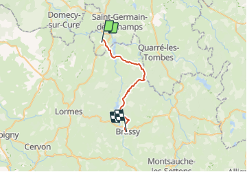
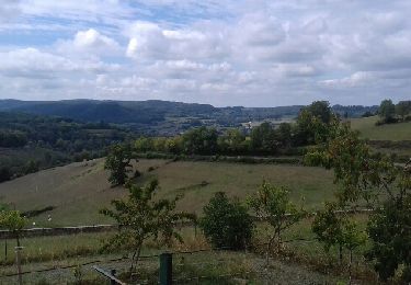
Randonnée Marche de 25 km à découvrir à Bourgogne-Franche-Comté, Yonne, Chastellux-sur-Cure. Cette randonnée est proposée par tracegps.
Description
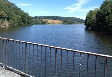
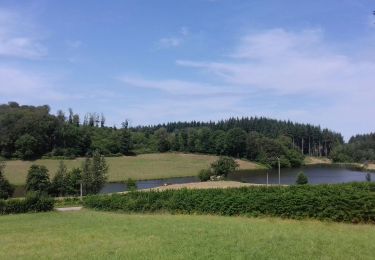
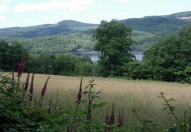
Passage auprès du Réservoir de Crescent, Marigny l’Eglise avant de remonter vers Mazignien et les bois. On longe le Réservoir de Chaumeçon puis descente vers Brassy.
Localisation
Pays :
France
Région :
Bourgogne-Franche-Comté
Département/Province :
Yonne
Commune :
Chastellux-sur-Cure
Localité :
Unknown
Départ:(Dec)
Départ:(UTM)
566810 ; 5248057 (31T) N.
Commentaires
Randonnées à proximité
![Randonnée Marche Saint-André-en-Morvan - SAINT-ANDRE-EN-MORVAN (9/20) - Photo](https://media.geolcdn.com/t/375/260/2afd1577-a731-4de7-8e6f-0fb7b3dcf911.jpg&format=jpg&maxdim=2)
![Marche Marche](https://static1.geolcdn.com/sitytour/trail-icons/101.png)
SAINT-ANDRE-EN-MORVAN (9/20)
Marche
Moyen
Saint-André-en-Morvan,
Bourgogne-Franche-Comté,
Nièvre,
France
![](/images/other/stat-length.png)
8,9 km | 11,8 km-effort
3h 15min
![](https://static1.geolcdn.com/siteimages/upload/files/16400158638029165_repeat_loop_refresh_sync_direction_icon.png)
Oui
![Randonnée Marche Saint-Martin-du-Puy - Montcrecon -lac de Crescent - Chalaux - 7/2020 - Photo](https://media.geolcdn.com/t/375/260/7ec1466e-0140-43b0-b094-33756f4e2f64.jpg&format=jpg&maxdim=2)
![Marche Marche](https://static1.geolcdn.com/sitytour/trail-icons/101.png)
Montcrecon -lac de Crescent - Chalaux - 7/2020
Marche
Moyen
(1)
Saint-Martin-du-Puy,
Bourgogne-Franche-Comté,
Nièvre,
France
![](/images/other/stat-length.png)
9,4 km | 12,5 km-effort
4h 6min
![](https://static1.geolcdn.com/siteimages/upload/files/16400158638029165_repeat_loop_refresh_sync_direction_icon.png)
Oui
![Randonnée Marche Saint-Martin-du-Puy - Tour de Saint-Martin-du-Puy - Photo](https://media.geolcdn.com/t/375/260/cd12d0b3-1bf4-4ccf-91e3-e459657988b1.jpg&format=jpg&maxdim=2)
![Marche Marche](https://static1.geolcdn.com/sitytour/trail-icons/101.png)
Tour de Saint-Martin-du-Puy
Marche
Moyen
Saint-Martin-du-Puy,
Bourgogne-Franche-Comté,
Nièvre,
France
![](/images/other/stat-length.png)
10,6 km | 13,8 km-effort
3h 53min
![](https://static1.geolcdn.com/siteimages/upload/files/16400158638029165_repeat_loop_refresh_sync_direction_icon.png)
Oui
![Randonnée Marche Marigny-l'Église - Marigny l'Eglise, Chalaux - Photo](https://media.geolcdn.com/t/375/260/ext.jpg?maxdim=2&url=https%3A%2F%2Fservices.sitytrail.com%2FGeolivesWS%2FDownloadMedia.ashx%3FTrailID%3D1042547%26Media%3Dfix__20180903130249.jpg)
![Marche Marche](https://static1.geolcdn.com/sitytour/trail-icons/101.png)
Marigny l'Eglise, Chalaux
Marche
Moyen
Marigny-l'Église,
Bourgogne-Franche-Comté,
Nièvre,
France
![](/images/other/stat-length.png)
10,7 km | 15 km-effort
3h 20min
![](https://static1.geolcdn.com/siteimages/upload/files/16400158638029165_repeat_loop_refresh_sync_direction_icon.png)
Oui
![Randonnée Marche Chastellux-sur-Cure - Le Tour du Morvan pédestre - Photo](https://media.geolcdn.com/t/375/260/ext.jpg?maxdim=2&url=https%3A%2F%2Fservices.sitytrail.com%2FGeolivesWS%2FDownloadMedia.ashx%3FTrailID%3D105875%26Media%3D9854_3.jpg)
![Marche Marche](https://static1.geolcdn.com/sitytour/trail-icons/101.png)
Le Tour du Morvan pédestre
Marche
Difficile
Chastellux-sur-Cure,
Bourgogne-Franche-Comté,
Yonne,
France
![](/images/other/stat-length.png)
265 km | 366 km-effort
125h 0min
![](https://static1.geolcdn.com/siteimages/upload/files/16400158638029165_repeat_loop_refresh_sync_direction_icon.png)
Non
![Randonnée Marche Marigny-l'Église - Marigny-l'Église et le Lac du Crescent - Photo](https://media.geolcdn.com/t/375/260/ext.jpg?maxdim=2&url=https%3A%2F%2Fservices.sitytrail.com%2FGeolivesWS%2FDownloadMedia.ashx%3FTrailID%3D105649%26Media%3D9451_2.jpg)
![Marche Marche](https://static1.geolcdn.com/sitytour/trail-icons/101.png)
Marigny-l'Église et le Lac du Crescent
Marche
Difficile
Marigny-l'Église,
Bourgogne-Franche-Comté,
Nièvre,
France
![](/images/other/stat-length.png)
13,9 km | 20 km-effort
3h 49min
![](https://static1.geolcdn.com/siteimages/upload/files/16400158638029165_repeat_loop_refresh_sync_direction_icon.png)
Oui
![Randonnée Cheval Chastellux-sur-Cure - lac de crescent - Photo](https://media.geolcdn.com/t/375/260/ext.jpg?maxdim=2&url=https%3A%2F%2Fstatic1.geolcdn.com%2Fsiteimages%2Fupload%2Ffiles%2F1524743154cheval.jpg)
![Cheval Cheval](https://static1.geolcdn.com/sitytour/trail-icons/300.png)
lac de crescent
Cheval
Très facile
Chastellux-sur-Cure,
Bourgogne-Franche-Comté,
Yonne,
France
![](/images/other/stat-length.png)
25 km | 33 km-effort
Inconnu
![](https://static1.geolcdn.com/siteimages/upload/files/16400158638029165_repeat_loop_refresh_sync_direction_icon.png)
Oui
![Randonnée V.T.T. Marigny-l'Église - Marigny Saulieu - Photo](https://media.geolcdn.com/t/375/260/ext.jpg?maxdim=2&url=https%3A%2F%2Fstatic1.geolcdn.com%2Fsiteimages%2Fupload%2Ffiles%2F1524743154velo.jpg)
![V.T.T. V.T.T.](https://static1.geolcdn.com/sitytour/trail-icons/202.png)
Marigny Saulieu
V.T.T.
Très difficile
Marigny-l'Église,
Bourgogne-Franche-Comté,
Nièvre,
France
![](/images/other/stat-length.png)
49 km | 62 km-effort
6h 24min
![](https://static1.geolcdn.com/siteimages/upload/files/16400158638029165_repeat_loop_refresh_sync_direction_icon.png)
Non
![Randonnée Marche Marigny-l'Église - RIF-04-22-3 du 18.04.2022 - Photo](https://media.geolcdn.com/t/375/260/ext.jpg?maxdim=2&url=https%3A%2F%2Fstatic1.geolcdn.com%2Fsiteimages%2Fupload%2Ffiles%2F1553511878bg_sport_marche.png)
![Marche Marche](https://static1.geolcdn.com/sitytour/trail-icons/101.png)
RIF-04-22-3 du 18.04.2022
Marche
Facile
Marigny-l'Église,
Bourgogne-Franche-Comté,
Nièvre,
France
![](/images/other/stat-length.png)
14,9 km | 19,5 km-effort
4h 48min
![](https://static1.geolcdn.com/siteimages/upload/files/16400158638029165_repeat_loop_refresh_sync_direction_icon.png)
Non