![](/images/other/stat-length.png)
![Randonnée Marche Plouaret - Loc Ivy St Carré - Plouaret - Photo](https://media.geolcdn.com/t/1900/400/ext.pjpeg?maxdim=2&url=https%3A%2F%2Fservices.sitytrail.com%2FGeolivesWS%2FDownloadMedia.ashx%3FTrailID%3D105902%26Media%3D9900_6.jpg)
Loc Ivy St Carré - Plouaret
tracegps
Utilisateur
![Longueur](/images/other/stat-length.png)
Longueur
15,2 km
![Altitude max](https://static1.geolcdn.com/siteimages/upload/files/1508320355ic_sort_altitude_max_24dp.png)
Altitude max
216 m
![Dénivelé positif](https://static1.geolcdn.com/siteimages/upload/files/1508320355ic_sort_den_pos_24dp.png)
Dénivelé positif
204 m
![Km-Effort](/images/other/stat-length.png)
Km-Effort
18 km
![Altitude min](https://static1.geolcdn.com/siteimages/upload/files/1508320355ic_sort_altitude_min_24dp.png)
Altitude min
106 m
![Dénivelé négatif](https://static1.geolcdn.com/siteimages/upload/files/1508320355ic_sort_den_neg_24dp.png)
Dénivelé négatif
206 m
![Boucle](https://static1.geolcdn.com/siteimages/upload/files/16400158638029165_repeat_loop_refresh_sync_direction_icon.png)
Boucle
Oui
Date de création :
2014-12-10 00:00:00.0
Dernière modification :
2014-12-10 00:00:00.0
![Marche](https://static1.geolcdn.com/sitytour/trail-icons/101.png)
3h49
Difficulté : Difficile
![Scannez ce code QR pour ouvrir la randonnée dans l'application SityTrail](https://capi.geolives.com/qq0zvz2zws4bq2lad0pu/sitytour/trails/105902/qr.png?size=200)
Application GPS de randonnée GRATUITE
À propos
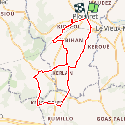
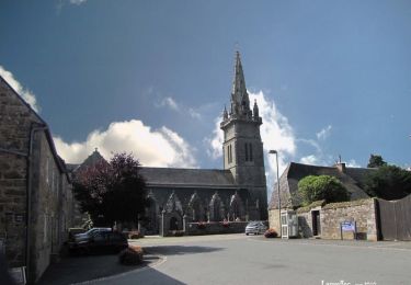
Randonnée Marche de 15,2 km à découvrir à Bretagne, Côtes-d'Armor, Plouaret. Cette randonnée est proposée par tracegps.
Description
Circuit proposé par l’association Henchou Don Lanvaeleg. Départ place de l'église ou parking de la salle des fêtes de Plouaret. Ce circuit vous fera passer par 4 communes : Plouaret, Lanvellec (St Carré), Plounérin et Plounévez Moëdec.
Localisation
Pays :
France
Région :
Bretagne
Département/Province :
Côtes-d'Armor
Commune :
Plouaret
Localité :
Unknown
Départ:(Dec)
Départ:(UTM)
465158 ; 5384403 (30U) N.
Commentaires
Randonnées à proximité
![Randonnée A pied Le Vieux-Marché - Moulin de Keranné- Belle Ile en terre - Photo](https://media.geolcdn.com/t/375/260/fef56ef2-9542-446d-b899-650effdff1a9.jpg&format=jpg&maxdim=2)
![A pied A pied](https://static1.geolcdn.com/sitytour/trail-icons/100.png)
Moulin de Keranné- Belle Ile en terre
A pied
Moyen
Le Vieux-Marché,
Bretagne,
Côtes-d'Armor,
France
![](/images/other/stat-length.png)
24 km | 31 km-effort
6h 56min
![](https://static1.geolcdn.com/siteimages/upload/files/16400158638029165_repeat_loop_refresh_sync_direction_icon.png)
Non
![Randonnée Marche Lanvellec - Lanvellec - Photo](https://media.geolcdn.com/t/375/260/ext.jpg?maxdim=2&url=https%3A%2F%2Fservices.sitytrail.com%2FGeolivesWS%2FDownloadMedia.ashx%3FTrailID%3D976018%26Media%3Dfix__20180521162811.jpg)
![Marche Marche](https://static1.geolcdn.com/sitytour/trail-icons/101.png)
![Randonnée Marche Plouaret - Boucle Plouaret à Maudez - Photo](https://media.geolcdn.com/t/375/260/ext.jpg?maxdim=2&url=https%3A%2F%2Fservices.sitytrail.com%2FGeolivesWS%2FDownloadMedia.ashx%3FTrailID%3D118740%26Media%3D12936_3.jpg)
![Marche Marche](https://static1.geolcdn.com/sitytour/trail-icons/101.png)
Boucle Plouaret à Maudez
Marche
Moyen
Plouaret,
Bretagne,
Côtes-d'Armor,
France
![](/images/other/stat-length.png)
10,6 km | 12,2 km-effort
3h 0min
![](https://static1.geolcdn.com/siteimages/upload/files/16400158638029165_repeat_loop_refresh_sync_direction_icon.png)
Oui
![Randonnée Marche Trégrom - Circuit de Trégrom (16 km) - Photo](https://media.geolcdn.com/t/375/260/ext.jpg?maxdim=2&url=https%3A%2F%2Fservices.sitytrail.com%2FGeolivesWS%2FDownloadMedia.ashx%3FTrailID%3D105904%26Media%3D9909_5.jpg)
![Marche Marche](https://static1.geolcdn.com/sitytour/trail-icons/101.png)
Circuit de Trégrom (16 km)
Marche
Difficile
Trégrom,
Bretagne,
Côtes-d'Armor,
France
![](/images/other/stat-length.png)
16,5 km | 21 km-effort
4h 10min
![](https://static1.geolcdn.com/siteimages/upload/files/16400158638029165_repeat_loop_refresh_sync_direction_icon.png)
Oui
![Randonnée Marche Lanvellec - Guerdiouis (11 km) - Lanvellec - Photo](https://media.geolcdn.com/t/375/260/ext.jpg?maxdim=2&url=https%3A%2F%2Fservices.sitytrail.com%2FGeolivesWS%2FDownloadMedia.ashx%3FTrailID%3D105894%26Media%3D9886_3.jpg)
![Marche Marche](https://static1.geolcdn.com/sitytour/trail-icons/101.png)
Guerdiouis (11 km) - Lanvellec
Marche
Moyen
Lanvellec,
Bretagne,
Côtes-d'Armor,
France
![](/images/other/stat-length.png)
11,2 km | 14,2 km-effort
2h 49min
![](https://static1.geolcdn.com/siteimages/upload/files/16400158638029165_repeat_loop_refresh_sync_direction_icon.png)
Oui
![Randonnée Marche Lanvellec - Tro bourg Lanvaeleg - Lanvellec - Photo](https://media.geolcdn.com/t/375/260/ext.jpg?maxdim=2&url=https%3A%2F%2Fservices.sitytrail.com%2FGeolivesWS%2FDownloadMedia.ashx%3FTrailID%3D105800%26Media%3D9711_6.jpg)
![Marche Marche](https://static1.geolcdn.com/sitytour/trail-icons/101.png)
Tro bourg Lanvaeleg - Lanvellec
Marche
Moyen
Lanvellec,
Bretagne,
Côtes-d'Armor,
France
![](/images/other/stat-length.png)
7,7 km | 9,1 km-effort
2h 0min
![](https://static1.geolcdn.com/siteimages/upload/files/16400158638029165_repeat_loop_refresh_sync_direction_icon.png)
Oui
![Randonnée A pied Le Vieux-Marché - Etape 2 Belle Île en terre - Photo](https://media.geolcdn.com/t/375/260/ext.jpg?maxdim=2&url=https%3A%2F%2Fstatic1.geolcdn.com%2Fsiteimages%2Fupload%2Ffiles%2F1545311037marcheuse_200dpi.jpg)
![A pied A pied](https://static1.geolcdn.com/sitytour/trail-icons/100.png)
Etape 2 Belle Île en terre
A pied
Difficile
Le Vieux-Marché,
Bretagne,
Côtes-d'Armor,
France
![](/images/other/stat-length.png)
30 km | 37 km-effort
8h 26min
![](https://static1.geolcdn.com/siteimages/upload/files/16400158638029165_repeat_loop_refresh_sync_direction_icon.png)
Non
![Randonnée Marche Trégrom - Trégrom, viaduc et moulin. Bataille du rail - Photo](https://media.geolcdn.com/t/375/260/e892b687-8fd0-402b-b235-84b3e06fab7e.jpg&format=jpg&maxdim=2)
![Marche Marche](https://static1.geolcdn.com/sitytour/trail-icons/101.png)
Trégrom, viaduc et moulin. Bataille du rail
Marche
Moyen
Trégrom,
Bretagne,
Côtes-d'Armor,
France
![](/images/other/stat-length.png)
5 km | 6,3 km-effort
1h 23min
![](https://static1.geolcdn.com/siteimages/upload/files/16400158638029165_repeat_loop_refresh_sync_direction_icon.png)
Oui
![Randonnée Marche Plounévez-Moëdec - Boucle de Kernansquillec - Photo](https://media.geolcdn.com/t/375/260/bdf09bfa-dd70-4334-af9d-e8a8fdbb7420.jpg&format=jpg&maxdim=2)
![Marche Marche](https://static1.geolcdn.com/sitytour/trail-icons/101.png)
Boucle de Kernansquillec
Marche
Moyen
(1)
Plounévez-Moëdec,
Bretagne,
Côtes-d'Armor,
France
![](/images/other/stat-length.png)
9,6 km | 12,4 km-effort
2h 54min
![](https://static1.geolcdn.com/siteimages/upload/files/16400158638029165_repeat_loop_refresh_sync_direction_icon.png)
Oui