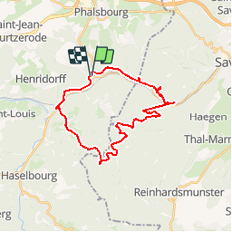
![](/images/other/stat-length.png)
![Randonnée V.T.T. Lutzelbourg - Autour de Lutzelbourg - Photo](https://media.geolcdn.com/t/1900/400/ext.pjpeg?maxdim=2&url=https%3A%2F%2Fservices.sitytrail.com%2FGeolivesWS%2FDownloadMedia.ashx%3FTrailID%3D105876%26Media%3D9855_2.jpg)
Autour de Lutzelbourg
tracegps
Utilisateur
![Longueur](/images/other/stat-length.png)
![Altitude max](https://static1.geolcdn.com/siteimages/upload/files/1508320355ic_sort_altitude_max_24dp.png)
![Dénivelé positif](https://static1.geolcdn.com/siteimages/upload/files/1508320355ic_sort_den_pos_24dp.png)
![Km-Effort](/images/other/stat-length.png)
![Altitude min](https://static1.geolcdn.com/siteimages/upload/files/1508320355ic_sort_altitude_min_24dp.png)
![Dénivelé négatif](https://static1.geolcdn.com/siteimages/upload/files/1508320355ic_sort_den_neg_24dp.png)
![Boucle](https://static1.geolcdn.com/siteimages/upload/files/16400158638029165_repeat_loop_refresh_sync_direction_icon.png)
![V.T.T.](https://static1.geolcdn.com/sitytour/trail-icons/202.png)
2h30
Difficulté : Moyen
![Scannez ce code QR pour ouvrir la randonnée dans l'application SityTrail](https://capi.geolives.com/qq0zvz2zws4bq2lad0pu/sitytour/trails/105876/qr.png?size=200)
Application GPS de randonnée GRATUITE
À propos
Randonnée V.T.T. de 26 km à découvrir à Grand Est, Moselle, Lutzelbourg. Cette randonnée est proposée par tracegps.
Description
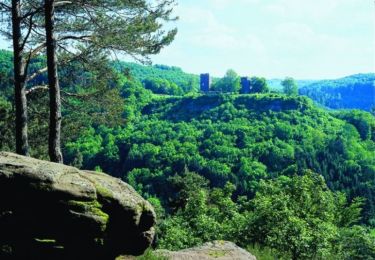
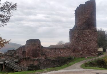
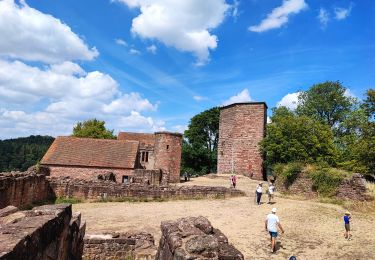
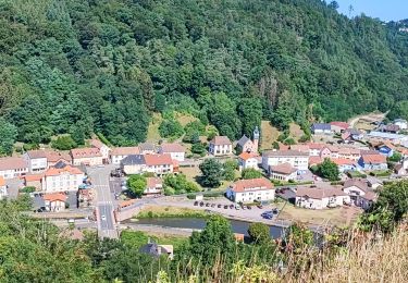
Départ à l'écluse au milieu du village, partir vers l'ouest le long du canal (pas en direction de Saverne) pour rejoindre le camping. En face de l'entrée du camping, il y a un sentier balisé "rond/cercle rouge", c'est une belle montée qui mène à Garrebourg. Il faudra éventuellement pousser le vtt car la montée est raide. A la sortie du village, on emprunte la route forestière de Kreuzkopf balisé rond rouge. Arrivé à un carrefour avec des bancs et tables, prendre à droite puis le premier sentier à gauche et suivre les "triangles bleus" en direction de la grotte des francs tireurs. Petite descente ludique, attention il y a une petite série de marche. Ensuite on remonte via un faux-plat montant jusqu'à un ancien village gallo-romain. On redescend ensuite vers le canal. Descente très rapide sur une route goudronnée. On rejoint tranquillement Lutzelbourg. Pour les plus fatigués, au niveau de l'écluse 25, la trace monte et longe le canal, on peut rejoindre Lutzelbourg par le canal.
Localisation
Commentaires
Randonnées à proximité
![Randonnée Marche Lutzelbourg - Lutzelbourg - Hultehouse - Wasserwald - Photo](https://media.geolcdn.com/t/375/260/ext.jpg?maxdim=2&url=https%3A%2F%2Fservices.sitytrail.com%2FGeolivesWS%2FDownloadMedia.ashx%3FTrailID%3D214384%26Media%3Dfix__20130818111405.jpg)
![Marche Marche](https://static1.geolcdn.com/sitytour/trail-icons/101.png)
Marche
![](/images/other/stat-length.png)
![](https://static1.geolcdn.com/siteimages/upload/files/16400158638029165_repeat_loop_refresh_sync_direction_icon.png)
![Randonnée V.T.T. Phalsbourg - Circuit VTT de Bonne Fontaine - Phalsbourg - Photo](https://media.geolcdn.com/t/375/260/ext.jpg?maxdim=2&url=https%3A%2F%2Fservices.sitytrail.com%2FGeolivesWS%2FDownloadMedia.ashx%3FTrailID%3D109090%26Media%3D3140_3.jpg)
![V.T.T. V.T.T.](https://static1.geolcdn.com/sitytour/trail-icons/202.png)
V.T.T.
![](/images/other/stat-length.png)
![](https://static1.geolcdn.com/siteimages/upload/files/16400158638029165_repeat_loop_refresh_sync_direction_icon.png)
![Randonnée Marche Phalsbourg - Circulaire de Phalsbourg - Lutzelbourg - Photo](https://media.geolcdn.com/t/375/260/ext.jpg?maxdim=2&url=https%3A%2F%2Fservices.sitytrail.com%2FGeolivesWS%2FDownloadMedia.ashx%3FTrailID%3D109079%26Media%3D3113_4.jpg)
![Marche Marche](https://static1.geolcdn.com/sitytour/trail-icons/101.png)
Marche
![](/images/other/stat-length.png)
![](https://static1.geolcdn.com/siteimages/upload/files/16400158638029165_repeat_loop_refresh_sync_direction_icon.png)
![Randonnée Marche Lutzelbourg - 2019-11-11 Marche Lutzelbourg Sentier des bornes - Photo](https://media.geolcdn.com/t/375/260/70b60def-8c43-43cf-a03a-6def50b8bb98.jpg&format=jpg&maxdim=2)
![Marche Marche](https://static1.geolcdn.com/sitytour/trail-icons/101.png)
Marche
![](/images/other/stat-length.png)
![](https://static1.geolcdn.com/siteimages/upload/files/16400158638029165_repeat_loop_refresh_sync_direction_icon.png)
![Randonnée Marche Lutzelbourg - Lutzelbourg Gobain 2015 - Photo](https://media.geolcdn.com/t/375/260/ext.jpg?maxdim=2&url=https%3A%2F%2Fstatic1.geolcdn.com%2Fsiteimages%2Fupload%2Ffiles%2F1553511878bg_sport_marche.png)
![Marche Marche](https://static1.geolcdn.com/sitytour/trail-icons/101.png)
Marche
![](/images/other/stat-length.png)
![](https://static1.geolcdn.com/siteimages/upload/files/16400158638029165_repeat_loop_refresh_sync_direction_icon.png)
![Randonnée Marche Henridorff - lutzbourg - Photo](https://media.geolcdn.com/t/375/260/d757a4dc-cc10-4039-a124-0382b7aea341.jpg&format=jpg&maxdim=2)
![Marche Marche](https://static1.geolcdn.com/sitytour/trail-icons/101.png)
![Randonnée Marche Henridorff - lutzelbourg - Photo](https://media.geolcdn.com/t/375/260/078fe525-181c-4e69-8634-4f1b64d735d1.jpg&format=jpg&maxdim=2)
![Marche Marche](https://static1.geolcdn.com/sitytour/trail-icons/101.png)
![Randonnée Randonnée équestre Danne-et-Quatre-Vents - Boucle Grotte Saint Vit Saverne - Photo](https://media.geolcdn.com/t/375/260/b2b809a2-74a3-44a6-b59c-8f490bbe9266.jpg&format=jpg&maxdim=2)
![Randonnée équestre Randonnée équestre](https://static1.geolcdn.com/sitytour/trail-icons/301.png)
Randonnée équestre
![](/images/other/stat-length.png)
![](https://static1.geolcdn.com/siteimages/upload/files/16400158638029165_repeat_loop_refresh_sync_direction_icon.png)
![Randonnée V.T.T. Lutzelbourg - 20150823 - Photo](https://media.geolcdn.com/t/375/260/ext.jpg?maxdim=2&url=https%3A%2F%2Fservices.sitytrail.com%2FGeolivesWS%2FDownloadMedia.ashx%3FTrailID%3D462876%26Media%3Dfix__20150823125004.jpg)
![V.T.T. V.T.T.](https://static1.geolcdn.com/sitytour/trail-icons/202.png)