![](/images/other/stat-length.png)
![Randonnée V.T.T. Fermanville - Fermanville - Le Vast - Photo](https://media.geolcdn.com/t/1900/400/ext.pjpeg?maxdim=2&url=https%3A%2F%2Fservices.sitytrail.com%2FGeolivesWS%2FDownloadMedia.ashx%3FTrailID%3D105842%26Media%3D9808_1.jpg)
Fermanville - Le Vast
tracegps
Utilisateur
![Longueur](/images/other/stat-length.png)
Longueur
32 km
![Altitude max](https://static1.geolcdn.com/siteimages/upload/files/1508320355ic_sort_altitude_max_24dp.png)
Altitude max
139 m
![Dénivelé positif](https://static1.geolcdn.com/siteimages/upload/files/1508320355ic_sort_den_pos_24dp.png)
Dénivelé positif
413 m
![Km-Effort](/images/other/stat-length.png)
Km-Effort
37 km
![Altitude min](https://static1.geolcdn.com/siteimages/upload/files/1508320355ic_sort_altitude_min_24dp.png)
Altitude min
2 m
![Dénivelé négatif](https://static1.geolcdn.com/siteimages/upload/files/1508320355ic_sort_den_neg_24dp.png)
Dénivelé négatif
443 m
![Boucle](https://static1.geolcdn.com/siteimages/upload/files/16400158638029165_repeat_loop_refresh_sync_direction_icon.png)
Boucle
Non
Date de création :
2014-12-10 00:00:00.0
Dernière modification :
2014-12-10 00:00:00.0
![V.T.T.](https://static1.geolcdn.com/sitytour/trail-icons/202.png)
2h30
Difficulté : Difficile
![Scannez ce code QR pour ouvrir la randonnée dans l'application SityTrail](https://capi.geolives.com/qq0zvz2zws4bq2lad0pu/sitytour/trails/105842/qr.png?size=200)
Application GPS de randonnée GRATUITE
À propos
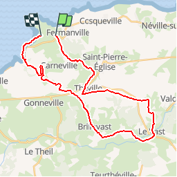
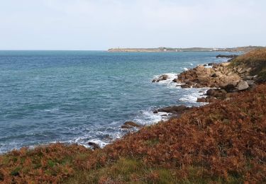
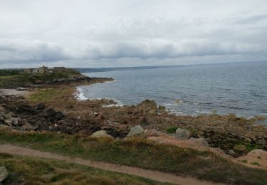
Randonnée V.T.T. de 32 km à découvrir à Normandie, Manche, Fermanville. Cette randonnée est proposée par tracegps.
Description
De Fermanville jusqu'à la vallée de la Saire à Le Vast. Une dernière descente dans un bois pour nous ramener au niveau de la mer. Très technique mais de toute beauté et pour finir 2km en front de mer, magnifique!
Localisation
Pays :
France
Région :
Normandie
Département/Province :
Manche
Commune :
Fermanville
Localité :
Unknown
Départ:(Dec)
Départ:(UTM)
611577 ; 5504710 (30U) N.
Commentaires
Randonnées à proximité
![Randonnée Marche Fermanville - La Vallée des Moulins - Photo](https://media.geolcdn.com/t/375/260/c70b4e51-995e-4d7a-bf0b-a8ccbeea7f50.jpg&format=jpg&maxdim=2)
![Marche Marche](https://static1.geolcdn.com/sitytour/trail-icons/101.png)
La Vallée des Moulins
Marche
Moyen
Fermanville,
Normandie,
Manche,
France
![](/images/other/stat-length.png)
9,1 km | 11 km-effort
2h 30min
![](https://static1.geolcdn.com/siteimages/upload/files/16400158638029165_repeat_loop_refresh_sync_direction_icon.png)
Oui
![Randonnée Marche Fermanville - Fermanville - Photo](https://media.geolcdn.com/t/375/260/3f291961-9aaf-4ea1-a127-c889045f6865.jpg&format=jpg&maxdim=2)
![Marche Marche](https://static1.geolcdn.com/sitytour/trail-icons/101.png)
![Randonnée Marche Fermanville - Fermanville / Maupertus - Photo](https://media.geolcdn.com/t/375/260/260bea8b-c2a4-4fce-9632-c73c3b6e2ace.jpeg&format=jpg&maxdim=2)
![Marche Marche](https://static1.geolcdn.com/sitytour/trail-icons/101.png)
Fermanville / Maupertus
Marche
Moyen
Fermanville,
Normandie,
Manche,
France
![](/images/other/stat-length.png)
21 km | 26 km-effort
3h 36min
![](https://static1.geolcdn.com/siteimages/upload/files/16400158638029165_repeat_loop_refresh_sync_direction_icon.png)
Oui
![Randonnée Marche Fermanville - 50 Autour du Cap LEVI 5km - Photo](https://media.geolcdn.com/t/375/260/45b22b03-bec5-41a2-a7f6-e496526d73d7.jpg&format=jpg&maxdim=2)
![Marche Marche](https://static1.geolcdn.com/sitytour/trail-icons/101.png)
50 Autour du Cap LEVI 5km
Marche
Très facile
Fermanville,
Normandie,
Manche,
France
![](/images/other/stat-length.png)
5,1 km | 5,6 km-effort
1h 22min
![](https://static1.geolcdn.com/siteimages/upload/files/16400158638029165_repeat_loop_refresh_sync_direction_icon.png)
Oui
![Randonnée Marche Fermanville - cap levi - Photo](https://media.geolcdn.com/t/375/260/ext.jpg?maxdim=2&url=https%3A%2F%2Fstatic1.geolcdn.com%2Fsiteimages%2Fupload%2Ffiles%2F1553511878bg_sport_marche.png)
![Marche Marche](https://static1.geolcdn.com/sitytour/trail-icons/101.png)
cap levi
Marche
Facile
(1)
Fermanville,
Normandie,
Manche,
France
![](/images/other/stat-length.png)
4,4 km | 4,8 km-effort
1h 3min
![](https://static1.geolcdn.com/siteimages/upload/files/16400158638029165_repeat_loop_refresh_sync_direction_icon.png)
Oui
![Randonnée Marche Fermanville - fermanville 12042019 - Photo](https://media.geolcdn.com/t/375/260/ext.jpg?maxdim=2&url=https%3A%2F%2Fstatic1.geolcdn.com%2Fsiteimages%2Fupload%2Ffiles%2F1553511878bg_sport_marche.png)
![Marche Marche](https://static1.geolcdn.com/sitytour/trail-icons/101.png)
fermanville 12042019
Marche
Très facile
(1)
Fermanville,
Normandie,
Manche,
France
![](/images/other/stat-length.png)
9,3 km | 11,8 km-effort
2h 4min
![](https://static1.geolcdn.com/siteimages/upload/files/16400158638029165_repeat_loop_refresh_sync_direction_icon.png)
Oui
![Randonnée Marche Fermanville - boucle cap Lévy plage mondree - Photo](https://media.geolcdn.com/t/375/260/ext.jpg?maxdim=2&url=https%3A%2F%2Fstatic1.geolcdn.com%2Fsiteimages%2Fupload%2Ffiles%2F1553511878bg_sport_marche.png)
![Marche Marche](https://static1.geolcdn.com/sitytour/trail-icons/101.png)
boucle cap Lévy plage mondree
Marche
Très facile
(1)
Fermanville,
Normandie,
Manche,
France
![](/images/other/stat-length.png)
7 km | 8 km-effort
1h 48min
![](https://static1.geolcdn.com/siteimages/upload/files/16400158638029165_repeat_loop_refresh_sync_direction_icon.png)
Oui
![Randonnée V.T.T. Théville - Petite balade dans le val de Saire - Théville - Photo](https://media.geolcdn.com/t/375/260/ext.jpg?maxdim=2&url=https%3A%2F%2Fservices.sitytrail.com%2FGeolivesWS%2FDownloadMedia.ashx%3FTrailID%3D215112%26Media%3D15697_2.jpg)
![V.T.T. V.T.T.](https://static1.geolcdn.com/sitytour/trail-icons/202.png)
Petite balade dans le val de Saire - Théville
V.T.T.
Moyen
Théville,
Normandie,
Manche,
France
![](/images/other/stat-length.png)
31 km | 37 km-effort
4h 49min
![](https://static1.geolcdn.com/siteimages/upload/files/16400158638029165_repeat_loop_refresh_sync_direction_icon.png)
Oui
![Randonnée Marche Maupertus-sur-Mer - Anse du Brick ET Les Landes - Photo](https://media.geolcdn.com/t/375/260/ext.jpg?maxdim=2&url=https%3A%2F%2Fstatic1.geolcdn.com%2Fsiteimages%2Fupload%2Ffiles%2F1553511878bg_sport_marche.png)
![Marche Marche](https://static1.geolcdn.com/sitytour/trail-icons/101.png)
Anse du Brick ET Les Landes
Marche
Moyen
Maupertus-sur-Mer,
Normandie,
Manche,
France
![](/images/other/stat-length.png)
14 km | 18 km-effort
3h 56min
![](https://static1.geolcdn.com/siteimages/upload/files/16400158638029165_repeat_loop_refresh_sync_direction_icon.png)
Oui