![](/images/other/stat-length.png)
![Randonnée Marche Lavalette - Les perdrix - Alairac - Photo](https://media.geolcdn.com/t/1900/400/ext.pjpeg?maxdim=2&url=https%3A%2F%2Fservices.sitytrail.com%2FGeolivesWS%2FDownloadMedia.ashx%3FTrailID%3D105777%26Media%3D9675_5.jpg)
Les perdrix - Alairac
tracegps
Utilisateur
![Longueur](/images/other/stat-length.png)
Longueur
11,1 km
![Altitude max](https://static1.geolcdn.com/siteimages/upload/files/1508320355ic_sort_altitude_max_24dp.png)
Altitude max
317 m
![Dénivelé positif](https://static1.geolcdn.com/siteimages/upload/files/1508320355ic_sort_den_pos_24dp.png)
Dénivelé positif
219 m
![Km-Effort](/images/other/stat-length.png)
Km-Effort
14 km
![Altitude min](https://static1.geolcdn.com/siteimages/upload/files/1508320355ic_sort_altitude_min_24dp.png)
Altitude min
163 m
![Dénivelé négatif](https://static1.geolcdn.com/siteimages/upload/files/1508320355ic_sort_den_neg_24dp.png)
Dénivelé négatif
214 m
![Boucle](https://static1.geolcdn.com/siteimages/upload/files/16400158638029165_repeat_loop_refresh_sync_direction_icon.png)
Boucle
Oui
Date de création :
2014-12-10 00:00:00.0
Dernière modification :
2014-12-10 00:00:00.0
![Marche](https://static1.geolcdn.com/sitytour/trail-icons/101.png)
3h00
Difficulté : Facile
![Scannez ce code QR pour ouvrir la randonnée dans l'application SityTrail](https://capi.geolives.com/qq0zvz2zws4bq2lad0pu/sitytour/trails/105777/qr.png?size=200)
Application GPS de randonnée GRATUITE
À propos
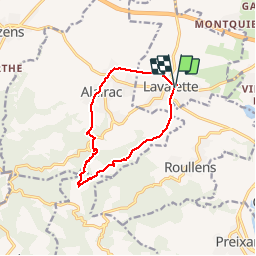
Randonnée Marche de 11,1 km à découvrir à Occitanie, Aude, Lavalette. Cette randonnée est proposée par tracegps.
Description
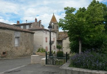
Départ devant le foyer municipal d'Alairac. Parcourir au départ ou à l'arrivée, la circulade d'Alairac. (pas enregistrée dans le fichier gpx)
Localisation
Pays :
France
Région :
Occitanie
Département/Province :
Aude
Commune :
Lavalette
Localité :
Unknown
Départ:(Dec)
Départ:(UTM)
440456 ; 4781601 (31T) N.
Commentaires
Randonnées à proximité
![Randonnée Marche Preixan - preixan - Photo](https://media.geolcdn.com/t/375/260/ext.jpg?maxdim=2&url=https%3A%2F%2Fstatic1.geolcdn.com%2Fsiteimages%2Fupload%2Ffiles%2F1553511878bg_sport_marche.png)
![Marche Marche](https://static1.geolcdn.com/sitytour/trail-icons/101.png)
preixan
Marche
Très facile
(1)
Preixan,
Occitanie,
Aude,
France
![](/images/other/stat-length.png)
9,1 km | 12,1 km-effort
2h 42min
![](https://static1.geolcdn.com/siteimages/upload/files/16400158638029165_repeat_loop_refresh_sync_direction_icon.png)
Oui
![Randonnée Marche Leuc - Leuc_les-justices VM - Photo](https://media.geolcdn.com/t/375/260/ext.jpg?maxdim=2&url=https%3A%2F%2Fstatic1.geolcdn.com%2Fsiteimages%2Fupload%2Ffiles%2F1553511878bg_sport_marche.png)
![Marche Marche](https://static1.geolcdn.com/sitytour/trail-icons/101.png)
Leuc_les-justices VM
Marche
Moyen
(1)
Leuc,
Occitanie,
Aude,
France
![](/images/other/stat-length.png)
6,2 km | 8,5 km-effort
1h 55min
![](https://static1.geolcdn.com/siteimages/upload/files/16400158638029165_repeat_loop_refresh_sync_direction_icon.png)
Oui
![Randonnée Marche Roullens - roullens-lac de taure 01 VM - Photo](https://media.geolcdn.com/t/375/260/ext.jpg?maxdim=2&url=https%3A%2F%2Fstatic1.geolcdn.com%2Fsiteimages%2Fupload%2Ffiles%2F1553511878bg_sport_marche.png)
![Marche Marche](https://static1.geolcdn.com/sitytour/trail-icons/101.png)
roullens-lac de taure 01 VM
Marche
Moyen
(1)
Roullens,
Occitanie,
Aude,
France
![](/images/other/stat-length.png)
7,5 km | 9,4 km-effort
2h 7min
![](https://static1.geolcdn.com/siteimages/upload/files/16400158638029165_repeat_loop_refresh_sync_direction_icon.png)
Oui
![Randonnée Marche Roullens - promenade du domaine fantôme - Photo](https://media.geolcdn.com/t/375/260/ext.jpg?maxdim=2&url=https%3A%2F%2Fservices.sitytrail.com%2FGeolivesWS%2FDownloadMedia.ashx%3FTrailID%3D735744%26Media%3Dfix__20170419112516.jpg)
![Marche Marche](https://static1.geolcdn.com/sitytour/trail-icons/101.png)
promenade du domaine fantôme
Marche
Très facile
Roullens,
Occitanie,
Aude,
France
![](/images/other/stat-length.png)
7,3 km | 9,2 km-effort
1h 57min
![](https://static1.geolcdn.com/siteimages/upload/files/16400158638029165_repeat_loop_refresh_sync_direction_icon.png)
Oui
![Randonnée Marche Roullens - promenade du domaine fantôme - Photo](https://media.geolcdn.com/t/375/260/ext.jpg?maxdim=2&url=https%3A%2F%2Fservices.sitytrail.com%2FGeolivesWS%2FDownloadMedia.ashx%3FTrailID%3D735742%26Media%3Dfix__20170419112516.jpg)
![Marche Marche](https://static1.geolcdn.com/sitytour/trail-icons/101.png)
promenade du domaine fantôme
Marche
Très facile
Roullens,
Occitanie,
Aude,
France
![](/images/other/stat-length.png)
7,3 km | 9,2 km-effort
1h 57min
![](https://static1.geolcdn.com/siteimages/upload/files/16400158638029165_repeat_loop_refresh_sync_direction_icon.png)
Oui
![Randonnée Marche Arzens - Chemin du Piémont Pyrénéen - Arzens à Fanjeaux - Photo](https://media.geolcdn.com/t/375/260/ext.jpg?maxdim=2&url=https%3A%2F%2Fservices.sitytrail.com%2FGeolivesWS%2FDownloadMedia.ashx%3FTrailID%3D106399%26Media%3D10885_3.jpg)
![Marche Marche](https://static1.geolcdn.com/sitytour/trail-icons/101.png)
Chemin du Piémont Pyrénéen - Arzens à Fanjeaux
Marche
Difficile
Arzens,
Occitanie,
Aude,
France
![](/images/other/stat-length.png)
18,7 km | 24 km-effort
6h 0min
![](https://static1.geolcdn.com/siteimages/upload/files/16400158638029165_repeat_loop_refresh_sync_direction_icon.png)
Non
![Randonnée Marche Leuc - Le Leuc - Photo](https://media.geolcdn.com/t/375/260/ext.jpg?maxdim=2&url=https%3A%2F%2Fservices.sitytrail.com%2FGeolivesWS%2FDownloadMedia.ashx%3FTrailID%3D104484%26Media%3D7804_4.jpg)
![Marche Marche](https://static1.geolcdn.com/sitytour/trail-icons/101.png)
![Randonnée V.T.T. Couffoulens - Couffoulens Verzeille Leuc - Photo](https://media.geolcdn.com/t/375/260/ext.jpg?maxdim=2&url=https%3A%2F%2Fservices.sitytrail.com%2FGeolivesWS%2FDownloadMedia.ashx%3FTrailID%3D751977%26Media%3Dfix__20170513114347.jpg)
![V.T.T. V.T.T.](https://static1.geolcdn.com/sitytour/trail-icons/202.png)
Couffoulens Verzeille Leuc
V.T.T.
Facile
Couffoulens,
Occitanie,
Aude,
France
![](/images/other/stat-length.png)
14 km | 17,5 km-effort
1h 0min
![](https://static1.geolcdn.com/siteimages/upload/files/16400158638029165_repeat_loop_refresh_sync_direction_icon.png)
Oui
![Randonnée Marche Preixan - PREIXAN : Dans les vignes et les champs - Photo](https://media.geolcdn.com/t/375/260/ext.jpg?maxdim=2&url=https%3A%2F%2Fstatic1.geolcdn.com%2Fsiteimages%2Fupload%2Ffiles%2F1553511878bg_sport_marche.png)
![Marche Marche](https://static1.geolcdn.com/sitytour/trail-icons/101.png)
PREIXAN : Dans les vignes et les champs
Marche
Moyen
Preixan,
Occitanie,
Aude,
France
![](/images/other/stat-length.png)
8,4 km | 11,7 km-effort
2h 39min
![](https://static1.geolcdn.com/siteimages/upload/files/16400158638029165_repeat_loop_refresh_sync_direction_icon.png)
Oui
chaud