![](/images/other/stat-length.png)
![Randonnée Marche Bazoches - Autour de Vauban - Bazoches - Photo](https://media.geolcdn.com/t/1900/400/ext.pjpeg?maxdim=2&url=https%3A%2F%2Fservices.sitytrail.com%2FGeolivesWS%2FDownloadMedia.ashx%3FTrailID%3D105713%26Media%3D9558_2.jpg)
Autour de Vauban - Bazoches
tracegps
Utilisateur
![Longueur](/images/other/stat-length.png)
Longueur
11,1 km
![Altitude max](https://static1.geolcdn.com/siteimages/upload/files/1508320355ic_sort_altitude_max_24dp.png)
Altitude max
417 m
![Dénivelé positif](https://static1.geolcdn.com/siteimages/upload/files/1508320355ic_sort_den_pos_24dp.png)
Dénivelé positif
332 m
![Km-Effort](/images/other/stat-length.png)
Km-Effort
15,5 km
![Altitude min](https://static1.geolcdn.com/siteimages/upload/files/1508320355ic_sort_altitude_min_24dp.png)
Altitude min
211 m
![Dénivelé négatif](https://static1.geolcdn.com/siteimages/upload/files/1508320355ic_sort_den_neg_24dp.png)
Dénivelé négatif
334 m
![Boucle](https://static1.geolcdn.com/siteimages/upload/files/16400158638029165_repeat_loop_refresh_sync_direction_icon.png)
Boucle
Oui
Date de création :
2014-12-10 00:00:00.0
Dernière modification :
2014-12-10 00:00:00.0
![Marche](https://static1.geolcdn.com/sitytour/trail-icons/101.png)
3h10
Difficulté : Moyen
![Scannez ce code QR pour ouvrir la randonnée dans l'application SityTrail](https://capi.geolives.com/qq0zvz2zws4bq2lad0pu/sitytour/trails/105713/qr.png?size=200)
Application GPS de randonnée GRATUITE
À propos
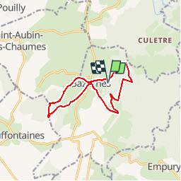
Randonnée Marche de 11,1 km à découvrir à Bourgogne-Franche-Comté, Nièvre, Bazoches. Cette randonnée est proposée par tracegps.
Description
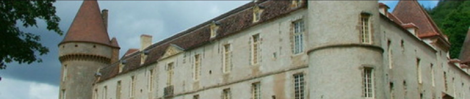
Découverte du Château de Bazoches (où Vauban avait son bureau d'études) et de sa campagne environnante.
Localisation
Pays :
France
Région :
Bourgogne-Franche-Comté
Département/Province :
Nièvre
Commune :
Bazoches
Localité :
Unknown
Départ:(Dec)
Départ:(UTM)
559936 ; 5247487 (31T) N.
Commentaires
Randonnées à proximité
![Randonnée Marche Saint-André-en-Morvan - SAINT-ANDRE-EN-MORVAN (9/20) - Photo](https://media.geolcdn.com/t/375/260/2afd1577-a731-4de7-8e6f-0fb7b3dcf911.jpg&format=jpg&maxdim=2)
![Marche Marche](https://static1.geolcdn.com/sitytour/trail-icons/101.png)
SAINT-ANDRE-EN-MORVAN (9/20)
Marche
Moyen
Saint-André-en-Morvan,
Bourgogne-Franche-Comté,
Nièvre,
France
![](/images/other/stat-length.png)
8,9 km | 11,8 km-effort
3h 15min
![](https://static1.geolcdn.com/siteimages/upload/files/16400158638029165_repeat_loop_refresh_sync_direction_icon.png)
Oui
![Randonnée Marche Bazoches - BAZOCHES - (9/20) - Photo](https://media.geolcdn.com/t/375/260/311c8b98-292f-4397-a886-c9a8ef5e96fd.jpg&format=jpg&maxdim=2)
![Marche Marche](https://static1.geolcdn.com/sitytour/trail-icons/101.png)
BAZOCHES - (9/20)
Marche
Moyen
Bazoches,
Bourgogne-Franche-Comté,
Nièvre,
France
![](/images/other/stat-length.png)
10,7 km | 15 km-effort
3h 43min
![](https://static1.geolcdn.com/siteimages/upload/files/16400158638029165_repeat_loop_refresh_sync_direction_icon.png)
Oui
![Randonnée Cheval Bazoches - bazoches - chateau de Vauban - Photo](https://media.geolcdn.com/t/375/260/ext.jpg?maxdim=2&url=https%3A%2F%2Fstatic1.geolcdn.com%2Fsiteimages%2Fupload%2Ffiles%2F1524743154cheval.jpg)
![Cheval Cheval](https://static1.geolcdn.com/sitytour/trail-icons/300.png)
bazoches - chateau de Vauban
Cheval
Très facile
Bazoches,
Bourgogne-Franche-Comté,
Nièvre,
France
![](/images/other/stat-length.png)
12,7 km | 17,5 km-effort
Inconnu
![](https://static1.geolcdn.com/siteimages/upload/files/16400158638029165_repeat_loop_refresh_sync_direction_icon.png)
Oui
![Randonnée Vélo de route Bazoches - champign-brassy-chalaux - Photo](https://media.geolcdn.com/t/375/260/2bcbfe87-c01d-4d50-a383-6ca3bbe4fa3c.jpg&format=jpg&maxdim=2)
![Vélo de route Vélo de route](https://static1.geolcdn.com/sitytour/trail-icons/201.png)
champign-brassy-chalaux
Vélo de route
Difficile
Bazoches,
Bourgogne-Franche-Comté,
Nièvre,
France
![](/images/other/stat-length.png)
50 km | 64 km-effort
2h 53min
![](https://static1.geolcdn.com/siteimages/upload/files/16400158638029165_repeat_loop_refresh_sync_direction_icon.png)
Oui
![Randonnée Marche Bazoches - Compestelle etape 2 - Photo](https://media.geolcdn.com/t/375/260/ext.jpg?maxdim=2&url=https%3A%2F%2Fstatic1.geolcdn.com%2Fsiteimages%2Fupload%2Ffiles%2F1553511878bg_sport_marche.png)
![Marche Marche](https://static1.geolcdn.com/sitytour/trail-icons/101.png)
Compestelle etape 2
Marche
Moyen
Bazoches,
Bourgogne-Franche-Comté,
Nièvre,
France
![](/images/other/stat-length.png)
22 km | 28 km-effort
6h 6min
![](https://static1.geolcdn.com/siteimages/upload/files/16400158638029165_repeat_loop_refresh_sync_direction_icon.png)
Non
![Randonnée A pied Saint-André-en-Morvan - Morvan jour 4: Saint-André en Morvan à le Vieux Dun - Photo](https://media.geolcdn.com/t/375/260/ext.jpg?maxdim=2&url=https%3A%2F%2Fstatic1.geolcdn.com%2Fsiteimages%2Fupload%2Ffiles%2F1545311037marcheuse_200dpi.jpg)
![A pied A pied](https://static1.geolcdn.com/sitytour/trail-icons/100.png)
Morvan jour 4: Saint-André en Morvan à le Vieux Dun
A pied
Difficile
Saint-André-en-Morvan,
Bourgogne-Franche-Comté,
Nièvre,
France
![](/images/other/stat-length.png)
22 km | 32 km-effort
7h 11min
![](https://static1.geolcdn.com/siteimages/upload/files/16400158638029165_repeat_loop_refresh_sync_direction_icon.png)
Non
![Randonnée Randonnée équestre Bazoches - chateau de Vauban - Photo](https://media.geolcdn.com/t/375/260/ext.jpg?maxdim=2&url=https%3A%2F%2Fstatic1.geolcdn.com%2Fsiteimages%2Fupload%2Ffiles%2F1524743154cheval.jpg)
![Randonnée équestre Randonnée équestre](https://static1.geolcdn.com/sitytour/trail-icons/301.png)
chateau de Vauban
Randonnée équestre
Facile
Bazoches,
Bourgogne-Franche-Comté,
Nièvre,
France
![](/images/other/stat-length.png)
12,7 km | 17,6 km-effort
1h 42min
![](https://static1.geolcdn.com/siteimages/upload/files/16400158638029165_repeat_loop_refresh_sync_direction_icon.png)
Oui
![Randonnée Marche Saint-André-en-Morvan - Saint André en Morvan - Photo](https://media.geolcdn.com/t/375/260/ext.jpg?maxdim=2&url=https%3A%2F%2Fstatic1.geolcdn.com%2Fsiteimages%2Fupload%2Ffiles%2F1553511878bg_sport_marche.png)
![Marche Marche](https://static1.geolcdn.com/sitytour/trail-icons/101.png)
Saint André en Morvan
Marche
Difficile
Saint-André-en-Morvan,
Bourgogne-Franche-Comté,
Nièvre,
France
![](/images/other/stat-length.png)
10,9 km | 14,9 km-effort
3h 0min
![](https://static1.geolcdn.com/siteimages/upload/files/16400158638029165_repeat_loop_refresh_sync_direction_icon.png)
Oui
![Randonnée Marche Bazoches - vezelais 3 - Photo](https://media.geolcdn.com/t/375/260/ext.jpg?maxdim=2&url=https%3A%2F%2Fstatic1.geolcdn.com%2Fsiteimages%2Fupload%2Ffiles%2F1553511878bg_sport_marche.png)
![Marche Marche](https://static1.geolcdn.com/sitytour/trail-icons/101.png)
vezelais 3
Marche
Très difficile
Bazoches,
Bourgogne-Franche-Comté,
Nièvre,
France
![](/images/other/stat-length.png)
16,1 km | 20 km-effort
6h 26min
![](https://static1.geolcdn.com/siteimages/upload/files/16400158638029165_repeat_loop_refresh_sync_direction_icon.png)
Non
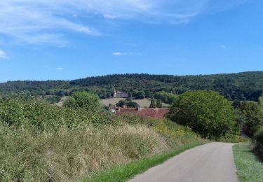
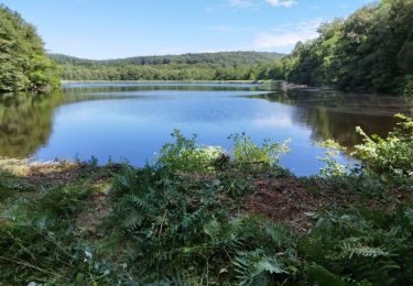
Paysages variés. Nombreux points de vue.