![](/images/other/stat-length.png)
![Randonnée Autre activité Écromagny - Circuit les Epoissets - Photo](https://media.geolcdn.com/t/1900/400/ext.pjpeg?maxdim=2&url=https%3A%2F%2Fstatic1.geolcdn.com%2Fsiteimages%2Fupload%2Ffiles%2F1545311037marcheuse_200dpi.jpg)
Circuit les Epoissets
margotte
Utilisateur
![Longueur](/images/other/stat-length.png)
![Altitude max](https://static1.geolcdn.com/siteimages/upload/files/1508320355ic_sort_altitude_max_24dp.png)
![Dénivelé positif](https://static1.geolcdn.com/siteimages/upload/files/1508320355ic_sort_den_pos_24dp.png)
![Km-Effort](/images/other/stat-length.png)
![Altitude min](https://static1.geolcdn.com/siteimages/upload/files/1508320355ic_sort_altitude_min_24dp.png)
![Dénivelé négatif](https://static1.geolcdn.com/siteimages/upload/files/1508320355ic_sort_den_neg_24dp.png)
![Boucle](https://static1.geolcdn.com/siteimages/upload/files/16400158638029165_repeat_loop_refresh_sync_direction_icon.png)
![Autre activité](https://static1.geolcdn.com/sitytour/trail-icons/900.png)
--
Difficulté : Inconnu
![Scannez ce code QR pour ouvrir la randonnée dans l'application SityTrail](https://capi.geolives.com/qq0zvz2zws4bq2lad0pu/sitytour/trails/1056538/qr.png?size=200)
Application GPS de randonnée GRATUITE
À propos
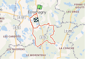
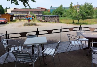
Randonnée Autre activité de 7,8 km à découvrir à Bourgogne-Franche-Comté, Haute-Saône, Écromagny. Cette randonnée est proposée par margotte.
Description
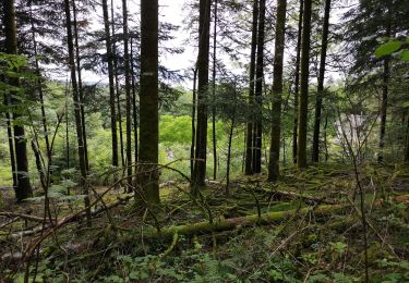
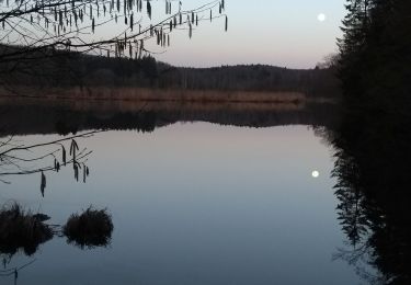
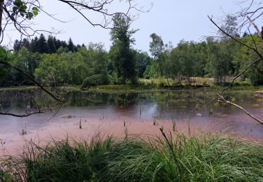
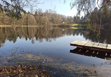
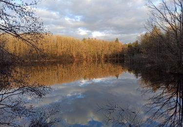
Au cœur du plateau des 1000 Étangs, ce circuit familial vous emmène à la découverte de ces paysages de landes et de tourbières si caractéristique de ce milieu. Au départ du village, observez la tourbière des Viaux, véritable arche de Noé végétale puis, laissez-vous guider par les panneaux d'information disposés sur le parcours.
Localisation
Commentaires
Randonnées à proximité
![Randonnée Marche Écromagny - Milles Étangs 18.06.2020 - Photo](https://media.geolcdn.com/t/375/260/bf565706-8d63-40d1-ae7b-2fe3d9e04a9b.jpg&format=jpg&maxdim=2)
![Marche Marche](https://static1.geolcdn.com/sitytour/trail-icons/101.png)
Marche
![](/images/other/stat-length.png)
![](https://static1.geolcdn.com/siteimages/upload/files/16400158638029165_repeat_loop_refresh_sync_direction_icon.png)
![Randonnée Marche Faucogney-et-la-Mer - 08-02-20 La mer, étang de Pierre Plate et retour. - Photo](https://media.geolcdn.com/t/375/260/1db8c6b9-2ea1-4f8e-aef5-d4d9373f14e8.jpg&format=jpg&maxdim=2)
![Marche Marche](https://static1.geolcdn.com/sitytour/trail-icons/101.png)
Marche
![](/images/other/stat-length.png)
![](https://static1.geolcdn.com/siteimages/upload/files/16400158638029165_repeat_loop_refresh_sync_direction_icon.png)
![Randonnée V.T.T. Mélisey - 1000 2tangs 54km 935ml - Photo](https://media.geolcdn.com/t/375/260/ext.jpg?maxdim=2&url=https%3A%2F%2Fstatic1.geolcdn.com%2Fsiteimages%2Fupload%2Ffiles%2F1524743154velo.jpg)
![V.T.T. V.T.T.](https://static1.geolcdn.com/sitytour/trail-icons/202.png)
V.T.T.
![](/images/other/stat-length.png)
![](https://static1.geolcdn.com/siteimages/upload/files/16400158638029165_repeat_loop_refresh_sync_direction_icon.png)
![Randonnée Marche Écromagny - Étang de plate pierre - Photo](https://media.geolcdn.com/t/375/260/750a5518-1d11-451b-bbbc-0f0268ba730a.jpg&format=jpg&maxdim=2)
![Marche Marche](https://static1.geolcdn.com/sitytour/trail-icons/101.png)
Marche
![](/images/other/stat-length.png)
![](https://static1.geolcdn.com/siteimages/upload/files/16400158638029165_repeat_loop_refresh_sync_direction_icon.png)
![Randonnée Marche Écromagny - Ecromagny Rando réelle - Photo](https://media.geolcdn.com/t/375/260/2b0a0f79-95d7-465e-83b4-b1169e1c19ae.jpg&format=jpg&maxdim=2)
![Marche Marche](https://static1.geolcdn.com/sitytour/trail-icons/101.png)
Marche
![](/images/other/stat-length.png)
![](https://static1.geolcdn.com/siteimages/upload/files/16400158638029165_repeat_loop_refresh_sync_direction_icon.png)
![Randonnée Marche Belmont - 4-03-22 circuit du bois des hauts, Belmont - Photo](https://media.geolcdn.com/t/375/260/c685d17a-ab2b-45db-94e8-f03a20c0660c.jpg&format=jpg&maxdim=2)
![Marche Marche](https://static1.geolcdn.com/sitytour/trail-icons/101.png)
Marche
![](/images/other/stat-length.png)
![](https://static1.geolcdn.com/siteimages/upload/files/16400158638029165_repeat_loop_refresh_sync_direction_icon.png)
![Randonnée Marche Mélisey - melissey - Photo](https://media.geolcdn.com/t/375/260/5d917a29-e862-4707-9a23-b18515e6ef08.jpg&format=jpg&maxdim=2)
![Marche Marche](https://static1.geolcdn.com/sitytour/trail-icons/101.png)
Marche
![](/images/other/stat-length.png)
![](https://static1.geolcdn.com/siteimages/upload/files/16400158638029165_repeat_loop_refresh_sync_direction_icon.png)
![Randonnée Marche Faucogney-et-la-Mer - la mzr - Photo](https://media.geolcdn.com/t/375/260/4085d514-fed2-4f1a-a225-1e5c9d3a718a.jpg&format=jpg&maxdim=2)
![Marche Marche](https://static1.geolcdn.com/sitytour/trail-icons/101.png)
Marche
![](/images/other/stat-length.png)
![](https://static1.geolcdn.com/siteimages/upload/files/16400158638029165_repeat_loop_refresh_sync_direction_icon.png)
![Randonnée Marche Faucogney-et-la-Mer - 23-02-22 marche Oroz, étangs... - Photo](https://media.geolcdn.com/t/375/260/65fda660-2809-43eb-960c-29389fba8610.jpg&format=jpg&maxdim=2)
![Marche Marche](https://static1.geolcdn.com/sitytour/trail-icons/101.png)
Marche
![](/images/other/stat-length.png)
![](https://static1.geolcdn.com/siteimages/upload/files/16400158638029165_repeat_loop_refresh_sync_direction_icon.png)