![](/images/other/stat-length.png)
![Randonnée Marche Ploubazlanec - Circuit de la pointe de l'Arcouest - Ploubazlanec - Photo](https://media.geolcdn.com/t/1900/400/ext.pjpeg?maxdim=2&url=https%3A%2F%2Fservices.sitytrail.com%2FGeolivesWS%2FDownloadMedia.ashx%3FTrailID%3D105606%26Media%3D9374_6.jpg)
Circuit de la pointe de l'Arcouest - Ploubazlanec
tracegps
Utilisateur
![Longueur](/images/other/stat-length.png)
Longueur
5,8 km
![Altitude max](https://static1.geolcdn.com/siteimages/upload/files/1508320355ic_sort_altitude_max_24dp.png)
Altitude max
69 m
![Dénivelé positif](https://static1.geolcdn.com/siteimages/upload/files/1508320355ic_sort_den_pos_24dp.png)
Dénivelé positif
121 m
![Km-Effort](/images/other/stat-length.png)
Km-Effort
7,4 km
![Altitude min](https://static1.geolcdn.com/siteimages/upload/files/1508320355ic_sort_altitude_min_24dp.png)
Altitude min
0 m
![Dénivelé négatif](https://static1.geolcdn.com/siteimages/upload/files/1508320355ic_sort_den_neg_24dp.png)
Dénivelé négatif
122 m
![Boucle](https://static1.geolcdn.com/siteimages/upload/files/16400158638029165_repeat_loop_refresh_sync_direction_icon.png)
Boucle
Oui
Date de création :
2014-12-10 00:00:00.0
Dernière modification :
2014-12-10 00:00:00.0
![Marche](https://static1.geolcdn.com/sitytour/trail-icons/101.png)
1h30
Difficulté : Facile
![Scannez ce code QR pour ouvrir la randonnée dans l'application SityTrail](https://capi.geolives.com/qq0zvz2zws4bq2lad0pu/sitytour/trails/105606/qr.png?size=200)
Application GPS de randonnée GRATUITE
À propos
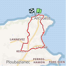
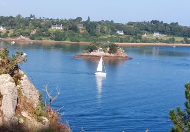
Randonnée Marche de 5,8 km à découvrir à Bretagne, Côtes-d'Armor, Ploubazlanec. Cette randonnée est proposée par tracegps.
Description
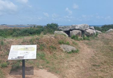
Circuit proposé par le Syndicat d'Initiative de Ploubazlanec . Départ du parking de la pointe de l’Arcouest. Retrouvez le circuit sur le dépliant du Syndicat d'Initiative.
Localisation
Pays :
France
Région :
Bretagne
Département/Province :
Côtes-d'Armor
Commune :
Ploubazlanec
Localité :
Unknown
Départ:(Dec)
Départ:(UTM)
498451 ; 5407533 (30U) N.
Commentaires
Randonnées à proximité
![Randonnée Marche Île-de-Bréhat - Bréhat : le tour de l'ile - Photo](https://media.geolcdn.com/t/375/260/ext.jpg?maxdim=2&url=https%3A%2F%2Fservices.sitytrail.com%2FGeolivesWS%2FDownloadMedia.ashx%3FTrailID%3D105477%26Media%3D9220_6.jpg)
![Marche Marche](https://static1.geolcdn.com/sitytour/trail-icons/101.png)
Bréhat : le tour de l'ile
Marche
Moyen
(6)
Île-de-Bréhat,
Bretagne,
Côtes-d'Armor,
France
![](/images/other/stat-length.png)
11,9 km | 13,8 km-effort
5h 0min
![](https://static1.geolcdn.com/siteimages/upload/files/16400158638029165_repeat_loop_refresh_sync_direction_icon.png)
Oui
![Randonnée Marche Paimpol - Paimpol - GR34 Port Lazo - 25.5km 400m 6h15 (45mn) - 2024 06 30 - Photo](https://media.geolcdn.com/t/375/260/a1e8d6e5-d31d-477d-9229-268ec1b6062a.jpg&format=jpg&maxdim=2)
![Marche Marche](https://static1.geolcdn.com/sitytour/trail-icons/101.png)
Paimpol - GR34 Port Lazo - 25.5km 400m 6h15 (45mn) - 2024 06 30
Marche
Difficile
Paimpol,
Bretagne,
Côtes-d'Armor,
France
![](/images/other/stat-length.png)
26 km | 31 km-effort
6h 15min
![](https://static1.geolcdn.com/siteimages/upload/files/16400158638029165_repeat_loop_refresh_sync_direction_icon.png)
Oui
![Randonnée Marche Ploubazlanec - Loguivy-de-la-Mer Mélus - GR34 Paimpol - 22.4km 375m 3h30 (45mn) - 2024 06 29 - Photo](https://media.geolcdn.com/t/375/260/448477d6-4d29-455f-a129-e2f273f0fc82.jpg&format=jpg&maxdim=2)
![Marche Marche](https://static1.geolcdn.com/sitytour/trail-icons/101.png)
Loguivy-de-la-Mer Mélus - GR34 Paimpol - 22.4km 375m 3h30 (45mn) - 2024 06 29
Marche
Moyen
Ploubazlanec,
Bretagne,
Côtes-d'Armor,
France
![](/images/other/stat-length.png)
22 km | 27 km-effort
5h 30min
![](https://static1.geolcdn.com/siteimages/upload/files/16400158638029165_repeat_loop_refresh_sync_direction_icon.png)
Oui
![Randonnée Marche Ploubazlanec - GR34-EtapeII-J04 - Photo](https://media.geolcdn.com/t/375/260/ext.jpg?maxdim=2&url=https%3A%2F%2Fstatic1.geolcdn.com%2Fsiteimages%2Fupload%2Ffiles%2F1553511878bg_sport_marche.png)
![Marche Marche](https://static1.geolcdn.com/sitytour/trail-icons/101.png)
GR34-EtapeII-J04
Marche
Moyen
(1)
Ploubazlanec,
Bretagne,
Côtes-d'Armor,
France
![](/images/other/stat-length.png)
23 km | 29 km-effort
8h 0min
![](https://static1.geolcdn.com/siteimages/upload/files/16400158638029165_repeat_loop_refresh_sync_direction_icon.png)
Non
![Randonnée Marche Pleubian - GR_34_DD_25_Pleubian_Kerbors_20240818 - Photo](https://media.geolcdn.com/t/375/260/2117f1e3-efa1-4275-bf33-99c4a5ec2a1b.jpg&format=jpg&maxdim=2)
![Marche Marche](https://static1.geolcdn.com/sitytour/trail-icons/101.png)
GR_34_DD_25_Pleubian_Kerbors_20240818
Marche
Très facile
Pleubian,
Bretagne,
Côtes-d'Armor,
France
![](/images/other/stat-length.png)
17 km | 19 km-effort
3h 50min
![](https://static1.geolcdn.com/siteimages/upload/files/16400158638029165_repeat_loop_refresh_sync_direction_icon.png)
Non
![Randonnée Marche Ploubazlanec - GR_34_DB_23_Ploubazlanec_Lezardrieux_20240804 - Photo](https://media.geolcdn.com/t/375/260/035eb0c7-4ec6-4759-a713-1d9f7c3da5e8.jpg&format=jpg&maxdim=2)
![Marche Marche](https://static1.geolcdn.com/sitytour/trail-icons/101.png)
GR_34_DB_23_Ploubazlanec_Lezardrieux_20240804
Marche
Moyen
Ploubazlanec,
Bretagne,
Côtes-d'Armor,
France
![](/images/other/stat-length.png)
10,5 km | 13,5 km-effort
2h 45min
![](https://static1.geolcdn.com/siteimages/upload/files/16400158638029165_repeat_loop_refresh_sync_direction_icon.png)
Non
![Randonnée Marche Paimpol - GR_34_DA_22_Paimpol_Ploubaznalec_20240803 - Photo](https://media.geolcdn.com/t/375/260/0691f913-588d-481a-9b61-db0502f9b2fe.jpg&format=jpg&maxdim=2)
![Marche Marche](https://static1.geolcdn.com/sitytour/trail-icons/101.png)
GR_34_DA_22_Paimpol_Ploubaznalec_20240803
Marche
Facile
Paimpol,
Bretagne,
Côtes-d'Armor,
France
![](/images/other/stat-length.png)
14,5 km | 17,9 km-effort
4h 4min
![](https://static1.geolcdn.com/siteimages/upload/files/16400158638029165_repeat_loop_refresh_sync_direction_icon.png)
Non
![Randonnée Marche Île-de-Bréhat - Brehat - Photo](https://media.geolcdn.com/t/375/260/0a4d1679-23d9-4468-ab31-dae6a840aad9.jpg&format=jpg&maxdim=2)
![Marche Marche](https://static1.geolcdn.com/sitytour/trail-icons/101.png)
Brehat
Marche
Facile
Île-de-Bréhat,
Bretagne,
Côtes-d'Armor,
France
![](/images/other/stat-length.png)
11,9 km | 13,9 km-effort
3h 50min
![](https://static1.geolcdn.com/siteimages/upload/files/16400158638029165_repeat_loop_refresh_sync_direction_icon.png)
Non
![Randonnée Marche Île-de-Bréhat - Brèhat 12.7.23 - Photo](https://media.geolcdn.com/t/375/260/2124d513-107f-47ac-990f-7fff2269b965.jpg&format=jpg&maxdim=2)
![Marche Marche](https://static1.geolcdn.com/sitytour/trail-icons/101.png)
Brèhat 12.7.23
Marche
Facile
Île-de-Bréhat,
Bretagne,
Côtes-d'Armor,
France
![](/images/other/stat-length.png)
16 km | 18,6 km-effort
4h 40min
![](https://static1.geolcdn.com/siteimages/upload/files/16400158638029165_repeat_loop_refresh_sync_direction_icon.png)
Non
bien