![](/images/other/stat-length.png)
![Randonnée Marche Pierrefonds - Forêt de Pierrefonds - Photo](https://media.geolcdn.com/t/1900/400/ext.pjpeg?maxdim=2&url=https%3A%2F%2Fstatic1.geolcdn.com%2Fsiteimages%2Fupload%2Ffiles%2F1553511878bg_sport_marche.png)
Forêt de Pierrefonds
tracegps
Utilisateur
![Longueur](/images/other/stat-length.png)
Longueur
20 km
![Altitude max](https://static1.geolcdn.com/siteimages/upload/files/1508320355ic_sort_altitude_max_24dp.png)
Altitude max
143 m
![Dénivelé positif](https://static1.geolcdn.com/siteimages/upload/files/1508320355ic_sort_den_pos_24dp.png)
Dénivelé positif
291 m
![Km-Effort](/images/other/stat-length.png)
Km-Effort
24 km
![Altitude min](https://static1.geolcdn.com/siteimages/upload/files/1508320355ic_sort_altitude_min_24dp.png)
Altitude min
59 m
![Dénivelé négatif](https://static1.geolcdn.com/siteimages/upload/files/1508320355ic_sort_den_neg_24dp.png)
Dénivelé négatif
288 m
![Boucle](https://static1.geolcdn.com/siteimages/upload/files/16400158638029165_repeat_loop_refresh_sync_direction_icon.png)
Boucle
Oui
Date de création :
2014-12-10 00:00:00.0
Dernière modification :
2014-12-10 00:00:00.0
![Marche](https://static1.geolcdn.com/sitytour/trail-icons/101.png)
5h00
Difficulté : Moyen
![Scannez ce code QR pour ouvrir la randonnée dans l'application SityTrail](https://capi.geolives.com/qq0zvz2zws4bq2lad0pu/sitytour/trails/105510/qr.png?size=200)
Application GPS de randonnée GRATUITE
À propos
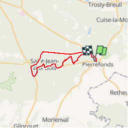
Randonnée Marche de 20 km à découvrir à Hauts-de-France, Oise, Pierrefonds. Cette randonnée est proposée par tracegps.
Description
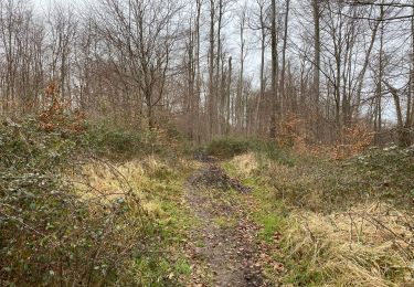
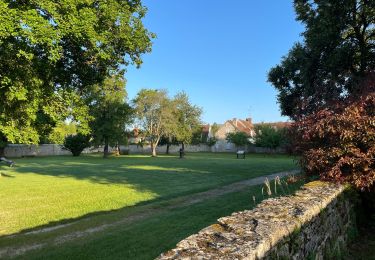
Rando dans la forêt de Compiègne. Départ et arrivée au château de Pierrefonds ( parking). Petite grimpette au départ pour avoir une belle vue , puis ensuite forêt, forêt , forêt... Longue , très longue ligne droite terminale sur la piste cyclable pour finir.
Localisation
Pays :
France
Région :
Hauts-de-France
Département/Province :
Oise
Commune :
Pierrefonds
Localité :
Unknown
Départ:(Dec)
Départ:(UTM)
498134 ; 5466309 (31U) N.
Commentaires
Randonnées à proximité
![Randonnée A pied Pierrefonds - Le Voliard - Photo](https://media.geolcdn.com/t/375/260/4781613a-076f-4ad8-be25-8d021ddb8fa3.jpeg&format=jpg&maxdim=2)
![A pied A pied](https://static1.geolcdn.com/sitytour/trail-icons/100.png)
Le Voliard
A pied
Facile
(1)
Pierrefonds,
Hauts-de-France,
Oise,
France
![](/images/other/stat-length.png)
5,2 km | 6,4 km-effort
1h 27min
![](https://static1.geolcdn.com/siteimages/upload/files/16400158638029165_repeat_loop_refresh_sync_direction_icon.png)
Non
![Randonnée Marche Pierrefonds - Rando couscous ATPC ARVAL 4/2/2024 - Photo](https://media.geolcdn.com/t/375/260/ext.jpg?maxdim=2&url=https%3A%2F%2Fstatic1.geolcdn.com%2Fsiteimages%2Fupload%2Ffiles%2F1553511878bg_sport_marche.png)
![Marche Marche](https://static1.geolcdn.com/sitytour/trail-icons/101.png)
Rando couscous ATPC ARVAL 4/2/2024
Marche
Moyen
(1)
Pierrefonds,
Hauts-de-France,
Oise,
France
![](/images/other/stat-length.png)
9,6 km | 11,9 km-effort
2h 42min
![](https://static1.geolcdn.com/siteimages/upload/files/16400158638029165_repeat_loop_refresh_sync_direction_icon.png)
Oui
![Randonnée Marche Saint-Jean-aux-Bois - SAINT JEAN AUX BOIS, le village et les bois - Photo](https://media.geolcdn.com/t/375/260/cbd4d574-4b06-4403-8920-57abc85ecbc5.jpg&format=jpg&maxdim=2)
![Marche Marche](https://static1.geolcdn.com/sitytour/trail-icons/101.png)
SAINT JEAN AUX BOIS, le village et les bois
Marche
Facile
Saint-Jean-aux-Bois,
Hauts-de-France,
Oise,
France
![](/images/other/stat-length.png)
4,6 km | 5,2 km-effort
1h 11min
![](https://static1.geolcdn.com/siteimages/upload/files/16400158638029165_repeat_loop_refresh_sync_direction_icon.png)
Oui
![Randonnée Marche Vieux-Moulin - Rando douce Vieux moulin 14/8/2022 - Photo](https://media.geolcdn.com/t/375/260/ext.jpg?maxdim=2&url=https%3A%2F%2Fstatic1.geolcdn.com%2Fsiteimages%2Fupload%2Ffiles%2F1553511878bg_sport_marche.png)
![Marche Marche](https://static1.geolcdn.com/sitytour/trail-icons/101.png)
Rando douce Vieux moulin 14/8/2022
Marche
Moyen
(1)
Vieux-Moulin,
Hauts-de-France,
Oise,
France
![](/images/other/stat-length.png)
8,7 km | 10,1 km-effort
2h 14min
![](https://static1.geolcdn.com/siteimages/upload/files/16400158638029165_repeat_loop_refresh_sync_direction_icon.png)
Oui
![Randonnée Marche Vieux-Moulin - Gorges du Han - ATPC ARVAL - Photo](https://media.geolcdn.com/t/375/260/ext.jpg?maxdim=2&url=https%3A%2F%2Fstatic1.geolcdn.com%2Fsiteimages%2Fupload%2Ffiles%2F1553511878bg_sport_marche.png)
![Marche Marche](https://static1.geolcdn.com/sitytour/trail-icons/101.png)
Gorges du Han - ATPC ARVAL
Marche
Très facile
(1)
Vieux-Moulin,
Hauts-de-France,
Oise,
France
![](/images/other/stat-length.png)
13,2 km | 16 km-effort
2h 42min
![](https://static1.geolcdn.com/siteimages/upload/files/16400158638029165_repeat_loop_refresh_sync_direction_icon.png)
Oui
![Randonnée Marche Saint-Jean-aux-Bois - Saint Jean au Bois 13,4 km - Photo](https://media.geolcdn.com/t/375/260/ddfb4125-3dc9-462c-8144-537eda5ffbb6.jpg&format=jpg&maxdim=2)
![Marche Marche](https://static1.geolcdn.com/sitytour/trail-icons/101.png)
Saint Jean au Bois 13,4 km
Marche
Facile
Saint-Jean-aux-Bois,
Hauts-de-France,
Oise,
France
![](/images/other/stat-length.png)
13,4 km | 16,3 km-effort
3h 51min
![](https://static1.geolcdn.com/siteimages/upload/files/16400158638029165_repeat_loop_refresh_sync_direction_icon.png)
Oui
![Randonnée A pied Trosly-Breuil - Le Mont-Collet - Photo](https://media.geolcdn.com/t/375/260/ee705b5e-8f72-4c8f-a8a8-b0b1fed66154.jpeg&format=jpg&maxdim=2)
![A pied A pied](https://static1.geolcdn.com/sitytour/trail-icons/100.png)
Le Mont-Collet
A pied
Facile
Trosly-Breuil,
Hauts-de-France,
Oise,
France
![](/images/other/stat-length.png)
4,9 km | 6,6 km-effort
1h 29min
![](https://static1.geolcdn.com/siteimages/upload/files/16400158638029165_repeat_loop_refresh_sync_direction_icon.png)
Oui
![Randonnée Marche Saint-Jean-aux-Bois - en Forêt de Compiègne_39_Saint-Jean-aux-Bois_Mont d'Arcy - Photo](https://media.geolcdn.com/t/375/260/3c417ebf-bdf2-4766-8886-a33a20a9f3eb.jpg&format=jpg&maxdim=2)
![Marche Marche](https://static1.geolcdn.com/sitytour/trail-icons/101.png)
en Forêt de Compiègne_39_Saint-Jean-aux-Bois_Mont d'Arcy
Marche
Très difficile
Saint-Jean-aux-Bois,
Hauts-de-France,
Oise,
France
![](/images/other/stat-length.png)
17,9 km | 21 km-effort
5h 38min
![](https://static1.geolcdn.com/siteimages/upload/files/16400158638029165_repeat_loop_refresh_sync_direction_icon.png)
Oui
![Randonnée Marche Vieux-Moulin - Gorges du Han - Photo](https://media.geolcdn.com/t/375/260/ext.jpg?maxdim=2&url=https%3A%2F%2Fstatic1.geolcdn.com%2Fsiteimages%2Fupload%2Ffiles%2F1553511878bg_sport_marche.png)
![Marche Marche](https://static1.geolcdn.com/sitytour/trail-icons/101.png)
Gorges du Han
Marche
Très facile
(1)
Vieux-Moulin,
Hauts-de-France,
Oise,
France
![](/images/other/stat-length.png)
11,5 km | 13,8 km-effort
2h 42min
![](https://static1.geolcdn.com/siteimages/upload/files/16400158638029165_repeat_loop_refresh_sync_direction_icon.png)
Oui