![](/images/other/stat-length.png)
![Randonnée V.T.T. Saint-Nicolas-des-Bois - Rocher du Vignage - Alençon - Photo](https://media.geolcdn.com/t/1900/400/ext.pjpeg?maxdim=2&url=https%3A%2F%2Fstatic1.geolcdn.com%2Fsiteimages%2Fupload%2Ffiles%2F1524743154velo.jpg)
Rocher du Vignage - Alençon
tracegps
Utilisateur
![Longueur](/images/other/stat-length.png)
![Altitude max](https://static1.geolcdn.com/siteimages/upload/files/1508320355ic_sort_altitude_max_24dp.png)
![Dénivelé positif](https://static1.geolcdn.com/siteimages/upload/files/1508320355ic_sort_den_pos_24dp.png)
![Km-Effort](/images/other/stat-length.png)
![Altitude min](https://static1.geolcdn.com/siteimages/upload/files/1508320355ic_sort_altitude_min_24dp.png)
![Dénivelé négatif](https://static1.geolcdn.com/siteimages/upload/files/1508320355ic_sort_den_neg_24dp.png)
![Boucle](https://static1.geolcdn.com/siteimages/upload/files/16400158638029165_repeat_loop_refresh_sync_direction_icon.png)
![V.T.T.](https://static1.geolcdn.com/sitytour/trail-icons/202.png)
34m
Difficulté : Moyen
![Scannez ce code QR pour ouvrir la randonnée dans l'application SityTrail](https://capi.geolives.com/qq0zvz2zws4bq2lad0pu/sitytour/trails/105481/qr.png?size=200)
Application GPS de randonnée GRATUITE
À propos
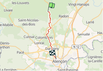
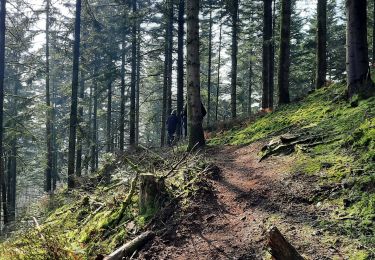
Randonnée V.T.T. de 11 km à découvrir à Normandie, Orne, Saint-Nicolas-des-Bois. Cette randonnée est proposée par tracegps.
Description
Ce parcours assez court a un profil plutôt descendant. De plus, il est très roulant. Sorte d'étape XL d'un Enduro, cette trace vous permet d'envoyer tout au long du parcours pour un sprint de 30min. Il permet aussi de rentrer du Rocher du Vignage vers Alençon sans utiliser une seule fois la route. Allez, essayez de battre ce temps et tenez moi au courant de votre performance dans vos commentaires.
Localisation
Commentaires
Randonnées à proximité
![Randonnée Course à pied Écouves - Carrefour de Radon - Forêt d'Ecouves - Photo](https://media.geolcdn.com/t/375/260/ext.jpg?maxdim=2&url=https%3A%2F%2Fstatic1.geolcdn.com%2Fsiteimages%2Fupload%2Ffiles%2F1524743154running.jpg)
![Course à pied Course à pied](https://static1.geolcdn.com/sitytour/trail-icons/103.png)
Course à pied
![](/images/other/stat-length.png)
![](https://static1.geolcdn.com/siteimages/upload/files/16400158638029165_repeat_loop_refresh_sync_direction_icon.png)
![Randonnée Marche La Ferrière-Béchet - Forêt d'Ecouves - Photo](https://media.geolcdn.com/t/375/260/7f1162e1-a633-458c-ab3d-07f7900cd595.jpg&format=jpg&maxdim=2)
![Marche Marche](https://static1.geolcdn.com/sitytour/trail-icons/101.png)
Marche
![](/images/other/stat-length.png)
![](https://static1.geolcdn.com/siteimages/upload/files/16400158638029165_repeat_loop_refresh_sync_direction_icon.png)
![Randonnée Marche Écouves - OT les Haras de Radon à Damigny - Photo](https://media.geolcdn.com/t/375/260/df76da26-7cd0-46a4-930d-e8df155ac9b3.jpg&format=jpg&maxdim=2)
![Marche Marche](https://static1.geolcdn.com/sitytour/trail-icons/101.png)
Marche
![](/images/other/stat-length.png)
![](https://static1.geolcdn.com/siteimages/upload/files/16400158638029165_repeat_loop_refresh_sync_direction_icon.png)
![Randonnée A pied La Ferrière-Béchet - La Forêt d'Ecouves - Photo](https://media.geolcdn.com/t/375/260/675d0811-d27b-41a7-920a-4c5ad0f0683f.jpeg&format=jpg&maxdim=2)
![A pied A pied](https://static1.geolcdn.com/sitytour/trail-icons/100.png)
A pied
![](/images/other/stat-length.png)
![](https://static1.geolcdn.com/siteimages/upload/files/16400158638029165_repeat_loop_refresh_sync_direction_icon.png)
![Randonnée Marche nordique Écouves - sur les chemins de trail en Ecouves - Photo](https://media.geolcdn.com/t/375/260/239b35b7-9099-4e46-9d0b-e199d379e5df.jpg&format=jpg&maxdim=2)
![Marche nordique Marche nordique](https://static1.geolcdn.com/sitytour/trail-icons/102.png)
Marche nordique
![](/images/other/stat-length.png)
![](https://static1.geolcdn.com/siteimages/upload/files/16400158638029165_repeat_loop_refresh_sync_direction_icon.png)
![Randonnée Cheval Saint-Nicolas-des-Bois - Attelage en forêt d'Écouves - Saint Nicolas des Bois - Photo](https://media.geolcdn.com/t/375/260/ext.jpg?maxdim=2&url=https%3A%2F%2Fservices.sitytrail.com%2FGeolivesWS%2FDownloadMedia.ashx%3FTrailID%3D112046%26Media%3D9574_1.jpg)
![Cheval Cheval](https://static1.geolcdn.com/sitytour/trail-icons/300.png)
Cheval
![](/images/other/stat-length.png)
![](https://static1.geolcdn.com/siteimages/upload/files/16400158638029165_repeat_loop_refresh_sync_direction_icon.png)
![Randonnée Marche L'Orée-d'Écouves - Aux portes d'Alençon - Rochers du Vignage - Photo](https://media.geolcdn.com/t/375/260/ext.jpg?maxdim=2&url=https%3A%2F%2Fservices.sitytrail.com%2FGeolivesWS%2FDownloadMedia.ashx%3FTrailID%3D111642%26Media%3D7886_2.jpg)
![Marche Marche](https://static1.geolcdn.com/sitytour/trail-icons/101.png)
Marche
![](/images/other/stat-length.png)
![](https://static1.geolcdn.com/siteimages/upload/files/16400158638029165_repeat_loop_refresh_sync_direction_icon.png)
![Randonnée Marche Le Bouillon - Alençon : La Forêt d'Écouves - Photo](https://media.geolcdn.com/t/375/260/ext.jpg?maxdim=2&url=https%3A%2F%2Fservices.sitytrail.com%2FGeolivesWS%2FDownloadMedia.ashx%3FTrailID%3D111641%26Media%3D7885_1.jpg)
![Marche Marche](https://static1.geolcdn.com/sitytour/trail-icons/101.png)
Marche
![](/images/other/stat-length.png)
![](https://static1.geolcdn.com/siteimages/upload/files/16400158638029165_repeat_loop_refresh_sync_direction_icon.png)
![Randonnée Voiture L'Orée-d'Écouves - 2025-01-08 Ecouves VduP - Photo](https://media.geolcdn.com/t/375/260/ext.jpg?maxdim=2&url=https%3A%2F%2Fstatic1.geolcdn.com%2Fsiteimages%2Fupload%2Ffiles%2F15247431544x4.jpg)
![Voiture Voiture](https://static1.geolcdn.com/sitytour/trail-icons/401.png)
Voiture
![](/images/other/stat-length.png)
![](https://static1.geolcdn.com/siteimages/upload/files/16400158638029165_repeat_loop_refresh_sync_direction_icon.png)