![](/images/other/stat-length.png)
![Randonnée V.T.T. Châlons-en-Champagne - Vallée et Champagne crayeuse - Photo](https://media.geolcdn.com/t/1900/400/ext.pjpeg?maxdim=2&url=https%3A%2F%2Fstatic1.geolcdn.com%2Fsiteimages%2Fupload%2Ffiles%2F1524743154velo.jpg)
Vallée et Champagne crayeuse
tracegps
Utilisateur
![Longueur](/images/other/stat-length.png)
![Altitude max](https://static1.geolcdn.com/siteimages/upload/files/1508320355ic_sort_altitude_max_24dp.png)
![Dénivelé positif](https://static1.geolcdn.com/siteimages/upload/files/1508320355ic_sort_den_pos_24dp.png)
![Km-Effort](/images/other/stat-length.png)
![Altitude min](https://static1.geolcdn.com/siteimages/upload/files/1508320355ic_sort_altitude_min_24dp.png)
![Dénivelé négatif](https://static1.geolcdn.com/siteimages/upload/files/1508320355ic_sort_den_neg_24dp.png)
![Boucle](https://static1.geolcdn.com/siteimages/upload/files/16400158638029165_repeat_loop_refresh_sync_direction_icon.png)
![V.T.T.](https://static1.geolcdn.com/sitytour/trail-icons/202.png)
2h30
Difficulté : Moyen
![Scannez ce code QR pour ouvrir la randonnée dans l'application SityTrail](https://capi.geolives.com/qq0zvz2zws4bq2lad0pu/sitytour/trails/105475/qr.png?size=200)
Application GPS de randonnée GRATUITE
À propos
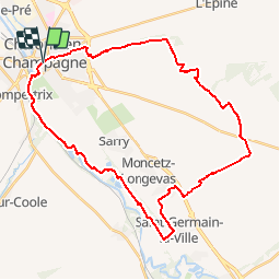
Randonnée V.T.T. de 35 km à découvrir à Grand Est, Marne, Châlons-en-Champagne. Cette randonnée est proposée par tracegps.
Description
Ce circuit prévu pour le VTT (voire le VTC) ne présente pas de difficultés. Il débute à Châlons-en-Champagne et suit la Marne (au départ sur un sentier aménagé, puis ensuite sur différents chemins). La seconde partie, après la traversée de la nationale 44 se déroule dans la grande plaine de champagne crayeuse. Il y aura là, contrairement à la première partie , quelques montées et quelques descentes, mais cela reste abordable ! J'ai essayé de longer quelques bosquets relictuels en Champagne crayeuse ou des haies. Cela permet d'observer lapins et chevreuils (en circulant peu après l'aube ou au crépuscule). Le retour se fait par le bois du Bauchet. Comme ce circuit comporte très peu de passages goudronnés, il est préférable de le faire par temps sec
Localisation
Commentaires
Randonnées à proximité
![Randonnée Vélo électrique Châlons-en-Champagne - Chalons en Champagne Vitry le François - Photo](https://media.geolcdn.com/t/375/260/ext.jpg?maxdim=2&url=https%3A%2F%2Fmedia.geolcdn.com%2Ff%2F5bc9c910-f226-4293-9bb0-fa4533d75a4a.jpg)
![Vélo électrique Vélo électrique](https://static1.geolcdn.com/sitytour/trail-icons/205.png)
Vélo électrique
![](/images/other/stat-length.png)
![](https://static1.geolcdn.com/siteimages/upload/files/16400158638029165_repeat_loop_refresh_sync_direction_icon.png)
![Randonnée Marche Châlons-en-Champagne - La Via Francigena - Châlons en Champagne- Vitry le François - Photo](https://media.geolcdn.com/t/375/260/ext.jpg?maxdim=2&url=https%3A%2F%2Fservices.sitytrail.com%2FGeolivesWS%2FDownloadMedia.ashx%3FTrailID%3D112742%26Media%3D11836_4.jpg)
![Marche Marche](https://static1.geolcdn.com/sitytour/trail-icons/101.png)
Marche
![](/images/other/stat-length.png)
![](https://static1.geolcdn.com/siteimages/upload/files/16400158638029165_repeat_loop_refresh_sync_direction_icon.png)
![Randonnée Marche Châlons-en-Champagne - Chemin de Compostelle, Voie de Vézelay GR654® De Châlons en Champagne à La Chaussée sur Marne - Photo](https://media.geolcdn.com/t/375/260/ext.jpg?maxdim=2&url=https%3A%2F%2Fservices.sitytrail.com%2FGeolivesWS%2FDownloadMedia.ashx%3FTrailID%3D109404%26Media%3D3735_1.jpg)
![Marche Marche](https://static1.geolcdn.com/sitytour/trail-icons/101.png)
Marche
![](/images/other/stat-length.png)
![](https://static1.geolcdn.com/siteimages/upload/files/16400158638029165_repeat_loop_refresh_sync_direction_icon.png)
![Randonnée Marche nordique Châlons-en-Champagne - Châlons en Champagnbe 10 620m +54m - Photo](https://media.geolcdn.com/t/375/260/ext.jpg?maxdim=2&url=https%3A%2F%2Fstatic1.geolcdn.com%2Fsiteimages%2Fupload%2Ffiles%2F1545311037marcheuse_200dpi.jpg)
![Marche nordique Marche nordique](https://static1.geolcdn.com/sitytour/trail-icons/102.png)
Marche nordique
![](/images/other/stat-length.png)
![](https://static1.geolcdn.com/siteimages/upload/files/16400158638029165_repeat_loop_refresh_sync_direction_icon.png)
![Randonnée Cyclotourisme Châlons-en-Champagne - Chalons - Sainte-Marie du Lac 62 km - Photo](https://media.geolcdn.com/t/375/260/ext.jpg?maxdim=2&url=https%3A%2F%2Fstatic1.geolcdn.com%2Fsiteimages%2Fupload%2Ffiles%2F1524743154velo.jpg)
![Cyclotourisme Cyclotourisme](https://static1.geolcdn.com/sitytour/trail-icons/204.png)
Cyclotourisme
![](/images/other/stat-length.png)
![](https://static1.geolcdn.com/siteimages/upload/files/16400158638029165_repeat_loop_refresh_sync_direction_icon.png)
![Randonnée Vélo Châlons-en-Champagne - 20070610Arcis - Photo](https://media.geolcdn.com/t/375/260/ext.jpg?maxdim=2&url=https%3A%2F%2Fstatic1.geolcdn.com%2Fsiteimages%2Fupload%2Ffiles%2F1524743154velo.jpg)
![Vélo Vélo](https://static1.geolcdn.com/sitytour/trail-icons/200.png)
Vélo
![](/images/other/stat-length.png)
![](https://static1.geolcdn.com/siteimages/upload/files/16400158638029165_repeat_loop_refresh_sync_direction_icon.png)
![Randonnée Marche nordique Recy - recy 10,5 km 13 02 2024 - Photo](https://media.geolcdn.com/t/375/260/ext.jpg?maxdim=2&url=https%3A%2F%2Fstatic1.geolcdn.com%2Fsiteimages%2Fupload%2Ffiles%2F1545311037marcheuse_200dpi.jpg)
![Marche nordique Marche nordique](https://static1.geolcdn.com/sitytour/trail-icons/102.png)
Marche nordique
![](/images/other/stat-length.png)
![](https://static1.geolcdn.com/siteimages/upload/files/16400158638029165_repeat_loop_refresh_sync_direction_icon.png)
![Randonnée Marche Châlons-en-Champagne - L'Epine 19 500m +130m - Photo](https://media.geolcdn.com/t/375/260/ext.jpg?maxdim=2&url=https%3A%2F%2Fstatic1.geolcdn.com%2Fsiteimages%2Fupload%2Ffiles%2F1553511878bg_sport_marche.png)
![Marche Marche](https://static1.geolcdn.com/sitytour/trail-icons/101.png)
Marche
![](/images/other/stat-length.png)
![](https://static1.geolcdn.com/siteimages/upload/files/16400158638029165_repeat_loop_refresh_sync_direction_icon.png)
![Randonnée Vélo Saint-Martin-sur-le-Pré - M3 - Chalons -Verdun - Photo](https://media.geolcdn.com/t/375/260/ext.jpg?maxdim=2&url=https%3A%2F%2Fstatic1.geolcdn.com%2Fsiteimages%2Fupload%2Ffiles%2F1524743154velo.jpg)
![Vélo Vélo](https://static1.geolcdn.com/sitytour/trail-icons/200.png)
Vélo
![](/images/other/stat-length.png)
![](https://static1.geolcdn.com/siteimages/upload/files/16400158638029165_repeat_loop_refresh_sync_direction_icon.png)