![](/images/other/stat-length.png)
![Randonnée V.T.T. Goyrans - Goyrans - Clermont le Fort - Photo](https://media.geolcdn.com/t/1900/400/ext.pjpeg?maxdim=2&url=https%3A%2F%2Fstatic1.geolcdn.com%2Fsiteimages%2Fupload%2Ffiles%2F1524743154velo.jpg)
Goyrans - Clermont le Fort
tracegps
Utilisateur
![Longueur](/images/other/stat-length.png)
Longueur
22 km
![Altitude max](https://static1.geolcdn.com/siteimages/upload/files/1508320355ic_sort_altitude_max_24dp.png)
Altitude max
283 m
![Dénivelé positif](https://static1.geolcdn.com/siteimages/upload/files/1508320355ic_sort_den_pos_24dp.png)
Dénivelé positif
506 m
![Km-Effort](/images/other/stat-length.png)
Km-Effort
29 km
![Altitude min](https://static1.geolcdn.com/siteimages/upload/files/1508320355ic_sort_altitude_min_24dp.png)
Altitude min
155 m
![Dénivelé négatif](https://static1.geolcdn.com/siteimages/upload/files/1508320355ic_sort_den_neg_24dp.png)
Dénivelé négatif
502 m
![Boucle](https://static1.geolcdn.com/siteimages/upload/files/16400158638029165_repeat_loop_refresh_sync_direction_icon.png)
Boucle
Oui
Date de création :
2014-12-10 00:00:00.0
Dernière modification :
2014-12-10 00:00:00.0
![V.T.T.](https://static1.geolcdn.com/sitytour/trail-icons/202.png)
1h45
Difficulté : Difficile
![Scannez ce code QR pour ouvrir la randonnée dans l'application SityTrail](https://capi.geolives.com/qq0zvz2zws4bq2lad0pu/sitytour/trails/105436/qr.png?size=200)
Application GPS de randonnée GRATUITE
À propos
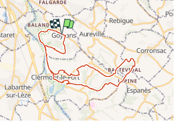
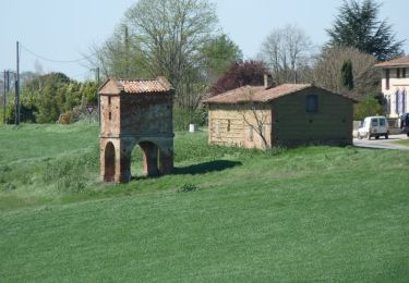
Randonnée V.T.T. de 22 km à découvrir à Occitanie, Haute-Garonne, Goyrans. Cette randonnée est proposée par tracegps.
Description
Boucle dans les coteaux autour de Goyrans, à 15min de Toulouse : succession de montées sur route ou chemins carrossables et de descentes sur sentiers roulants ou techniques, passage par le bord de l'Ariège, par Clermont le Fort, retour à Goyrans. Excellent parcours !
Localisation
Pays :
France
Région :
Occitanie
Département/Province :
Haute-Garonne
Commune :
Goyrans
Localité :
Unknown
Départ:(Dec)
Départ:(UTM)
373167 ; 4815497 (31T) N.
Commentaires
Randonnées à proximité
![Randonnée V.T.T. Pins-Justaret - De Pins Justaret à Clermont Le Fort - Photo](https://media.geolcdn.com/t/375/260/ext.jpg?maxdim=2&url=https%3A%2F%2Fservices.sitytrail.com%2FGeolivesWS%2FDownloadMedia.ashx%3FTrailID%3D103881%26Media%3D6697_1.jpg)
![V.T.T. V.T.T.](https://static1.geolcdn.com/sitytour/trail-icons/202.png)
De Pins Justaret à Clermont Le Fort
V.T.T.
Moyen
(1)
Pins-Justaret,
Occitanie,
Haute-Garonne,
France
![](/images/other/stat-length.png)
30 km | 35 km-effort
2h 30min
![](https://static1.geolcdn.com/siteimages/upload/files/16400158638029165_repeat_loop_refresh_sync_direction_icon.png)
Oui
![Randonnée V.T.T. Aureville - Aureville à Goyrans - Photo](https://media.geolcdn.com/t/375/260/ext.jpg?maxdim=2&url=https%3A%2F%2Fservices.sitytrail.com%2FGeolivesWS%2FDownloadMedia.ashx%3FTrailID%3D100828%26Media%3D334_1.jpg)
![V.T.T. V.T.T.](https://static1.geolcdn.com/sitytour/trail-icons/202.png)
Aureville à Goyrans
V.T.T.
Moyen
(1)
Aureville,
Occitanie,
Haute-Garonne,
France
![](/images/other/stat-length.png)
14,9 km | 19,4 km-effort
1h 0min
![](https://static1.geolcdn.com/siteimages/upload/files/16400158638029165_repeat_loop_refresh_sync_direction_icon.png)
Oui
![Randonnée Marche Aureville - Aureville à Goyrans - Photo](https://media.geolcdn.com/t/375/260/ext.jpg?maxdim=2&url=https%3A%2F%2Fservices.sitytrail.com%2FGeolivesWS%2FDownloadMedia.ashx%3FTrailID%3D100827%26Media%3D334_1.jpg)
![Marche Marche](https://static1.geolcdn.com/sitytour/trail-icons/101.png)
Aureville à Goyrans
Marche
Moyen
(1)
Aureville,
Occitanie,
Haute-Garonne,
France
![](/images/other/stat-length.png)
14,9 km | 19,4 km-effort
3h 0min
![](https://static1.geolcdn.com/siteimages/upload/files/16400158638029165_repeat_loop_refresh_sync_direction_icon.png)
Oui
![Randonnée A pied Clermont-le-Fort - Boucle de Notre-Dame des Bois - Photo](https://media.geolcdn.com/t/375/260/e1f90de5-cc91-4dad-8b4b-10709a088f34.jpeg&format=jpg&maxdim=2)
![A pied A pied](https://static1.geolcdn.com/sitytour/trail-icons/100.png)
Boucle de Notre-Dame des Bois
A pied
Facile
Clermont-le-Fort,
Occitanie,
Haute-Garonne,
France
![](/images/other/stat-length.png)
10,9 km | 14,1 km-effort
3h 12min
![](https://static1.geolcdn.com/siteimages/upload/files/16400158638029165_repeat_loop_refresh_sync_direction_icon.png)
Oui
![Randonnée Marche Clermont-le-Fort - L'Ariège de Clermont Le Fort à Vénerque - Photo](https://media.geolcdn.com/t/375/260/ext.jpg?maxdim=2&url=https%3A%2F%2Fstatic1.geolcdn.com%2Fsiteimages%2Fupload%2Ffiles%2F1553511878bg_sport_marche.png)
![Marche Marche](https://static1.geolcdn.com/sitytour/trail-icons/101.png)
L'Ariège de Clermont Le Fort à Vénerque
Marche
Moyen
(2)
Clermont-le-Fort,
Occitanie,
Haute-Garonne,
France
![](/images/other/stat-length.png)
9,2 km | 12,2 km-effort
2h 0min
![](https://static1.geolcdn.com/siteimages/upload/files/16400158638029165_repeat_loop_refresh_sync_direction_icon.png)
Oui
![Randonnée Marche Pinsaguel - PINSAGUEL : sentier de la Confluence (24.08.2023) - Photo](https://media.geolcdn.com/t/375/260/5aa31e1f-7793-4ca5-be24-5547b9d33073.jpg&format=jpg&maxdim=2)
![Marche Marche](https://static1.geolcdn.com/sitytour/trail-icons/101.png)
PINSAGUEL : sentier de la Confluence (24.08.2023)
Marche
Très facile
Pinsaguel,
Occitanie,
Haute-Garonne,
France
![](/images/other/stat-length.png)
3,8 km | 4,4 km-effort
1h 15min
![](https://static1.geolcdn.com/siteimages/upload/files/16400158638029165_repeat_loop_refresh_sync_direction_icon.png)
Oui
![Randonnée Vélo Roques - Canal du midi de Roques à carcassonne - Photo](https://media.geolcdn.com/t/375/260/ext.jpg?maxdim=2&url=https%3A%2F%2Fservices.sitytrail.com%2FGeolivesWS%2FDownloadMedia.ashx%3FTrailID%3D450849%26Media%3D318200dd-6806-40ce-9c90-5b09cbf921f9.jpg)
![Vélo Vélo](https://static1.geolcdn.com/sitytour/trail-icons/200.png)
Canal du midi de Roques à carcassonne
Vélo
Facile
Roques,
Occitanie,
Haute-Garonne,
France
![](/images/other/stat-length.png)
106 km | 116 km-effort
6h 39min
![](https://static1.geolcdn.com/siteimages/upload/files/16400158638029165_repeat_loop_refresh_sync_direction_icon.png)
Non
![Randonnée V.T.T. Pins-Justaret - Pins justaret - Photo](https://media.geolcdn.com/t/375/260/ext.jpg?maxdim=2&url=https%3A%2F%2Fstatic1.geolcdn.com%2Fsiteimages%2Fupload%2Ffiles%2F1524743154velo.jpg)
![V.T.T. V.T.T.](https://static1.geolcdn.com/sitytour/trail-icons/202.png)
Pins justaret
V.T.T.
Facile
(1)
Pins-Justaret,
Occitanie,
Haute-Garonne,
France
![](/images/other/stat-length.png)
34 km | 40 km-effort
2h 49min
![](https://static1.geolcdn.com/siteimages/upload/files/16400158638029165_repeat_loop_refresh_sync_direction_icon.png)
Oui
![Randonnée Marche Espanès - Pigeonnier de Barèges - Espanès - Photo](https://media.geolcdn.com/t/375/260/ext.jpg?maxdim=2&url=https%3A%2F%2Fservices.sitytrail.com%2FGeolivesWS%2FDownloadMedia.ashx%3FTrailID%3D317597%26Media%3D16865_4.jpg)
![Marche Marche](https://static1.geolcdn.com/sitytour/trail-icons/101.png)
Pigeonnier de Barèges - Espanès
Marche
Moyen
Espanès,
Occitanie,
Haute-Garonne,
France
![](/images/other/stat-length.png)
6,7 km | 8,6 km-effort
2h 30min
![](https://static1.geolcdn.com/siteimages/upload/files/16400158638029165_repeat_loop_refresh_sync_direction_icon.png)
Oui