![](/images/other/stat-length.png)
![Randonnée V.T.T. Fougères - Fougères - boucle 12 - Photo](https://media.geolcdn.com/t/1900/400/ext.pjpeg?maxdim=2&url=https%3A%2F%2Fstatic1.geolcdn.com%2Fsiteimages%2Fupload%2Ffiles%2F1524743154velo.jpg)
Fougères - boucle 12
tracegps
Utilisateur
![Longueur](/images/other/stat-length.png)
Longueur
9 km
![Altitude max](https://static1.geolcdn.com/siteimages/upload/files/1508320355ic_sort_altitude_max_24dp.png)
Altitude max
178 m
![Dénivelé positif](https://static1.geolcdn.com/siteimages/upload/files/1508320355ic_sort_den_pos_24dp.png)
Dénivelé positif
121 m
![Km-Effort](/images/other/stat-length.png)
Km-Effort
10,6 km
![Altitude min](https://static1.geolcdn.com/siteimages/upload/files/1508320355ic_sort_altitude_min_24dp.png)
Altitude min
97 m
![Dénivelé négatif](https://static1.geolcdn.com/siteimages/upload/files/1508320355ic_sort_den_neg_24dp.png)
Dénivelé négatif
119 m
![Boucle](https://static1.geolcdn.com/siteimages/upload/files/16400158638029165_repeat_loop_refresh_sync_direction_icon.png)
Boucle
Oui
Date de création :
2014-12-10 00:00:00.0
Dernière modification :
2014-12-10 00:00:00.0
![V.T.T.](https://static1.geolcdn.com/sitytour/trail-icons/202.png)
30m
Difficulté : Facile
![Scannez ce code QR pour ouvrir la randonnée dans l'application SityTrail](https://capi.geolives.com/qq0zvz2zws4bq2lad0pu/sitytour/trails/105416/qr.png?size=200)
Application GPS de randonnée GRATUITE
À propos
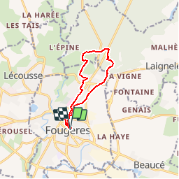
Randonnée V.T.T. de 9 km à découvrir à Bretagne, Ille-et-Vilaine, Fougères. Cette randonnée est proposée par tracegps.
Description
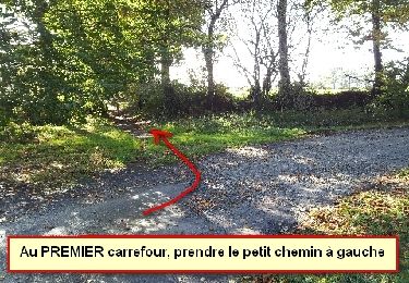
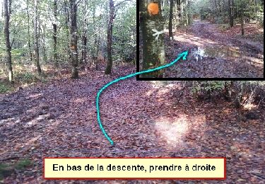
Depuis le cinéma de Fougères, remontée en direction de la route de Vire puis bifurcation vers la gauche et entrée dans la foret de Fougères traversée allègrement avant de redescendre le long d'un talweg.
Localisation
Pays :
France
Région :
Bretagne
Département/Province :
Ille-et-Vilaine
Commune :
Fougères
Localité :
Unknown
Départ:(Dec)
Départ:(UTM)
633792 ; 5356835 (30U) N.
Commentaires
Randonnées à proximité
![Randonnée A pied Landéan - Les Vieux Châteaux - Photo](https://media.geolcdn.com/t/375/260/122c427c-456b-4f47-979b-0a8d83dc03ab.jpeg&format=jpg&maxdim=2)
![A pied A pied](https://static1.geolcdn.com/sitytour/trail-icons/100.png)
Les Vieux Châteaux
A pied
Facile
(1)
Landéan,
Bretagne,
Ille-et-Vilaine,
France
![](/images/other/stat-length.png)
5,3 km | 6,3 km-effort
1h 26min
![](https://static1.geolcdn.com/siteimages/upload/files/16400158638029165_repeat_loop_refresh_sync_direction_icon.png)
Oui
![Randonnée A pied Landéan - La Longue Noë - Photo](https://media.geolcdn.com/t/375/260/f327ed77-355c-4519-bce4-a684f55ad906.jpeg&format=jpg&maxdim=2)
![A pied A pied](https://static1.geolcdn.com/sitytour/trail-icons/100.png)
La Longue Noë
A pied
Facile
Landéan,
Bretagne,
Ille-et-Vilaine,
France
![](/images/other/stat-length.png)
6,2 km | 7,4 km-effort
1h 41min
![](https://static1.geolcdn.com/siteimages/upload/files/16400158638029165_repeat_loop_refresh_sync_direction_icon.png)
Oui
![Randonnée Marche nordique Landéan - Poulailler autour du Moulin d'Avion 12,5km - Photo](https://media.geolcdn.com/t/375/260/ext.jpg?maxdim=2&url=https%3A%2F%2Fservices.sitytrail.com%2FGeolivesWS%2FDownloadMedia.ashx%3FTrailID%3D676451%26Media%3Dcc3eee66-6e8e-4acd-8735-e9a30f06fcf1.jpeg)
![Marche nordique Marche nordique](https://static1.geolcdn.com/sitytour/trail-icons/102.png)
Poulailler autour du Moulin d'Avion 12,5km
Marche nordique
Moyen
Landéan,
Bretagne,
Ille-et-Vilaine,
France
![](/images/other/stat-length.png)
12,5 km | 14,9 km-effort
2h 10min
![](https://static1.geolcdn.com/siteimages/upload/files/16400158638029165_repeat_loop_refresh_sync_direction_icon.png)
Oui
![Randonnée Marche nordique Landéan - Poulailler Chénedet 10,4km - Photo](https://media.geolcdn.com/t/375/260/ext.jpg?maxdim=2&url=https%3A%2F%2Fservices.sitytrail.com%2FGeolivesWS%2FDownloadMedia.ashx%3FTrailID%3D676433%26Media%3Dc418e412-7874-4576-9726-02eef27b2c32.jpg)
![Marche nordique Marche nordique](https://static1.geolcdn.com/sitytour/trail-icons/102.png)
Poulailler Chénedet 10,4km
Marche nordique
Moyen
Landéan,
Bretagne,
Ille-et-Vilaine,
France
![](/images/other/stat-length.png)
10,3 km | 12,5 km-effort
2h 50min
![](https://static1.geolcdn.com/siteimages/upload/files/16400158638029165_repeat_loop_refresh_sync_direction_icon.png)
Oui
![Randonnée Marche nordique Landéan - CMN Albert 10km - Photo](https://media.geolcdn.com/t/375/260/ext.jpg?maxdim=2&url=https%3A%2F%2Fservices.sitytrail.com%2FGeolivesWS%2FDownloadMedia.ashx%3FTrailID%3D189602%26Media%3D27502648-31d9-4ef3-b6ad-5dd7e3ce8752.jpg)
![Marche nordique Marche nordique](https://static1.geolcdn.com/sitytour/trail-icons/102.png)
CMN Albert 10km
Marche nordique
Moyen
Landéan,
Bretagne,
Ille-et-Vilaine,
France
![](/images/other/stat-length.png)
9,9 km | 12 km-effort
1h 40min
![](https://static1.geolcdn.com/siteimages/upload/files/16400158638029165_repeat_loop_refresh_sync_direction_icon.png)
Oui
![Randonnée Marche nordique Landéan - CMN Françoise 10 - Photo](https://media.geolcdn.com/t/375/260/ext.jpg?maxdim=2&url=https%3A%2F%2Fservices.sitytrail.com%2FGeolivesWS%2FDownloadMedia.ashx%3FTrailID%3D188449%26Media%3D09b0d8a3-5ae2-461c-ad1f-fb0e22cf207f.jpg)
![Marche nordique Marche nordique](https://static1.geolcdn.com/sitytour/trail-icons/102.png)
CMN Françoise 10
Marche nordique
Moyen
Landéan,
Bretagne,
Ille-et-Vilaine,
France
![](/images/other/stat-length.png)
10,5 km | 12,5 km-effort
1h 50min
![](https://static1.geolcdn.com/siteimages/upload/files/16400158638029165_repeat_loop_refresh_sync_direction_icon.png)
Oui
![Randonnée Marche nordique Landéan - Léandre - Photo](https://media.geolcdn.com/t/375/260/ext.jpg?maxdim=2&url=https%3A%2F%2Fservices.sitytrail.com%2FGeolivesWS%2FDownloadMedia.ashx%3FTrailID%3D187651%26Media%3D263e6600-ee89-4974-b42c-0cf56a92d847.jpg)
![Marche nordique Marche nordique](https://static1.geolcdn.com/sitytour/trail-icons/102.png)
Léandre
Marche nordique
Moyen
Landéan,
Bretagne,
Ille-et-Vilaine,
France
![](/images/other/stat-length.png)
12,4 km | 14,9 km-effort
2h 20min
![](https://static1.geolcdn.com/siteimages/upload/files/16400158638029165_repeat_loop_refresh_sync_direction_icon.png)
Oui
![Randonnée Marche nordique Landéan - CMN Du Poulailler dans la ville 15 km - Photo](https://media.geolcdn.com/t/375/260/ext.jpg?maxdim=2&url=https%3A%2F%2Fservices.sitytrail.com%2FGeolivesWS%2FDownloadMedia.ashx%3FTrailID%3D162112%26Media%3D9e9344dd-ab74-44da-9479-e497c8838235.jpeg)
![Marche nordique Marche nordique](https://static1.geolcdn.com/sitytour/trail-icons/102.png)
CMN Du Poulailler dans la ville 15 km
Marche nordique
Moyen
Landéan,
Bretagne,
Ille-et-Vilaine,
France
![](/images/other/stat-length.png)
14,9 km | 18 km-effort
2h 50min
![](https://static1.geolcdn.com/siteimages/upload/files/16400158638029165_repeat_loop_refresh_sync_direction_icon.png)
Oui
![Randonnée Marche nordique Landéan - Poulailler à Galoupel 11,6km - Photo](https://media.geolcdn.com/t/375/260/ext.jpg?maxdim=2&url=https%3A%2F%2Fservices.sitytrail.com%2FGeolivesWS%2FDownloadMedia.ashx%3FTrailID%3D162110%26Media%3D413a32e4-2e2a-44c9-a005-215b3d70b193.jpg)
![Marche nordique Marche nordique](https://static1.geolcdn.com/sitytour/trail-icons/102.png)
Poulailler à Galoupel 11,6km
Marche nordique
Moyen
Landéan,
Bretagne,
Ille-et-Vilaine,
France
![](/images/other/stat-length.png)
11,5 km | 13,9 km-effort
2h 10min
![](https://static1.geolcdn.com/siteimages/upload/files/16400158638029165_repeat_loop_refresh_sync_direction_icon.png)
Oui