![](/images/other/stat-length.png)
![Randonnée Marche Lachassagne - Lachassagne (marche des confiture 10/2018) - Photo](https://media.geolcdn.com/t/1900/400/ext.pjpeg?maxdim=2&url=https%3A%2F%2Fstatic1.geolcdn.com%2Fsiteimages%2Fupload%2Ffiles%2F1553511878bg_sport_marche.png)
Lachassagne (marche des confiture 10/2018)
Thomasdanielle
Utilisateur
![Longueur](/images/other/stat-length.png)
Longueur
14,9 km
![Altitude max](https://static1.geolcdn.com/siteimages/upload/files/1508320355ic_sort_altitude_max_24dp.png)
Altitude max
409 m
![Dénivelé positif](https://static1.geolcdn.com/siteimages/upload/files/1508320355ic_sort_den_pos_24dp.png)
Dénivelé positif
401 m
![Km-Effort](/images/other/stat-length.png)
Km-Effort
20 km
![Altitude min](https://static1.geolcdn.com/siteimages/upload/files/1508320355ic_sort_altitude_min_24dp.png)
Altitude min
229 m
![Dénivelé négatif](https://static1.geolcdn.com/siteimages/upload/files/1508320355ic_sort_den_neg_24dp.png)
Dénivelé négatif
397 m
![Boucle](https://static1.geolcdn.com/siteimages/upload/files/16400158638029165_repeat_loop_refresh_sync_direction_icon.png)
Boucle
Oui
Date de création :
2019-01-15 17:21:26.796
Dernière modification :
2019-01-15 17:21:26.796
![Marche](https://static1.geolcdn.com/sitytour/trail-icons/101.png)
4h18
Difficulté : Facile
![Scannez ce code QR pour ouvrir la randonnée dans l'application SityTrail](https://capi.geolives.com/qq0zvz2zws4bq2lad0pu/sitytour/trails/1052196/qr.png?size=200)
Application GPS de randonnée GRATUITE
À propos
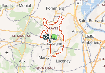
Randonnée Marche de 14,9 km à découvrir à Auvergne-Rhône-Alpes, Rhône, Lachassagne. Cette randonnée est proposée par Thomasdanielle.
Description
D/A parking proche de l'école (15 km D. 400 m)
Nombreux passages dans les vignes, pas de balisage donc difficile de la refaire
Localisation
Pays :
France
Région :
Auvergne-Rhône-Alpes
Département/Province :
Rhône
Commune :
Lachassagne
Localité :
Unknown
Départ:(Dec)
Départ:(UTM)
630746 ; 5087263 (31T) N.
Commentaires
Randonnées à proximité
![Randonnée Marche nordique Bagnols - bagnol - Photo](https://media.geolcdn.com/t/375/260/ext.jpg?maxdim=2&url=https%3A%2F%2Fstatic1.geolcdn.com%2Fsiteimages%2Fupload%2Ffiles%2F1545311037marcheuse_200dpi.jpg)
![Marche nordique Marche nordique](https://static1.geolcdn.com/sitytour/trail-icons/102.png)
bagnol
Marche nordique
Très facile
(1)
Bagnols,
Auvergne-Rhône-Alpes,
Rhône,
France
![](/images/other/stat-length.png)
6,8 km | 8,4 km-effort
1h 40min
![](https://static1.geolcdn.com/siteimages/upload/files/16400158638029165_repeat_loop_refresh_sync_direction_icon.png)
Oui
![Randonnée Marche Morancé - morance - Photo](https://media.geolcdn.com/t/375/260/ext.jpg?maxdim=2&url=https%3A%2F%2Fstatic1.geolcdn.com%2Fsiteimages%2Fupload%2Ffiles%2F1553511878bg_sport_marche.png)
![Marche Marche](https://static1.geolcdn.com/sitytour/trail-icons/101.png)
morance
Marche
Très facile
(1)
Morancé,
Auvergne-Rhône-Alpes,
Rhône,
France
![](/images/other/stat-length.png)
7,9 km | 9,7 km-effort
1h 46min
![](https://static1.geolcdn.com/siteimages/upload/files/16400158638029165_repeat_loop_refresh_sync_direction_icon.png)
Oui
![Randonnée Marche Chessy - Chessy 11 km - Photo](https://media.geolcdn.com/t/375/260/ext.jpg?maxdim=2&url=https%3A%2F%2Fstatic1.geolcdn.com%2Fsiteimages%2Fupload%2Ffiles%2F1553511878bg_sport_marche.png)
![Marche Marche](https://static1.geolcdn.com/sitytour/trail-icons/101.png)
Chessy 11 km
Marche
Difficile
(1)
Chessy,
Auvergne-Rhône-Alpes,
Rhône,
France
![](/images/other/stat-length.png)
11,5 km | 14,9 km-effort
3h 23min
![](https://static1.geolcdn.com/siteimages/upload/files/16400158638029165_repeat_loop_refresh_sync_direction_icon.png)
Oui
![Randonnée Randonnée équestre Les Chères - 5 nov formation - Photo](https://media.geolcdn.com/t/375/260/ext.jpg?maxdim=2&url=https%3A%2F%2Fstatic1.geolcdn.com%2Fsiteimages%2Fupload%2Ffiles%2F1524743154cheval.jpg)
![Randonnée équestre Randonnée équestre](https://static1.geolcdn.com/sitytour/trail-icons/301.png)
5 nov formation
Randonnée équestre
Facile
(2)
Les Chères,
Auvergne-Rhône-Alpes,
Rhône,
France
![](/images/other/stat-length.png)
13,6 km | 15 km-effort
1h 58min
![](https://static1.geolcdn.com/siteimages/upload/files/16400158638029165_repeat_loop_refresh_sync_direction_icon.png)
Oui
![Randonnée Marche Chessy - Chessy à Bagnols - Photo](https://media.geolcdn.com/t/375/260/1a8d6b74-bd94-4883-b228-58b5e533ca39.jpg&format=jpg&maxdim=2)
![Marche Marche](https://static1.geolcdn.com/sitytour/trail-icons/101.png)
Chessy à Bagnols
Marche
Difficile
(1)
Chessy,
Auvergne-Rhône-Alpes,
Rhône,
France
![](/images/other/stat-length.png)
12,5 km | 15,8 km-effort
3h 35min
![](https://static1.geolcdn.com/siteimages/upload/files/16400158638029165_repeat_loop_refresh_sync_direction_icon.png)
Oui
![Randonnée Marche Charnay - Charnay/Châtillon/Chessy (12 km - D. 330 m) - Photo](https://media.geolcdn.com/t/375/260/1a2d3b7e-3e2e-464b-b810-b35fd7c37452.jpeg&format=jpg&maxdim=2)
![Marche Marche](https://static1.geolcdn.com/sitytour/trail-icons/101.png)
Charnay/Châtillon/Chessy (12 km - D. 330 m)
Marche
Facile
Charnay,
Auvergne-Rhône-Alpes,
Rhône,
France
![](/images/other/stat-length.png)
12,5 km | 16,9 km-effort
3h 7min
![](https://static1.geolcdn.com/siteimages/upload/files/16400158638029165_repeat_loop_refresh_sync_direction_icon.png)
Oui
![Randonnée Marche Porte des Pierres Dorées - Jarnioux (8,5 km - D. 249 m) - Photo](https://media.geolcdn.com/t/375/260/5f7dfffa-a5f2-424b-811f-de7ae78c4bcd.jpg&format=jpg&maxdim=2)
![Marche Marche](https://static1.geolcdn.com/sitytour/trail-icons/101.png)
Jarnioux (8,5 km - D. 249 m)
Marche
Porte des Pierres Dorées,
Auvergne-Rhône-Alpes,
Rhône,
France
![](/images/other/stat-length.png)
8,5 km | 11,8 km-effort
2h 42min
![](https://static1.geolcdn.com/siteimages/upload/files/16400158638029165_repeat_loop_refresh_sync_direction_icon.png)
Oui
![Randonnée Marche Lucenay - Lucenay (69) - 9 km/D. 293 m - Photo](https://media.geolcdn.com/t/375/260/254a565e-f5d9-499f-843a-96c57ffc0308.jpg&format=jpg&maxdim=2)
![Marche Marche](https://static1.geolcdn.com/sitytour/trail-icons/101.png)
Lucenay (69) - 9 km/D. 293 m
Marche
Lucenay,
Auvergne-Rhône-Alpes,
Rhône,
France
![](/images/other/stat-length.png)
8,8 km | 12,7 km-effort
2h 50min
![](https://static1.geolcdn.com/siteimages/upload/files/16400158638029165_repeat_loop_refresh_sync_direction_icon.png)
Oui
![Randonnée Marche Porte des Pierres Dorées - Jarnioux 10.4 km - Photo](https://media.geolcdn.com/t/375/260/ext.jpg?maxdim=2&url=https%3A%2F%2Fservices.sitytrail.com%2FGeolivesWS%2FDownloadMedia.ashx%3FTrailID%3D885753%26Media%3D20180111164507.jpg)
![Marche Marche](https://static1.geolcdn.com/sitytour/trail-icons/101.png)
Jarnioux 10.4 km
Marche
Facile
Porte des Pierres Dorées,
Auvergne-Rhône-Alpes,
Rhône,
France
![](/images/other/stat-length.png)
10,4 km | 13,5 km-effort
2h 58min
![](https://static1.geolcdn.com/siteimages/upload/files/16400158638029165_repeat_loop_refresh_sync_direction_icon.png)
Oui