![](/images/other/stat-length.png)
![Randonnée Marche Plœmeur - Circuit des Kaolins - Le Fort Bloqué - Photo](https://media.geolcdn.com/t/1900/400/ext.pjpeg?maxdim=2&url=https%3A%2F%2Fservices.sitytrail.com%2FGeolivesWS%2FDownloadMedia.ashx%3FTrailID%3D105167%26Media%3D8795_3.jpg)
Circuit des Kaolins - Le Fort Bloqué
tracegps
Utilisateur
![Longueur](/images/other/stat-length.png)
![Altitude max](https://static1.geolcdn.com/siteimages/upload/files/1508320355ic_sort_altitude_max_24dp.png)
![Dénivelé positif](https://static1.geolcdn.com/siteimages/upload/files/1508320355ic_sort_den_pos_24dp.png)
![Km-Effort](/images/other/stat-length.png)
![Altitude min](https://static1.geolcdn.com/siteimages/upload/files/1508320355ic_sort_altitude_min_24dp.png)
![Dénivelé négatif](https://static1.geolcdn.com/siteimages/upload/files/1508320355ic_sort_den_neg_24dp.png)
![Boucle](https://static1.geolcdn.com/siteimages/upload/files/16400158638029165_repeat_loop_refresh_sync_direction_icon.png)
![Marche](https://static1.geolcdn.com/sitytour/trail-icons/101.png)
2h30
Difficulté : Moyen
![Scannez ce code QR pour ouvrir la randonnée dans l'application SityTrail](https://capi.geolives.com/qq0zvz2zws4bq2lad0pu/sitytour/trails/105167/qr.png?size=200)
Application GPS de randonnée GRATUITE
À propos
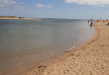
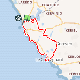
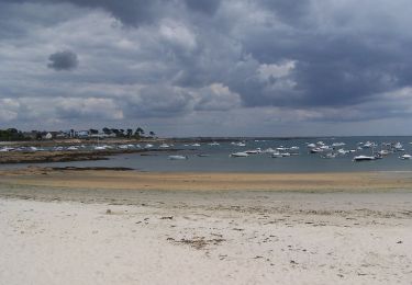
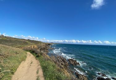
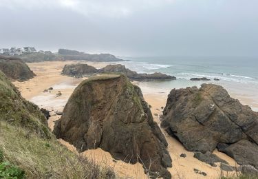
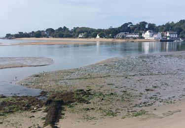
Randonnée Marche de 12,2 km à découvrir à Bretagne, Morbihan, Plœmeur. Cette randonnée est proposée par tracegps.
Description
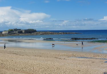
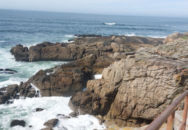
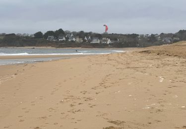
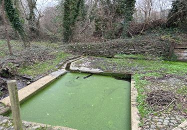
Ce circuit se trouve sur la commune de Ploemeur. Parking sur la droite quand vous venez de Guidel près du poste de secours. Pour démarrer la randonnée revenez sur vos pas au premier passage piéton vous traversez et vous rentrez dans les dunes, les habitations sur votre droite. Puis longez le plan d'eau de Lannenec. A saint Adrien suivre le balisage, passer près du lavoir et retrouver le plan d'eau. Bien plus loin vous allez traverser le site des Kaolins. Ensuite vous passerez la chapelle de saint Léonard. Continuez jusqu'au Corrigant où vous traverserez la route, continuez en face, prenez le petit escalier et revenez par le chemin côtier. Bonne balade.
Localisation
Commentaires
Randonnées à proximité
![Randonnée A pied Plœmeur - De la côte bleue aux collines blanches - Photo](https://media.geolcdn.com/t/375/260/b1cbbfe3-b17d-4626-90da-fc66faf0ad01.jpeg&format=jpg&maxdim=2)
![A pied A pied](https://static1.geolcdn.com/sitytour/trail-icons/100.png)
A pied
![](/images/other/stat-length.png)
![](https://static1.geolcdn.com/siteimages/upload/files/16400158638029165_repeat_loop_refresh_sync_direction_icon.png)
![Randonnée Marche Clohars-Carnoët - Le Pouldu - Photo](https://media.geolcdn.com/t/375/260/1a38db66-97d5-4b5b-9eac-2a7eff6538ed.jpg&format=jpg&maxdim=2)
![Marche Marche](https://static1.geolcdn.com/sitytour/trail-icons/101.png)
![Randonnée Marche Guidel - PR_56_Guidel_CA_03_Circuit3a_Autour-De-L-Etang-De-Lannenec_20240428 - Photo](https://media.geolcdn.com/t/375/260/6e0f082b-d9fc-4937-a2ef-b1992f251e56.jpg&format=jpg&maxdim=2)
![Marche Marche](https://static1.geolcdn.com/sitytour/trail-icons/101.png)
Marche
![](/images/other/stat-length.png)
![](https://static1.geolcdn.com/siteimages/upload/files/16400158638029165_repeat_loop_refresh_sync_direction_icon.png)
![Randonnée Marche Plœmeur - PR_56_Ploemeur_AA_01_Circuit3a_Des-Sables_20240413 - Photo](https://media.geolcdn.com/t/375/260/098300ee-8857-4731-b3c5-e3bdc7128025.jpg&format=jpg&maxdim=2)
![Marche Marche](https://static1.geolcdn.com/sitytour/trail-icons/101.png)
Marche
![](/images/other/stat-length.png)
![](https://static1.geolcdn.com/siteimages/upload/files/16400158638029165_repeat_loop_refresh_sync_direction_icon.png)
![Randonnée Marche Guidel - Guidel plage 7,6 km - Photo](https://media.geolcdn.com/t/375/260/ea313e26-3f1c-4186-89bc-ac39bff3fa8a.jpg&format=jpg&maxdim=2)
![Marche Marche](https://static1.geolcdn.com/sitytour/trail-icons/101.png)
Marche
![](/images/other/stat-length.png)
![](https://static1.geolcdn.com/siteimages/upload/files/16400158638029165_repeat_loop_refresh_sync_direction_icon.png)
![Randonnée Marche Clohars-Carnoët - Pouldu port peintres 6,3 km - Photo](https://media.geolcdn.com/t/375/260/d878685e-3577-4835-a424-00b6066e1383.jpg&format=jpg&maxdim=2)
![Marche Marche](https://static1.geolcdn.com/sitytour/trail-icons/101.png)
Marche
![](/images/other/stat-length.png)
![](https://static1.geolcdn.com/siteimages/upload/files/16400158638029165_repeat_loop_refresh_sync_direction_icon.png)
![Randonnée Marche Clohars-Carnoët - Pouldu Roche Percée et retour 9,5 km - Photo](https://media.geolcdn.com/t/375/260/9c185896-328f-4e1d-8063-56e555ea4d34.jpg&format=jpg&maxdim=2)
![Marche Marche](https://static1.geolcdn.com/sitytour/trail-icons/101.png)
Marche
![](/images/other/stat-length.png)
![](https://static1.geolcdn.com/siteimages/upload/files/16400158638029165_repeat_loop_refresh_sync_direction_icon.png)
![Randonnée Marche Guidel - PR_56_Guidel_BA_02_Circuit3b_Entre-Loch-Et-Laita_20231004 - Photo](https://media.geolcdn.com/t/375/260/c4260127-a5b9-4007-9324-09ddf3ba24ca.jpg&format=jpg&maxdim=2)
![Marche Marche](https://static1.geolcdn.com/sitytour/trail-icons/101.png)
Marche
![](/images/other/stat-length.png)
![](https://static1.geolcdn.com/siteimages/upload/files/16400158638029165_repeat_loop_refresh_sync_direction_icon.png)
![Randonnée Marche Guidel - laita - Photo](https://media.geolcdn.com/t/375/260/d2fc7529-c784-40ff-828a-4079bf6b08e9.jpg&format=jpg&maxdim=2)
![Marche Marche](https://static1.geolcdn.com/sitytour/trail-icons/101.png)