![](/images/other/stat-length.png)
![Randonnée V.T.T. Saint-Léonard-des-Bois - Espace VTT FFC des Alpes Mancelles - Le Val - Balisage n°6 - Photo](https://media.geolcdn.com/t/1900/400/ext.pjpeg?maxdim=2&url=https%3A%2F%2Fservices.sitytrail.com%2FGeolivesWS%2FDownloadMedia.ashx%3FTrailID%3D105107%26Media%3D8702_2.jpg)
Espace VTT FFC des Alpes Mancelles - Le Val - Balisage n°6
tracegps
Utilisateur
![Longueur](/images/other/stat-length.png)
![Altitude max](https://static1.geolcdn.com/siteimages/upload/files/1508320355ic_sort_altitude_max_24dp.png)
![Dénivelé positif](https://static1.geolcdn.com/siteimages/upload/files/1508320355ic_sort_den_pos_24dp.png)
![Km-Effort](/images/other/stat-length.png)
![Altitude min](https://static1.geolcdn.com/siteimages/upload/files/1508320355ic_sort_altitude_min_24dp.png)
![Dénivelé négatif](https://static1.geolcdn.com/siteimages/upload/files/1508320355ic_sort_den_neg_24dp.png)
![Boucle](https://static1.geolcdn.com/siteimages/upload/files/16400158638029165_repeat_loop_refresh_sync_direction_icon.png)
![V.T.T.](https://static1.geolcdn.com/sitytour/trail-icons/202.png)
34m
Difficulté : Moyen
![Scannez ce code QR pour ouvrir la randonnée dans l'application SityTrail](https://capi.geolives.com/qq0zvz2zws4bq2lad0pu/sitytour/trails/105107/qr.png?size=200)
Application GPS de randonnée GRATUITE
À propos
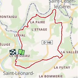
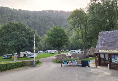
Randonnée V.T.T. de 8,5 km à découvrir à Pays de la Loire, Sarthe, Saint-Léonard-des-Bois. Cette randonnée est proposée par tracegps.
Description
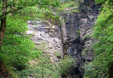
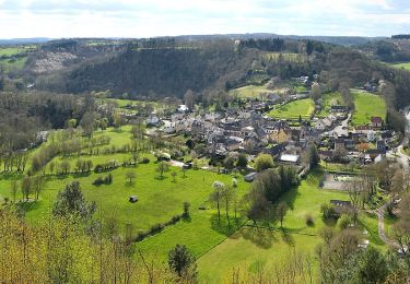
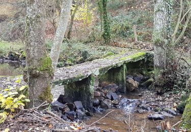
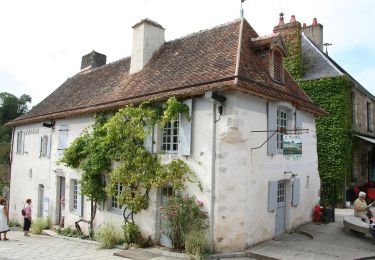
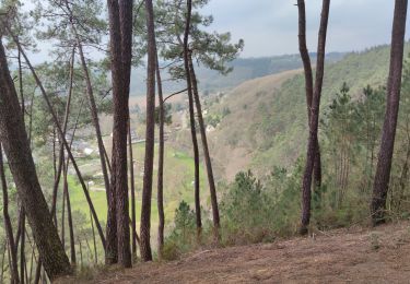
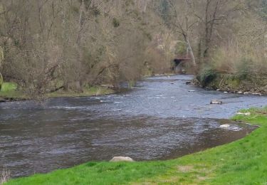
Cette petite boucle entre Saint Léonard des Bois et Saint Cénéri le Gérei débute par une montée assez raide jusqu'à un magnifique point de vue sur Saint Léonard des Bois. Ensuite, c'est plus plat et assez roulant. De beaux chemins avec des parties assez techniques. Cette boucle peut aussi se faire à partir de Saint Cénéri le Gérei qui est un très joli village avec son église perchée sur un éperon rocheux dominant la Sarthe. Commentaire et tracé réalisé sur le terrain par Guillaume61. Merci à lui !
Localisation
Commentaires
Randonnées à proximité
![Randonnée V.T.T. Saint-Léonard-des-Bois - Espace VTT FFC des Alpes Mancelles - Les Buttes - Balisage n°5 - Photo](https://media.geolcdn.com/t/375/260/ext.jpg?maxdim=2&url=https%3A%2F%2Fservices.sitytrail.com%2FGeolivesWS%2FDownloadMedia.ashx%3FTrailID%3D105108%26Media%3D8706_1.jpg)
![V.T.T. V.T.T.](https://static1.geolcdn.com/sitytour/trail-icons/202.png)
V.T.T.
![](/images/other/stat-length.png)
![](https://static1.geolcdn.com/siteimages/upload/files/16400158638029165_repeat_loop_refresh_sync_direction_icon.png)
![Randonnée Marche Saint-Léonard-des-Bois - St Léonard Narbonne 10km - Photo](https://media.geolcdn.com/t/375/260/ext.jpg?maxdim=2&url=https%3A%2F%2Fstatic1.geolcdn.com%2Fsiteimages%2Fupload%2Ffiles%2F1553511878bg_sport_marche.png)
![Marche Marche](https://static1.geolcdn.com/sitytour/trail-icons/101.png)
Marche
![](/images/other/stat-length.png)
![](https://static1.geolcdn.com/siteimages/upload/files/16400158638029165_repeat_loop_refresh_sync_direction_icon.png)
![Randonnée A pied Saint-Paul-le-Gaultier - Le Bois de Chemasson - Photo](https://media.geolcdn.com/t/375/260/ff95c566-5307-4d11-b561-b3411b7fcbe5.jpeg&format=jpg&maxdim=2)
![A pied A pied](https://static1.geolcdn.com/sitytour/trail-icons/100.png)
A pied
![](/images/other/stat-length.png)
![](https://static1.geolcdn.com/siteimages/upload/files/16400158638029165_repeat_loop_refresh_sync_direction_icon.png)
![Randonnée A pied Saint-Léonard-des-Bois - Vallée de Misère - Photo](https://media.geolcdn.com/t/375/260/7fc7be85-cc05-431c-a859-1b7cad4d3195.jpeg&format=jpg&maxdim=2)
![A pied A pied](https://static1.geolcdn.com/sitytour/trail-icons/100.png)
A pied
![](/images/other/stat-length.png)
![](https://static1.geolcdn.com/siteimages/upload/files/16400158638029165_repeat_loop_refresh_sync_direction_icon.png)
![Randonnée A pied Saint-Pierre-des-Nids - Boucle du Moulin de Campas - Photo](https://media.geolcdn.com/t/375/260/98d53c49-9a56-4f6a-b411-1cf56960c8d1.jpeg&format=jpg&maxdim=2)
![A pied A pied](https://static1.geolcdn.com/sitytour/trail-icons/100.png)
A pied
![](/images/other/stat-length.png)
![](https://static1.geolcdn.com/siteimages/upload/files/16400158638029165_repeat_loop_refresh_sync_direction_icon.png)
![Randonnée A pied Saint-Léonard-des-Bois - Les méandres de la Sarthe - Photo](https://media.geolcdn.com/t/375/260/59495368-fec3-427c-ab17-f336a308f404.jpeg&format=jpg&maxdim=2)
![A pied A pied](https://static1.geolcdn.com/sitytour/trail-icons/100.png)
A pied
![](/images/other/stat-length.png)
![](https://static1.geolcdn.com/siteimages/upload/files/16400158638029165_repeat_loop_refresh_sync_direction_icon.png)
![Randonnée Marche Saint-Léonard-des-Bois - 4 = St Léonard des bois - Mont St Jean - Photo](https://media.geolcdn.com/t/375/260/f028599f-c77e-4b20-be32-2c2027f75247.jpg&format=jpg&maxdim=2)
![Marche Marche](https://static1.geolcdn.com/sitytour/trail-icons/101.png)
Marche
![](/images/other/stat-length.png)
![](https://static1.geolcdn.com/siteimages/upload/files/16400158638029165_repeat_loop_refresh_sync_direction_icon.png)
![Randonnée Marche Saint-Léonard-des-Bois - Saint Léonard des Bois - 30 mars 2022 - Photo](https://media.geolcdn.com/t/375/260/4e99ac1e-3e54-4b5b-8c44-bbd31402c1a6.jpg&format=jpg&maxdim=2)
![Marche Marche](https://static1.geolcdn.com/sitytour/trail-icons/101.png)
Marche
![](/images/other/stat-length.png)
![](https://static1.geolcdn.com/siteimages/upload/files/16400158638029165_repeat_loop_refresh_sync_direction_icon.png)
![Randonnée Marche Saint-Léonard-des-Bois - Saint Léonard des Bois - Photo](https://media.geolcdn.com/t/375/260/4e91d3f9-5d7e-4e92-8c1c-e6064c350a4e.jpg&format=jpg&maxdim=2)
![Marche Marche](https://static1.geolcdn.com/sitytour/trail-icons/101.png)
Marche
![](/images/other/stat-length.png)
![](https://static1.geolcdn.com/siteimages/upload/files/16400158638029165_repeat_loop_refresh_sync_direction_icon.png)
Très bonne rando, super paysages, assez technique par endroits, ça monte ça descend assez raide parfois !A faire en complément du balisage n°5 pour faire un bon tour autour de Saint Léonard des bois.Tout le parcours est balisé (site VTT FFC du domaine du gasseau)