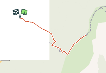
![](/images/other/stat-length.png)
![Randonnée Marche Pommerol - Col de La Fromagère - Le Fourchat - Photo](https://media.geolcdn.com/t/1900/400/ext.pjpeg?maxdim=2&url=https%3A%2F%2Fservices.sitytrail.com%2FGeolivesWS%2FDownloadMedia.ashx%3FTrailID%3D105097%26Media%3D8690_3.jpg)
Col de La Fromagère - Le Fourchat
tracegps
Utilisateur
![Longueur](/images/other/stat-length.png)
![Altitude max](https://static1.geolcdn.com/siteimages/upload/files/1508320355ic_sort_altitude_max_24dp.png)
![Dénivelé positif](https://static1.geolcdn.com/siteimages/upload/files/1508320355ic_sort_den_pos_24dp.png)
![Km-Effort](/images/other/stat-length.png)
![Altitude min](https://static1.geolcdn.com/siteimages/upload/files/1508320355ic_sort_altitude_min_24dp.png)
![Dénivelé négatif](https://static1.geolcdn.com/siteimages/upload/files/1508320355ic_sort_den_neg_24dp.png)
![Boucle](https://static1.geolcdn.com/siteimages/upload/files/16400158638029165_repeat_loop_refresh_sync_direction_icon.png)
![Marche](https://static1.geolcdn.com/sitytour/trail-icons/101.png)
2h30
Difficulté : Difficile
![Scannez ce code QR pour ouvrir la randonnée dans l'application SityTrail](https://capi.geolives.com/qq0zvz2zws4bq2lad0pu/sitytour/trails/105097/qr.png?size=200)
Application GPS de randonnée GRATUITE
À propos
Randonnée Marche de 4,5 km à découvrir à Auvergne-Rhône-Alpes, Drôme, Pommerol. Cette randonnée est proposée par tracegps.
Description
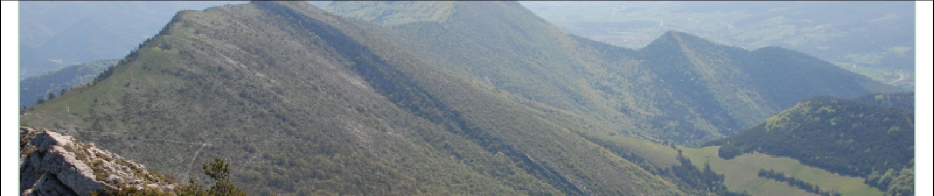
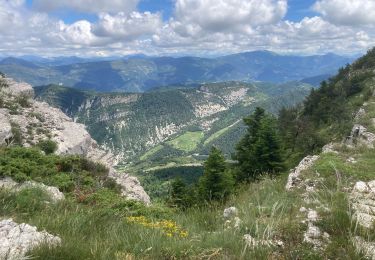
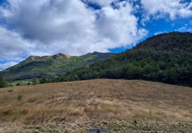
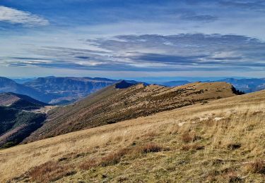
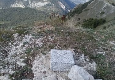
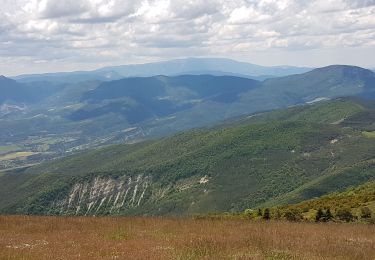
Une rando courte mais qui grimpe très fort. Début du col de la Fromagère au dessus de Rosans à 1075 m et arrivée au sommet du Fourchat à 1571 m. Du col prendre la route qui grimpe à droite en venant de Rosans. Suivre cette route tous le long jusqu'à un poteau indicateur "Le Fourchat". Prendre le chemin qui sort de la forêt et grimpe à flanc de montagne. Arrivé au premier mamelon, le sommet est atteint en suivant le ligne des crêtes assez impressionnante, d'un côté la falaise et de l'autre une forte pente; sujet au vertige s'abstenir. Le retour se fait par le même chemin. Au sommet panorama à 180 ° magnifique.
Localisation
Commentaires
Randonnées à proximité
![Randonnée Marche nordique Rosans - Crêtes du raton à partir du col de Pommerol - Photo](https://media.geolcdn.com/t/375/260/ce74893b-bcd8-461a-8afe-7c5344df54b3.jpg&format=jpg&maxdim=2)
![Marche nordique Marche nordique](https://static1.geolcdn.com/sitytour/trail-icons/102.png)
Marche nordique
![](/images/other/stat-length.png)
![](https://static1.geolcdn.com/siteimages/upload/files/16400158638029165_repeat_loop_refresh_sync_direction_icon.png)
![Randonnée Marche Rosans - Le Fourchat - Photo](https://media.geolcdn.com/t/375/260/7f174db1-94bf-4048-baf9-e56696ece47f.jpg&format=jpg&maxdim=2)
![Marche Marche](https://static1.geolcdn.com/sitytour/trail-icons/101.png)
Marche
![](/images/other/stat-length.png)
![](https://static1.geolcdn.com/siteimages/upload/files/16400158638029165_repeat_loop_refresh_sync_direction_icon.png)
![Randonnée Marche Rosans - Crête de Raton Via Raton - Photo](https://media.geolcdn.com/t/375/260/3e9ccc6f-4f06-44dd-9d37-5eaabb2c9ea0.jpg&format=jpg&maxdim=2)
![Marche Marche](https://static1.geolcdn.com/sitytour/trail-icons/101.png)
Marche
![](/images/other/stat-length.png)
![](https://static1.geolcdn.com/siteimages/upload/files/16400158638029165_repeat_loop_refresh_sync_direction_icon.png)
![Randonnée Marche Rosans - 7km Fourchat AR par chemin du facteur (partie) - Photo](https://media.geolcdn.com/t/375/260/18cea4ea-f64c-464e-b93c-f5601bfe95d1.jpg&format=jpg&maxdim=2)
![Marche Marche](https://static1.geolcdn.com/sitytour/trail-icons/101.png)
Marche
![](/images/other/stat-length.png)
![](https://static1.geolcdn.com/siteimages/upload/files/16400158638029165_repeat_loop_refresh_sync_direction_icon.png)
![Randonnée Marche Rosans - Le Fourchat par le col de Pommerol - Photo](https://media.geolcdn.com/t/375/260/cfab902e-83fa-4d54-aaa2-8926b38ea959.jpg&format=jpg&maxdim=2)
![Marche Marche](https://static1.geolcdn.com/sitytour/trail-icons/101.png)
Marche
![](/images/other/stat-length.png)
![](https://static1.geolcdn.com/siteimages/upload/files/16400158638029165_repeat_loop_refresh_sync_direction_icon.png)
![Randonnée Vélo de route La Charce - 75km VC La Charce Montmorin Serres Carabès Valdrôme La Chance - Photo](https://media.geolcdn.com/t/375/260/ext.jpg?maxdim=2&url=https%3A%2F%2Fstatic1.geolcdn.com%2Fsiteimages%2Fupload%2Ffiles%2F1524743154velo.jpg)
![Vélo de route Vélo de route](https://static1.geolcdn.com/sitytour/trail-icons/201.png)
Vélo de route
![](/images/other/stat-length.png)
![](https://static1.geolcdn.com/siteimages/upload/files/16400158638029165_repeat_loop_refresh_sync_direction_icon.png)
![Randonnée Marche Rosans - Montagne de Raton au départ du col de Pommerol ou de la Fromagère - Photo](https://media.geolcdn.com/t/375/260/88563a29-0d69-4d1d-a9a8-ed2b63e53039.jpg&format=jpg&maxdim=2)
![Marche Marche](https://static1.geolcdn.com/sitytour/trail-icons/101.png)
Marche
![](/images/other/stat-length.png)
![](https://static1.geolcdn.com/siteimages/upload/files/16400158638029165_repeat_loop_refresh_sync_direction_icon.png)
![Randonnée Marche Rosans - POMMEROL - LA MONTAGNE DE RATON - Photo](https://media.geolcdn.com/t/375/260/904beef7-15df-4454-b310-e33a491109ff.jpg&format=jpg&maxdim=2)
![Marche Marche](https://static1.geolcdn.com/sitytour/trail-icons/101.png)
Marche
![](/images/other/stat-length.png)
![](https://static1.geolcdn.com/siteimages/upload/files/16400158638029165_repeat_loop_refresh_sync_direction_icon.png)
![Randonnée V.T.T. Rosans - HA J2 long - Photo](https://media.geolcdn.com/t/375/260/ext.jpg?maxdim=2&url=https%3A%2F%2Fstatic1.geolcdn.com%2Fsiteimages%2Fupload%2Ffiles%2F1524743154velo.jpg)
![V.T.T. V.T.T.](https://static1.geolcdn.com/sitytour/trail-icons/202.png)
V.T.T.
![](/images/other/stat-length.png)
![](https://static1.geolcdn.com/siteimages/upload/files/16400158638029165_repeat_loop_refresh_sync_direction_icon.png)