![](/images/other/stat-length.png)
![Randonnée Course à pied Lesneven - Lesneven boucle 4 - Photo](https://media.geolcdn.com/t/1900/400/ext.pjpeg?maxdim=2&url=https%3A%2F%2Fstatic1.geolcdn.com%2Fsiteimages%2Fupload%2Ffiles%2F1524743154running.jpg)
Lesneven boucle 4
tracegps
Utilisateur
![Longueur](/images/other/stat-length.png)
Longueur
8,1 km
![Altitude max](https://static1.geolcdn.com/siteimages/upload/files/1508320355ic_sort_altitude_max_24dp.png)
Altitude max
81 m
![Dénivelé positif](https://static1.geolcdn.com/siteimages/upload/files/1508320355ic_sort_den_pos_24dp.png)
Dénivelé positif
53 m
![Km-Effort](/images/other/stat-length.png)
Km-Effort
8,8 km
![Altitude min](https://static1.geolcdn.com/siteimages/upload/files/1508320355ic_sort_altitude_min_24dp.png)
Altitude min
52 m
![Dénivelé négatif](https://static1.geolcdn.com/siteimages/upload/files/1508320355ic_sort_den_neg_24dp.png)
Dénivelé négatif
53 m
![Boucle](https://static1.geolcdn.com/siteimages/upload/files/16400158638029165_repeat_loop_refresh_sync_direction_icon.png)
Boucle
Oui
Date de création :
2014-12-10 00:00:00.0
Dernière modification :
2014-12-10 00:00:00.0
![Course à pied](https://static1.geolcdn.com/sitytour/trail-icons/103.png)
1h00
Difficulté : Moyen
![Scannez ce code QR pour ouvrir la randonnée dans l'application SityTrail](https://capi.geolives.com/qq0zvz2zws4bq2lad0pu/sitytour/trails/105071/qr.png?size=200)
Application GPS de randonnée GRATUITE
À propos
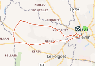
Randonnée Course à pied de 8,1 km à découvrir à Bretagne, Finistère, Lesneven. Cette randonnée est proposée par tracegps.
Description
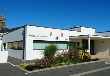
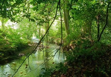
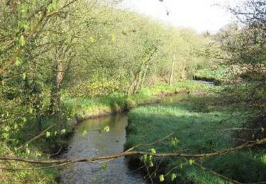
Depuis la place du Maréchal Foch de Lesneven direction la rue St Anne pour rejoindre le complexe Saint-Exupéry puis la campagne bocagère avant le retour par des chemins vicinaux.
Localisation
Pays :
France
Région :
Bretagne
Département/Province :
Finistère
Commune :
Lesneven
Localité :
Unknown
Départ:(Dec)
Départ:(UTM)
402366 ; 5380828 (30U) N.
Commentaires
Randonnées à proximité
![Randonnée Marche nordique Le Drennec - le drennec Loc brevelaire - Photo](https://media.geolcdn.com/t/375/260/ab9b6792-4dee-4bbb-bccb-494bcc9e5ee2.jpg&format=jpg&maxdim=2)
![Marche nordique Marche nordique](https://static1.geolcdn.com/sitytour/trail-icons/102.png)
le drennec Loc brevelaire
Marche nordique
Très facile
Le Drennec,
Bretagne,
Finistère,
France
![](/images/other/stat-length.png)
13 km | 14,6 km-effort
2h 48min
![](https://static1.geolcdn.com/siteimages/upload/files/16400158638029165_repeat_loop_refresh_sync_direction_icon.png)
Oui
![Randonnée Marche nordique Saint-Méen - st méen - Photo](https://media.geolcdn.com/t/375/260/053ac6aa-b95e-4a19-92c5-ec066113aa0b.jpg&format=jpg&maxdim=2)
![Marche nordique Marche nordique](https://static1.geolcdn.com/sitytour/trail-icons/102.png)
st méen
Marche nordique
Très facile
Saint-Méen,
Bretagne,
Finistère,
France
![](/images/other/stat-length.png)
14,9 km | 17,2 km-effort
2h 57min
![](https://static1.geolcdn.com/siteimages/upload/files/16400158638029165_repeat_loop_refresh_sync_direction_icon.png)
Oui
![Randonnée A pied Lanarvily - Boucle du Pays de Lesneven - Photo](https://media.geolcdn.com/t/375/260/eeb804c4-01ae-4c34-86e2-cd1b3e03bef7.jpeg&format=jpg&maxdim=2)
![A pied A pied](https://static1.geolcdn.com/sitytour/trail-icons/100.png)
Boucle du Pays de Lesneven
A pied
Facile
Lanarvily,
Bretagne,
Finistère,
France
![](/images/other/stat-length.png)
5,7 km | 6,9 km-effort
1h 34min
![](https://static1.geolcdn.com/siteimages/upload/files/16400158638029165_repeat_loop_refresh_sync_direction_icon.png)
Non
![Randonnée A pied Plouider - Poul Sant Dider - Photo](https://media.geolcdn.com/t/375/260/66d4aee4-cd7f-42c9-b6ca-da83a1ae6e61.jpeg&format=jpg&maxdim=2)
![A pied A pied](https://static1.geolcdn.com/sitytour/trail-icons/100.png)
Poul Sant Dider
A pied
Facile
Plouider,
Bretagne,
Finistère,
France
![](/images/other/stat-length.png)
6,3 km | 7,4 km-effort
1h 41min
![](https://static1.geolcdn.com/siteimages/upload/files/16400158638029165_repeat_loop_refresh_sync_direction_icon.png)
Oui
![Randonnée Marche nordique Le Drennec - le drenec. Loc brevelaire - Photo](https://media.geolcdn.com/t/375/260/740b1ba6-50e9-4a18-8c3b-78b478faa9f7.jpg&format=jpg&maxdim=2)
![Marche nordique Marche nordique](https://static1.geolcdn.com/sitytour/trail-icons/102.png)
le drenec. Loc brevelaire
Marche nordique
Très facile
Le Drennec,
Bretagne,
Finistère,
France
![](/images/other/stat-length.png)
17,6 km | 21 km-effort
3h 43min
![](https://static1.geolcdn.com/siteimages/upload/files/16400158638029165_repeat_loop_refresh_sync_direction_icon.png)
Oui
![Randonnée Marche Le Drennec - De Le Drennec à Lannilis le long de l'Aber Wrac'h - Photo](https://media.geolcdn.com/t/375/260/ext.jpg?maxdim=2&url=https%3A%2F%2Fservices.sitytrail.com%2FGeolivesWS%2FDownloadMedia.ashx%3FTrailID%3D109179%26Media%3D3222_1.jpg)
![Marche Marche](https://static1.geolcdn.com/sitytour/trail-icons/101.png)
De Le Drennec à Lannilis le long de l'Aber Wrac'h
Marche
Difficile
(1)
Le Drennec,
Bretagne,
Finistère,
France
![](/images/other/stat-length.png)
19,4 km | 24 km-effort
4h 30min
![](https://static1.geolcdn.com/siteimages/upload/files/16400158638029165_repeat_loop_refresh_sync_direction_icon.png)
Non
![Randonnée Marche Kernouës - kernoues - Photo](https://media.geolcdn.com/t/375/260/f29b426d-e429-43f3-9cb7-94a586858472.jpg&format=jpg&maxdim=2)
![Marche Marche](https://static1.geolcdn.com/sitytour/trail-icons/101.png)
![Randonnée Marche Plouider - De Pont du Chatel à Treflez par la chapelle de Santez Ventroc - Photo](https://media.geolcdn.com/t/375/260/ext.jpg?maxdim=2&url=https%3A%2F%2Fstatic1.geolcdn.com%2Fsiteimages%2Fupload%2Ffiles%2F1553511878bg_sport_marche.png)
![Marche Marche](https://static1.geolcdn.com/sitytour/trail-icons/101.png)
De Pont du Chatel à Treflez par la chapelle de Santez Ventroc
Marche
Difficile
Plouider,
Bretagne,
Finistère,
France
![](/images/other/stat-length.png)
20 km | 23 km-effort
5h 0min
![](https://static1.geolcdn.com/siteimages/upload/files/16400158638029165_repeat_loop_refresh_sync_direction_icon.png)
Oui
![Randonnée V.T.T. Lesneven - Lesneven boucle 4 - Photo](https://media.geolcdn.com/t/375/260/ext.jpg?maxdim=2&url=https%3A%2F%2Fstatic1.geolcdn.com%2Fsiteimages%2Fupload%2Ffiles%2F1524743154velo.jpg)
![V.T.T. V.T.T.](https://static1.geolcdn.com/sitytour/trail-icons/202.png)
Lesneven boucle 4
V.T.T.
Facile
Lesneven,
Bretagne,
Finistère,
France
![](/images/other/stat-length.png)
8,1 km | 8,8 km-effort
30min
![](https://static1.geolcdn.com/siteimages/upload/files/16400158638029165_repeat_loop_refresh_sync_direction_icon.png)
Oui