![](/images/other/stat-length.png)
![Randonnée Marche Cahors - Cahors, le Lot, le causse, la vieille ville - Photo](https://media.geolcdn.com/t/1900/400/ext.pjpeg?maxdim=2&url=https%3A%2F%2Fservices.sitytrail.com%2FGeolivesWS%2FDownloadMedia.ashx%3FTrailID%3D105049%26Media%3D8630_4.jpg)
Cahors, le Lot, le causse, la vieille ville
tracegps
Utilisateur
![Longueur](/images/other/stat-length.png)
![Altitude max](https://static1.geolcdn.com/siteimages/upload/files/1508320355ic_sort_altitude_max_24dp.png)
![Dénivelé positif](https://static1.geolcdn.com/siteimages/upload/files/1508320355ic_sort_den_pos_24dp.png)
![Km-Effort](/images/other/stat-length.png)
![Altitude min](https://static1.geolcdn.com/siteimages/upload/files/1508320355ic_sort_altitude_min_24dp.png)
![Dénivelé négatif](https://static1.geolcdn.com/siteimages/upload/files/1508320355ic_sort_den_neg_24dp.png)
![Boucle](https://static1.geolcdn.com/siteimages/upload/files/16400158638029165_repeat_loop_refresh_sync_direction_icon.png)
![Marche](https://static1.geolcdn.com/sitytour/trail-icons/101.png)
1h30
Difficulté : Moyen
![Scannez ce code QR pour ouvrir la randonnée dans l'application SityTrail](https://capi.geolives.com/qq0zvz2zws4bq2lad0pu/sitytour/trails/105049/qr.png?size=200)
Application GPS de randonnée GRATUITE
À propos
Randonnée Marche de 7,3 km à découvrir à Occitanie, Lot, Cahors. Cette randonnée est proposée par tracegps.
Description
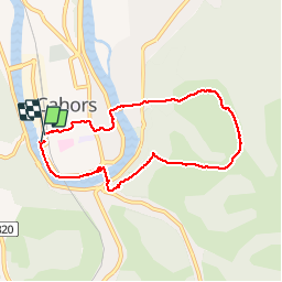
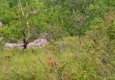
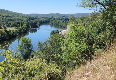
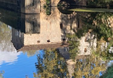
Le circuit débute au Pont Valentré. Il suit le Lot par un joli chemin piéton aménagé au bord de l'eau (quelques centaines de mètres après le pont Valentré, au niveau de la buvette, descendre au bord de l'eau). Le Lot est traversé au pont suivant, le pont Louis Philippe. Un chemin dans un maquis sauvage s'élève jusqu'au mont Saint Cyr par une pente assez raide ( GR ). Magnifique panorama sur le Lot et la ville. On contourne un vallon en restant sur le causse, avant de redescendre sur le Lot, avec de nouveau de magnifiques points de vue sur la ville (balisage jaune). On traverse à nouveau le Lot et l'on rejoint le Pont Valentré à travers les ruelles de la vielle ville, sans oublier de se réhydrater à une des terrasses ensoleillées. Une vision différente, un peu sportive, de Cahors.
Localisation
Commentaires
Randonnées à proximité
![Randonnée V.T.T. Cahors - Cahors-La Rozière 2005 - Photo](https://media.geolcdn.com/t/375/260/ext.jpg?maxdim=2&url=https%3A%2F%2Fservices.sitytrail.com%2FGeolivesWS%2FDownloadMedia.ashx%3FTrailID%3D100852%26Media%3D349_3.jpg)
![V.T.T. V.T.T.](https://static1.geolcdn.com/sitytour/trail-icons/202.png)
V.T.T.
![](/images/other/stat-length.png)
![](https://static1.geolcdn.com/siteimages/upload/files/16400158638029165_repeat_loop_refresh_sync_direction_icon.png)
![Randonnée Marche Pradines - Cahors les Durands 7km - Photo](https://media.geolcdn.com/t/375/260/b499c06a-31dd-4c33-ac8e-a7a08d8f73b9.jpg&format=jpg&maxdim=2)
![Marche Marche](https://static1.geolcdn.com/sitytour/trail-icons/101.png)
Marche
![](/images/other/stat-length.png)
![](https://static1.geolcdn.com/siteimages/upload/files/16400158638029165_repeat_loop_refresh_sync_direction_icon.png)
![Randonnée V.T.T. Lamagdelaine - lamagdelaine, vers - Photo](https://media.geolcdn.com/t/375/260/283c2e24-a254-41e5-9434-72402b6820e6.jpg&format=jpg&maxdim=2)
![V.T.T. V.T.T.](https://static1.geolcdn.com/sitytour/trail-icons/202.png)
V.T.T.
![](/images/other/stat-length.png)
![](https://static1.geolcdn.com/siteimages/upload/files/16400158638029165_repeat_loop_refresh_sync_direction_icon.png)
![Randonnée Marche nordique Pradines - 15km chemin des combettes - Photo](https://media.geolcdn.com/t/375/260/ext.jpg?maxdim=2&url=https%3A%2F%2Fstatic1.geolcdn.com%2Fsiteimages%2Fupload%2Ffiles%2F1545311037marcheuse_200dpi.jpg)
![Marche nordique Marche nordique](https://static1.geolcdn.com/sitytour/trail-icons/102.png)
Marche nordique
![](/images/other/stat-length.png)
![](https://static1.geolcdn.com/siteimages/upload/files/16400158638029165_repeat_loop_refresh_sync_direction_icon.png)
![Randonnée Marche Bellefont-La Rauze - Larroque des arcs constant valroufie - Photo](https://media.geolcdn.com/t/375/260/a8782ff0-12cf-4933-a6da-7fde2ecf71ff.jpg&format=jpg&maxdim=2)
![Marche Marche](https://static1.geolcdn.com/sitytour/trail-icons/101.png)
Marche
![](/images/other/stat-length.png)
![](https://static1.geolcdn.com/siteimages/upload/files/16400158638029165_repeat_loop_refresh_sync_direction_icon.png)
![Randonnée Marche Cahors - Croix magne - Photo](https://media.geolcdn.com/t/375/260/cc85df98-5a2e-43d8-bf1a-7dfe3348151d.jpg&format=jpg&maxdim=2)
![Marche Marche](https://static1.geolcdn.com/sitytour/trail-icons/101.png)
![Randonnée Marche Cahors - Étape Cahors Lascabannes - Photo](https://media.geolcdn.com/t/375/260/e86b613e-64bd-42e2-b94b-341bc6634d94.jpg&format=jpg&maxdim=2)
![Marche Marche](https://static1.geolcdn.com/sitytour/trail-icons/101.png)
Marche
![](/images/other/stat-length.png)
![](https://static1.geolcdn.com/siteimages/upload/files/16400158638029165_repeat_loop_refresh_sync_direction_icon.png)
![Marche Marche](https://static1.geolcdn.com/sitytour/trail-icons/101.png)
Marche
![](/images/other/stat-length.png)
![](https://static1.geolcdn.com/siteimages/upload/files/16400158638029165_repeat_loop_refresh_sync_direction_icon.png)
![Randonnée V.T.T. Trespoux-Rassiels - Circuit ouest de Trespoux Rassiels - Photo](https://media.geolcdn.com/t/375/260/ext.jpg?maxdim=2&url=https%3A%2F%2Fservices.sitytrail.com%2FGeolivesWS%2FDownloadMedia.ashx%3FTrailID%3D191586%26Media%3D15215_3.jpg)
![V.T.T. V.T.T.](https://static1.geolcdn.com/sitytour/trail-icons/202.png)
V.T.T.
![](/images/other/stat-length.png)
![](https://static1.geolcdn.com/siteimages/upload/files/16400158638029165_repeat_loop_refresh_sync_direction_icon.png)