![](/images/other/stat-length.png)
![Randonnée V.T.T. Lesneven - Lesneven boucle 1 - Photo](https://media.geolcdn.com/t/1900/400/ext.pjpeg?maxdim=2&url=https%3A%2F%2Fstatic1.geolcdn.com%2Fsiteimages%2Fupload%2Ffiles%2F1524743154velo.jpg)
Lesneven boucle 1
tracegps
Utilisateur
![Longueur](/images/other/stat-length.png)
Longueur
6,3 km
![Altitude max](https://static1.geolcdn.com/siteimages/upload/files/1508320355ic_sort_altitude_max_24dp.png)
Altitude max
77 m
![Dénivelé positif](https://static1.geolcdn.com/siteimages/upload/files/1508320355ic_sort_den_pos_24dp.png)
Dénivelé positif
60 m
![Km-Effort](/images/other/stat-length.png)
Km-Effort
7,1 km
![Altitude min](https://static1.geolcdn.com/siteimages/upload/files/1508320355ic_sort_altitude_min_24dp.png)
Altitude min
32 m
![Dénivelé négatif](https://static1.geolcdn.com/siteimages/upload/files/1508320355ic_sort_den_neg_24dp.png)
Dénivelé négatif
59 m
![Boucle](https://static1.geolcdn.com/siteimages/upload/files/16400158638029165_repeat_loop_refresh_sync_direction_icon.png)
Boucle
Oui
Date de création :
2014-12-10 00:00:00.0
Dernière modification :
2014-12-10 00:00:00.0
![V.T.T.](https://static1.geolcdn.com/sitytour/trail-icons/202.png)
25m
Difficulté : Facile
![Scannez ce code QR pour ouvrir la randonnée dans l'application SityTrail](https://capi.geolives.com/qq0zvz2zws4bq2lad0pu/sitytour/trails/105014/qr.png?size=200)
Application GPS de randonnée GRATUITE
À propos
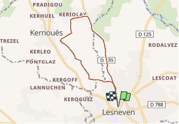
Randonnée V.T.T. de 6,3 km à découvrir à Bretagne, Finistère, Lesneven. Cette randonnée est proposée par tracegps.
Description
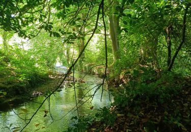
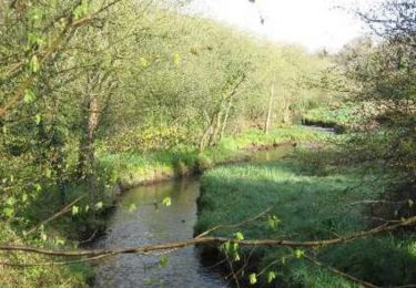
Depuis la place du Maréchal Foch de Lesneven, prendre la direction de la Côte des Légendes sur la rue du Four et RD puis bifurquer à gauche sur une VC au lieu dit Kergunic et retour vers le bourg de Lesneven au travers des chemins creux .
Localisation
Pays :
France
Région :
Bretagne
Département/Province :
Finistère
Commune :
Lesneven
Localité :
Unknown
Départ:(Dec)
Départ:(UTM)
402369 ; 5380834 (30U) N.
Commentaires
Randonnées à proximité
![Randonnée Marche nordique Le Drennec - le drennec Loc brevelaire - Photo](https://media.geolcdn.com/t/375/260/ab9b6792-4dee-4bbb-bccb-494bcc9e5ee2.jpg&format=jpg&maxdim=2)
![Marche nordique Marche nordique](https://static1.geolcdn.com/sitytour/trail-icons/102.png)
le drennec Loc brevelaire
Marche nordique
Très facile
Le Drennec,
Bretagne,
Finistère,
France
![](/images/other/stat-length.png)
13 km | 14,6 km-effort
2h 48min
![](https://static1.geolcdn.com/siteimages/upload/files/16400158638029165_repeat_loop_refresh_sync_direction_icon.png)
Oui
![Randonnée Marche nordique Saint-Méen - st méen - Photo](https://media.geolcdn.com/t/375/260/053ac6aa-b95e-4a19-92c5-ec066113aa0b.jpg&format=jpg&maxdim=2)
![Marche nordique Marche nordique](https://static1.geolcdn.com/sitytour/trail-icons/102.png)
st méen
Marche nordique
Très facile
Saint-Méen,
Bretagne,
Finistère,
France
![](/images/other/stat-length.png)
14,9 km | 17,2 km-effort
2h 57min
![](https://static1.geolcdn.com/siteimages/upload/files/16400158638029165_repeat_loop_refresh_sync_direction_icon.png)
Oui
![Randonnée A pied Lanarvily - Boucle du Pays de Lesneven - Photo](https://media.geolcdn.com/t/375/260/eeb804c4-01ae-4c34-86e2-cd1b3e03bef7.jpeg&format=jpg&maxdim=2)
![A pied A pied](https://static1.geolcdn.com/sitytour/trail-icons/100.png)
Boucle du Pays de Lesneven
A pied
Facile
Lanarvily,
Bretagne,
Finistère,
France
![](/images/other/stat-length.png)
5,7 km | 6,9 km-effort
1h 34min
![](https://static1.geolcdn.com/siteimages/upload/files/16400158638029165_repeat_loop_refresh_sync_direction_icon.png)
Non
![Randonnée A pied Plouider - Poul Sant Dider - Photo](https://media.geolcdn.com/t/375/260/66d4aee4-cd7f-42c9-b6ca-da83a1ae6e61.jpeg&format=jpg&maxdim=2)
![A pied A pied](https://static1.geolcdn.com/sitytour/trail-icons/100.png)
Poul Sant Dider
A pied
Facile
Plouider,
Bretagne,
Finistère,
France
![](/images/other/stat-length.png)
6,3 km | 7,4 km-effort
1h 41min
![](https://static1.geolcdn.com/siteimages/upload/files/16400158638029165_repeat_loop_refresh_sync_direction_icon.png)
Oui
![Randonnée Marche nordique Le Drennec - le drenec. Loc brevelaire - Photo](https://media.geolcdn.com/t/375/260/740b1ba6-50e9-4a18-8c3b-78b478faa9f7.jpg&format=jpg&maxdim=2)
![Marche nordique Marche nordique](https://static1.geolcdn.com/sitytour/trail-icons/102.png)
le drenec. Loc brevelaire
Marche nordique
Très facile
Le Drennec,
Bretagne,
Finistère,
France
![](/images/other/stat-length.png)
17,6 km | 21 km-effort
3h 43min
![](https://static1.geolcdn.com/siteimages/upload/files/16400158638029165_repeat_loop_refresh_sync_direction_icon.png)
Oui
![Randonnée Marche Le Drennec - De Le Drennec à Lannilis le long de l'Aber Wrac'h - Photo](https://media.geolcdn.com/t/375/260/ext.jpg?maxdim=2&url=https%3A%2F%2Fservices.sitytrail.com%2FGeolivesWS%2FDownloadMedia.ashx%3FTrailID%3D109179%26Media%3D3222_1.jpg)
![Marche Marche](https://static1.geolcdn.com/sitytour/trail-icons/101.png)
De Le Drennec à Lannilis le long de l'Aber Wrac'h
Marche
Difficile
(1)
Le Drennec,
Bretagne,
Finistère,
France
![](/images/other/stat-length.png)
19,4 km | 24 km-effort
4h 30min
![](https://static1.geolcdn.com/siteimages/upload/files/16400158638029165_repeat_loop_refresh_sync_direction_icon.png)
Non
![Randonnée Marche Kernouës - kernoues - Photo](https://media.geolcdn.com/t/375/260/f29b426d-e429-43f3-9cb7-94a586858472.jpg&format=jpg&maxdim=2)
![Marche Marche](https://static1.geolcdn.com/sitytour/trail-icons/101.png)
![Randonnée Marche Plouider - De Pont du Chatel à Treflez par la chapelle de Santez Ventroc - Photo](https://media.geolcdn.com/t/375/260/ext.jpg?maxdim=2&url=https%3A%2F%2Fstatic1.geolcdn.com%2Fsiteimages%2Fupload%2Ffiles%2F1553511878bg_sport_marche.png)
![Marche Marche](https://static1.geolcdn.com/sitytour/trail-icons/101.png)
De Pont du Chatel à Treflez par la chapelle de Santez Ventroc
Marche
Difficile
Plouider,
Bretagne,
Finistère,
France
![](/images/other/stat-length.png)
20 km | 23 km-effort
5h 0min
![](https://static1.geolcdn.com/siteimages/upload/files/16400158638029165_repeat_loop_refresh_sync_direction_icon.png)
Oui
![Randonnée Course à pied Lesneven - Lesneven boucle 4 - Photo](https://media.geolcdn.com/t/375/260/ext.jpg?maxdim=2&url=https%3A%2F%2Fstatic1.geolcdn.com%2Fsiteimages%2Fupload%2Ffiles%2F1524743154running.jpg)
![Course à pied Course à pied](https://static1.geolcdn.com/sitytour/trail-icons/103.png)
Lesneven boucle 4
Course à pied
Moyen
Lesneven,
Bretagne,
Finistère,
France
![](/images/other/stat-length.png)
8,1 km | 8,8 km-effort
1h 0min
![](https://static1.geolcdn.com/siteimages/upload/files/16400158638029165_repeat_loop_refresh_sync_direction_icon.png)
Oui