![](/images/other/stat-length.png)
![Randonnée V.T.T. Les Monts d'Aunay - Rando VTT d'Aunay 48km 2010 - Photo](https://media.geolcdn.com/t/1900/400/ext.pjpeg?maxdim=2&url=https%3A%2F%2Fstatic1.geolcdn.com%2Fsiteimages%2Fupload%2Ffiles%2F1524743154velo.jpg)
Rando VTT d'Aunay 48km 2010
tracegps
Utilisateur
![Longueur](/images/other/stat-length.png)
Longueur
43 km
![Altitude max](https://static1.geolcdn.com/siteimages/upload/files/1508320355ic_sort_altitude_max_24dp.png)
Altitude max
359 m
![Dénivelé positif](https://static1.geolcdn.com/siteimages/upload/files/1508320355ic_sort_den_pos_24dp.png)
Dénivelé positif
896 m
![Km-Effort](/images/other/stat-length.png)
Km-Effort
55 km
![Altitude min](https://static1.geolcdn.com/siteimages/upload/files/1508320355ic_sort_altitude_min_24dp.png)
Altitude min
124 m
![Dénivelé négatif](https://static1.geolcdn.com/siteimages/upload/files/1508320355ic_sort_den_neg_24dp.png)
Dénivelé négatif
907 m
![Boucle](https://static1.geolcdn.com/siteimages/upload/files/16400158638029165_repeat_loop_refresh_sync_direction_icon.png)
Boucle
Non
Date de création :
2014-12-10 00:00:00.0
Dernière modification :
2014-12-10 00:00:00.0
![V.T.T.](https://static1.geolcdn.com/sitytour/trail-icons/202.png)
3h30
Difficulté : Difficile
![Scannez ce code QR pour ouvrir la randonnée dans l'application SityTrail](https://capi.geolives.com/qq0zvz2zws4bq2lad0pu/sitytour/trails/104945/qr.png?size=200)
Application GPS de randonnée GRATUITE
À propos
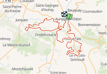
Randonnée V.T.T. de 43 km à découvrir à Normandie, Calvados, Les Monts d'Aunay. Cette randonnée est proposée par tracegps.
Description
Parcours des 48km. La plus belle rando (avec le raid de pont d'Ouilly) que j'ai faite!!! Alliant technique et ludique; belles montées , superbes descentes, singles en veux tu en voila!!! A faire au moins une fois dans sa vie de vttiste.
Localisation
Pays :
France
Région :
Normandie
Département/Province :
Calvados
Commune :
Les Monts d'Aunay
Localité :
Aunay-sur-Odon
Départ:(Dec)
Départ:(UTM)
672680 ; 5431601 (30U) N.
Commentaires
Randonnées à proximité
![Randonnée V.T.T. Les Monts d'Aunay - Boucle d'Aunay via Hamars - Photo](https://media.geolcdn.com/t/375/260/ext.jpg?maxdim=2&url=https%3A%2F%2Fservices.sitytrail.com%2FGeolivesWS%2FDownloadMedia.ashx%3FTrailID%3D191363%26Media%3D14929_6.jpg)
![V.T.T. V.T.T.](https://static1.geolcdn.com/sitytour/trail-icons/202.png)
Boucle d'Aunay via Hamars
V.T.T.
Difficile
Les Monts d'Aunay,
Normandie,
Calvados,
France
![](/images/other/stat-length.png)
26 km | 33 km-effort
2h 0min
![](https://static1.geolcdn.com/siteimages/upload/files/16400158638029165_repeat_loop_refresh_sync_direction_icon.png)
Oui
![Randonnée Marche Les Monts d'Aunay - mt pincon trois monts - Photo](https://media.geolcdn.com/t/375/260/ext.jpg?maxdim=2&url=https%3A%2F%2Fservices.sitytrail.com%2FGeolivesWS%2FDownloadMedia.ashx%3FTrailID%3D178205%26Media%3Da6031ba0-7d82-4930-b9fa-f8f1b7324668.JPG)
![Marche Marche](https://static1.geolcdn.com/sitytour/trail-icons/101.png)
mt pincon trois monts
Marche
Difficile
Les Monts d'Aunay,
Normandie,
Calvados,
France
![](/images/other/stat-length.png)
29 km | 36 km-effort
6h 0min
![](https://static1.geolcdn.com/siteimages/upload/files/16400158638029165_repeat_loop_refresh_sync_direction_icon.png)
Non
![Randonnée V.T.T. Les Monts d'Aunay - L'Arbre de la Liberté - Chartres - Photo](https://media.geolcdn.com/t/375/260/ext.jpg?maxdim=2&url=https%3A%2F%2Fservices.sitytrail.com%2FGeolivesWS%2FDownloadMedia.ashx%3FTrailID%3D172787%26Media%3D14216_5.jpg)
![V.T.T. V.T.T.](https://static1.geolcdn.com/sitytour/trail-icons/202.png)
L'Arbre de la Liberté - Chartres
V.T.T.
Moyen
Les Monts d'Aunay,
Normandie,
Calvados,
France
![](/images/other/stat-length.png)
2756 km | 3635 km-effort
3h 19min
![](https://static1.geolcdn.com/siteimages/upload/files/16400158638029165_repeat_loop_refresh_sync_direction_icon.png)
Non
![Randonnée V.T.T. Les Monts d'Aunay - NormVass 2/6 7juin2022 - Photo](https://media.geolcdn.com/t/375/260/d0bc5af3-e059-40cb-bedf-b1f6bca4eeba.jpg&format=jpg&maxdim=2)
![V.T.T. V.T.T.](https://static1.geolcdn.com/sitytour/trail-icons/202.png)
NormVass 2/6 7juin2022
V.T.T.
Très difficile
Les Monts d'Aunay,
Normandie,
Calvados,
France
![](/images/other/stat-length.png)
47 km | 59 km-effort
8h 36min
![](https://static1.geolcdn.com/siteimages/upload/files/16400158638029165_repeat_loop_refresh_sync_direction_icon.png)
Non
![Randonnée A pied Les Monts d'Aunay - Sous les monts d'Aunay - Photo](https://media.geolcdn.com/t/375/260/b08a1bcf-1ecf-49f8-87f9-ebee83161d95.jpeg&format=jpg&maxdim=2)
![A pied A pied](https://static1.geolcdn.com/sitytour/trail-icons/100.png)
Sous les monts d'Aunay
A pied
Facile
Les Monts d'Aunay,
Normandie,
Calvados,
France
![](/images/other/stat-length.png)
8 km | 9,4 km-effort
2h 7min
![](https://static1.geolcdn.com/siteimages/upload/files/16400158638029165_repeat_loop_refresh_sync_direction_icon.png)
Oui
![Randonnée A pied Malherbe-sur-Ajon - La Vallée de l'Ajon - Photo](https://media.geolcdn.com/t/375/260/526b3219-597e-49aa-b241-0b2c006314c6.jpeg&format=jpg&maxdim=2)
![A pied A pied](https://static1.geolcdn.com/sitytour/trail-icons/100.png)
La Vallée de l'Ajon
A pied
Facile
Malherbe-sur-Ajon,
Normandie,
Calvados,
France
![](/images/other/stat-length.png)
14,4 km | 17,3 km-effort
3h 55min
![](https://static1.geolcdn.com/siteimages/upload/files/16400158638029165_repeat_loop_refresh_sync_direction_icon.png)
Oui
![Randonnée Marche Les Monts d'Aunay - ROUCAMPS 2 - Photo](https://media.geolcdn.com/t/375/260/ext.jpg?maxdim=2&url=https%3A%2F%2Fstatic1.geolcdn.com%2Fsiteimages%2Fupload%2Ffiles%2F1553511878bg_sport_marche.png)
![Marche Marche](https://static1.geolcdn.com/sitytour/trail-icons/101.png)
ROUCAMPS 2
Marche
Difficile
Les Monts d'Aunay,
Normandie,
Calvados,
France
![](/images/other/stat-length.png)
8,7 km | 11,2 km-effort
2h 52min
![](https://static1.geolcdn.com/siteimages/upload/files/16400158638029165_repeat_loop_refresh_sync_direction_icon.png)
Oui
![Randonnée A pied Le Mesnil-au-Grain - Petit Tour à Bauquay - Photo](https://media.geolcdn.com/t/375/260/ext.jpg?maxdim=2&url=https%3A%2F%2Fstatic1.geolcdn.com%2Fsiteimages%2Fupload%2Ffiles%2F1545311037marcheuse_200dpi.jpg)
![A pied A pied](https://static1.geolcdn.com/sitytour/trail-icons/100.png)
Petit Tour à Bauquay
A pied
Facile
Le Mesnil-au-Grain,
Normandie,
Calvados,
France
![](/images/other/stat-length.png)
4,3 km | 5,3 km-effort
1h 11min
![](https://static1.geolcdn.com/siteimages/upload/files/16400158638029165_repeat_loop_refresh_sync_direction_icon.png)
Oui
![Randonnée A pied Malherbe-sur-Ajon - Circuit de l'Orgueil - Photo](https://media.geolcdn.com/t/375/260/ext.jpg?maxdim=2&url=https%3A%2F%2Fstatic1.geolcdn.com%2Fsiteimages%2Fupload%2Ffiles%2F1545311037marcheuse_200dpi.jpg)
![A pied A pied](https://static1.geolcdn.com/sitytour/trail-icons/100.png)
Circuit de l'Orgueil
A pied
Facile
Malherbe-sur-Ajon,
Normandie,
Calvados,
France
![](/images/other/stat-length.png)
5,6 km | 6,6 km-effort
1h 30min
![](https://static1.geolcdn.com/siteimages/upload/files/16400158638029165_repeat_loop_refresh_sync_direction_icon.png)
Oui